
ચિત્ર:Adams bridge map.png
Adams_bridge_map.png (૫૧૯ × ૨૩૯ પીક્સલ, ફાઇલનું કદ: ૨૫ KB, MIME પ્રકાર: image/png)
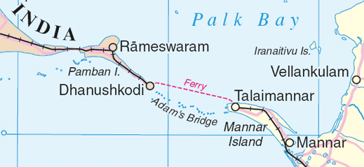
Map of en:Adam's Bridge, India/Sri Lanka
Extracted from www.un.org/Depts/Cartographic/map/profile/srilanka.pdf
| This image is a map derived from a United Nations map.
Unless stated otherwise, UN maps are to be considered in the public domain. This applies worldwide. UN maps are, in principle, open source material and you can use them in your work or for making your own map. UN requests however that you delete the UN name, logo and reference number upon any modification to the map. Content of your map will be your responsibility. You can state in your publication, if you wish, something like: based on UN map … (map name, map number, revision number and date). See: Geospatial Information Section. And: Geospatial, location data for a better world. |
 |
ફાઇલનો ઇતિહાસ
તારીખ/સમય ઉપર ક્લિક કરવાથી તે સમયે ફાઇલ કેવી હતી તે જોવા મળશે.
| તારીખ/સમય | લઘુચિત્ર | પરિમાણો | સભ્ય | ટિપ્પણી | |
|---|---|---|---|---|---|
| વર્તમાન | ૦૭:૨૫, ૪ ઓગસ્ટ ૨૦૦૬ | | ૫૧૯ × ૨૩૯ (૨૫ KB) | Gugganij | Map of Adam's Bridge, India/Sri Lanka Extracted from http://www.un.org/Depts/Cartographic/map/profile/srilanka.pdf {{UN map}} |
ફાઇલનો વપરાશ
આ ફાઇલ માં નીચેનું પાનું વપરાયેલું છે:
ફાઇલનો વ્યાપક ઉપયોગ
નીચેની બીજી વિકિઓ આ ફાઈલ વાપરે છે:
- ar.wikipedia.org પર વપરાશ
- az.wikipedia.org પર વપરાશ
- ba.wikipedia.org પર વપરાશ
- be.wikipedia.org પર વપરાશ
- bn.wikipedia.org પર વપરાશ
- cs.wikipedia.org પર વપરાશ
- de.wikipedia.org પર વપરાશ
- el.wikipedia.org પર વપરાશ
- en.wikipedia.org પર વપરાશ
- eo.wikipedia.org પર વપરાશ
- es.wikipedia.org પર વપરાશ
- et.wikipedia.org પર વપરાશ
- fi.wikipedia.org પર વપરાશ
- fr.wikipedia.org પર વપરાશ
- fy.wikipedia.org પર વપરાશ
- gl.wikipedia.org પર વપરાશ
- he.wikipedia.org પર વપરાશ
- hu.wikipedia.org પર વપરાશ
- id.wikipedia.org પર વપરાશ
- it.wikipedia.org પર વપરાશ
- ja.wikipedia.org પર વપરાશ
- kn.wikipedia.org પર વપરાશ
- ko.wikipedia.org પર વપરાશ
- la.wikipedia.org પર વપરાશ
- lt.wikipedia.org પર વપરાશ
- mai.wikipedia.org પર વપરાશ
- mk.wikipedia.org પર વપરાશ
- ml.wikipedia.org પર વપરાશ
- new.wikipedia.org પર વપરાશ
- nl.wikipedia.org પર વપરાશ
આ ફાઇલના વધુ વૈશ્વિક વપરાશ જુઓ.