
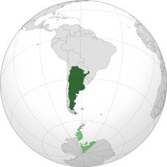
ચિત્ર:Argentina orthographic.svg

Size of this PNG preview of this SVG file: ૫૫૦ × ૫૫૦ પિક્સેલ. અન્ય આવર્તનો: ૨૪૦ × ૨૪૦ પિક્સેલ | ૪૮૦ × ૪૮૦ પિક્સેલ | ૭૬૮ × ૭૬૮ પિક્સેલ | ૧,૦૨૪ × ૧,૦૨૪ પિક્સેલ | ૨,૦૪૮ × ૨,૦૪૮ પિક્સેલ.
મૂળભુત ફાઇલ (SVG ફાઇલ, માત્ર ૫૫૦ × ૫૫૦ પીક્સલ, ફાઇલનું કદ: ૬૯૧ KB)
સારાંશ:
| વર્ણન |
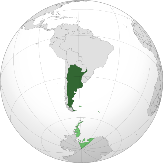
English: Orthographic map of Argentina centered on Buenos Aires
Official territory.
Claimed territories. Español: Mapa ortográfico de la Argentina centrado en Buenos Aires
Territorio oficial.
Territorios en disputa. |
| તારીખ | |
| સ્રોત | પોતાની રચના with Natural Earth Data |
| લેખક | Addicted04 |
| SVG genesis |
El único territorio que reclama son las malvinas, son los puntos verdes chiquitos, la antártida o el triangulo de abajo es argentino.
.svg)
.svg)
.svg)
.svg)
.svg)
.svg)
.svg)
.svg)
.svg)
.svg)
.svg)
.svg)
.svg)
.svg)
.svg)
.svg)
.svg)
.svg)
.svg)
.svg)
.svg)
.svg)
.svg)
.svg)
.svg)
.svg)
.svg)
.svg)
.svg)
.svg)
.svg)
.svg)
.svg)
.svg)
.svg)
.svg)
.svg)
.svg)
.svg)
.svg)
.svg)
.svg)
.svg)
.svg)
.svg)
.svg)
.svg)
.svg)
.svg)
.svg)
.svg)
.svg)
.svg)
.svg)
.svg)
.svg)
.svg)
.svg)
.svg)
.svg)
.svg)
.svg)
.svg)
.svg)
.svg)
.svg)
.svg)
.svg)
.svg)
.svg)
.svg)
.svg)
.svg)
.svg)

.svg)

.svg)

.svg)
.svg)
.svg)
.svg)
.svg)
.svg)
.svg)


.svg)
.svg)
.svg)
.svg)
.svg)
.svg)
.svg)

.svg)
.svg)
.svg)
.svg)
.svg)
.svg)
.svg)
.svg)
.svg)

.svg)
.svg)
.svg)
.svg)
.svg)
.svg)
.svg)
_without_national_boundaries.svg)
.svg)
.svg)
.svg)
.svg)
.svg)
.svg)

.svg)
.svg)
.png)
.svg)
.svg)
.svg)
.svg)

.svg)
.svg)
.svg)
.svg)
.svg)
.svg)
.svg)
.svg)
.svg)
.svg)
.svg)

.svg)
.svg)
.svg)
.svg)
.svg)
.svg)
.svg)
.svg)
.svg)

.svg)
.svg)

.svg)
.svg)
.svg)
.svg)
.svg)
.svg)
.svg)
.svg)
.svg)
.svg)
.svg)
.svg)
.svg)
.svg)
.svg)
.svg)
.svg)
.svg)
.svg)
.svg)
.svg)
.svg)
.svg)
.svg)
.svg)
.svg)
.svg)
_-_Crimea_disputed.svg)
.svg)
.svg)
.svg)
.svg)
.svg)
.svg)
.svg)
.svg)
.svg)
.svg)
.svg)
_political.svg)
.svg)
.svg)
.svg)
.svg)
_-_Crimea_disputed_-_no_borders.svg)
.svg)
.svg)
.svg)
.svg)
.svg)
.svg)
.svg)
.svg)
.svg)
.svg)
.svg)

.svg)
.svg)
.svg)

.png)
.svg)
.svg)
.svg)
.svg)
.svg)
.svg)
.svg)
.svg)
.svg)
.svg)
.svg)
.svg)
.svg)
.svg)
.svg)
.svg)
.svg)
.svg)
.svg)
.svg)
.svg)
.svg)
.svg)
.svg)
.svg)
.svg)
.svg)
.svg)
.svg)
.svg)
.svg)
.svg)
.svg)
.svg)
.png)
.svg)
.svg)
.svg)
_(orthographic_projection).png)
| Orthographic projections maps created by Ssolbergj |
|---|
| Orthographic projections maps created by Ssolbergj: |
.svg)
.svg)
પરવાના
હું, આ કાર્યનો પ્રકાશનાધિકાર ધારક, તેને નીચેના પરવાના હેઠળ અહીં પ્રકાશીત કરૂં છું:
આ ફાઈલ વપરાશની પરવાનગી :Creative Commons Attribution 3.0 Unported license.
- તમે મુક્ત છો:
- વહેંચવા – નકલ કરવા, વિતરણ કરવા અને રચનાઓ મોકલવા
- રીમિક્સ કરવા કે મઠારવા – રચના અપનાવવા
- નીચેની શરત હેઠળ:
- આરોપણ – તમારે આ રચનાનો ઉપયોગ કરવા માટે લેખક કે પ્રકાશન અધિકાર ધારકની યોગ્ય માહિતી, પરવાનગી (લાયસન્સ)ની કડી અને તેમાં ફેરફાર કર્યો હોય તો તેનો ઉલ્લેખ કરવો જ પડશે. તમે આ સત્તા અનુસાર જ આ રચનાનો પ્રયોગ થવો જોઈએ, પણ તેઓ તમને અથવા તમારા ઉપયોગ સાથે સંમત થાય છે તે રીતે નહીં.
ફાઇલનો ઇતિહાસ
તારીખ/સમય ઉપર ક્લિક કરવાથી તે સમયે ફાઇલ કેવી હતી તે જોવા મળશે.
| તારીખ/સમય | લઘુચિત્ર | પરિમાણો | સભ્ય | ટિપ્પણી | |
|---|---|---|---|---|---|
| વર્તમાન | ૨૨:૧૮, ૧૮ જુલાઇ ૨૦૧૩ | | ૫૫૦ × ૫૫૦ (૬૯૧ KB) | Montgomery | Reverted to version as of 22:50, 22 October 2011; COM:GL/M standars |
| ૨૧:૩૮, ૧૮ જુલાઇ ૨૦૧૩ |  | ૫૫૦ × ૫૫૦ (૬૯૭ KB) | Cesardavidd | Reverted to version as of 20:32, 22 June 2011 | |
| ૦૪:૨૦, ૨૩ ઓક્ટોબર ૨૦૧૧ |  | ૫૫૦ × ૫૫૦ (૬૯૧ KB) | Addicted04 | claimed color | |
| ૦૪:૦૯, ૨૩ ઓક્ટોબર ૨૦૧૧ |  | ૫૫૦ × ૫૫૦ (૬૯૦ KB) | Addicted04 | claimed color | |
| ૦૨:૦૨, ૨૩ જૂન ૨૦૧૧ |  | ૫૫૦ × ૫૫૦ (૬૯૭ KB) | Addicted04 | latitude line | |
| ૦૨:૩૮, ૨૨ જૂન ૨૦૧૧ |  | ૫૫૦ × ૫૫૦ (૬૯૨ KB) | Addicted04 |
ફાઇલનો વપરાશ
આ ફાઇલ માં નીચેનું પાનું વપરાયેલું છે:
ફાઇલનો વ્યાપક ઉપયોગ
નીચેની બીજી વિકિઓ આ ફાઈલ વાપરે છે:
- an.wikipedia.org પર વપરાશ
- ar.wikipedia.org પર વપરાશ
- as.wikipedia.org પર વપરાશ
- av.wikipedia.org પર વપરાશ
- awa.wikipedia.org પર વપરાશ
- ay.wikipedia.org પર વપરાશ
- azb.wikipedia.org પર વપરાશ
- bh.wikipedia.org પર વપરાશ
- bm.wikipedia.org પર વપરાશ
- bn.wikipedia.org પર વપરાશ
- bo.wikipedia.org પર વપરાશ
- bpy.wikipedia.org પર વપરાશ
- br.wikipedia.org પર વપરાશ
- bxr.wikipedia.org પર વપરાશ
- ca.wikipedia.org પર વપરાશ
- cbk-zam.wikipedia.org પર વપરાશ
- cdo.wikipedia.org પર વપરાશ
- ceb.wikipedia.org પર વપરાશ
- chr.wikipedia.org પર વપરાશ
- ch.wikipedia.org પર વપરાશ
- co.wikipedia.org પર વપરાશ
- crh.wikipedia.org પર વપરાશ
- cv.wikipedia.org પર વપરાશ
- de.wiktionary.org પર વપરાશ
- dsb.wikipedia.org પર વપરાશ
- dty.wikipedia.org પર વપરાશ
- ee.wikipedia.org પર વપરાશ
- en.wikipedia.org પર વપરાશ
- es.wikipedia.org પર વપરાશ
- Categoría:Provincia de Buenos Aires
- Categoría:Provincia de Catamarca
- Categoría:Provincia de Chaco
- Categoría:Provincia de Córdoba (Argentina)
- Categoría:Provincia de Corrientes
- Categoría:Provincia de Entre Ríos
- Categoría:Provincia de Formosa
- Categoría:Provincia de Jujuy
- Categoría:Provincia de La Pampa
- Categoría:Provincia de La Rioja (Argentina)
- Categoría:Provincia de Mendoza
- Categoría:Provincia de Río Negro
- Categoría:Provincia de Salta
આ ફાઇલના વધુ વૈશ્વિક વપરાશ જુઓ.