
ચિત્ર:China India eastern border 88.jpg

આ પૂર્વાવલોકનનું કદ: ૪૮૩ × ૬૦૦ પિક્સેલ. અન્ય આવર્તનો: ૧૯૩ × ૨૪૦ પિક્સેલ | ૩૮૭ × ૪૮૦ પિક્સેલ | ૧,૦૧૯ × ૧,૨૬૫ પિક્સેલ.
મૂળભુત ફાઇલ (૧,૦૧૯ × ૧,૨૬૫ પીક્સલ, ફાઇલનું કદ: ૨૯૭ KB, MIME પ્રકાર: image/jpeg)
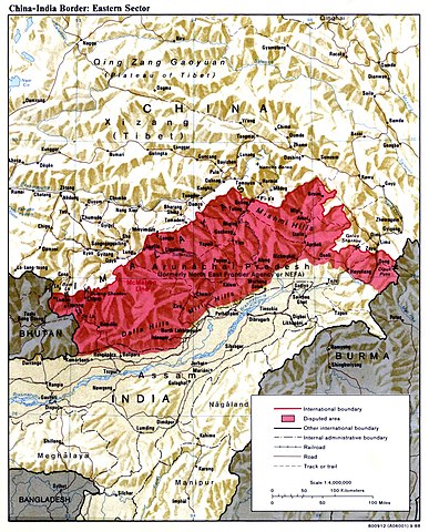
| વર્ણન | China India eastern border depicting disputed areas in this sector including NEFA. | |||
| તારીખ | ||||
| સ્રોત | http://www.lib.utexas.edu/maps/middle_east_and_asia/china_india_e_border_88.jpg | |||
| લેખક | Central Intelligence Agency | |||
| પરવાનગી (આ ફાઈલનો ફરી ઉપયોગ) |
|
|||
| અન્ય આવૃત્તિઓ |
 |

| Annotations | This image is annotated: View the annotations at Commons |
ફાઇલનો ઇતિહાસ
તારીખ/સમય ઉપર ક્લિક કરવાથી તે સમયે ફાઇલ કેવી હતી તે જોવા મળશે.
| તારીખ/સમય | લઘુચિત્ર | પરિમાણો | સભ્ય | ટિપ્પણી | |
|---|---|---|---|---|---|
| વર્તમાન | ૧૦:૨૯, ૨ એપ્રિલ ૨૦૦૭ | | ૧,૦૧૯ × ૧,૨૬૫ (૨૯૭ KB) | Yuje | China India eastern border depicting disputed areas in this sector including NEFA. Taken from [http://www.lib.utexas.edu/maps/middle_east_and_asia/china_indiae_border_88.jpg] |
ફાઇલનો વપરાશ
આ ફાઇલ માં નીચેનું પાનું વપરાયેલું છે:
ફાઇલનો વ્યાપક ઉપયોગ
નીચેની બીજી વિકિઓ આ ફાઈલ વાપરે છે:
- as.wikipedia.org પર વપરાશ
- bn.wikipedia.org પર વપરાશ
- cs.wikipedia.org પર વપરાશ
- de.wikipedia.org પર વપરાશ
- en.wikipedia.org પર વપરાશ
- es.wikipedia.org પર વપરાશ
- fa.wikipedia.org પર વપરાશ
- fr.wikipedia.org પર વપરાશ
- he.wikipedia.org પર વપરાશ
- hi.wikipedia.org પર વપરાશ
- hr.wikipedia.org પર વપરાશ
- hu.wikipedia.org પર વપરાશ
- id.wikipedia.org પર વપરાશ
- it.wikipedia.org પર વપરાશ
- ja.wikipedia.org પર વપરાશ
- kn.wikipedia.org પર વપરાશ
- ko.wikipedia.org પર વપરાશ
- ky.wikipedia.org પર વપરાશ
- lt.wikipedia.org પર વપરાશ
- ms.wikipedia.org પર વપરાશ
- ne.wikipedia.org પર વપરાશ
- nl.wikipedia.org પર વપરાશ
- pa.wikipedia.org પર વપરાશ
- pl.wikipedia.org પર વપરાશ
- pnb.wikipedia.org પર વપરાશ
- pt.wikipedia.org પર વપરાશ
આ ફાઇલના વધુ વૈશ્વિક વપરાશ જુઓ.