
ચિત્ર:Dadra and Nagar Haveli in India.png
Dadra_and_Nagar_Haveli_in_India.png (૩૫૦ × ૪૨૫ પીક્સલ, ફાઇલનું કદ: ૮૧ KB, MIME પ્રકાર: image/png)
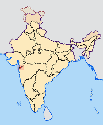
Dadra and Nagar Haveli is an Indian Union Territory
--- Map made by me, Nichalp
--- Note: The Indian state of w:Jammu and Kashmir is claimed by w:India, w:Pakistan and the w:People's Republic of China. This map depicts the boundaries of the state as it was in 1947. Areas administered by India is coloured as per the rest of the states, and the area administered by Pakistan and China are coloured in a neutral colour. See the map of Jammu and Kashmir.
The Indian state of w:Arunachal Pradesh is claimed by China as a part of w:South Tibet. The claimed region is depicted in a pale shade of pink. See the map of Arunachal Pradesh.
The Indian territorial waters extend to a distance of twelve nautical miles.

|
આ રચનાની નકલ કરવા, વિતરણ અને સુધારો કરવા માટે GNU Free Documentation License, આવૃત્તિ 1.2 કે અન્ય આગળની આવૃત્તિ Free Software Foundation હેઠળ પરવાનગી છે; જેમાં કોઈ Invariant Sections, no Front-Cover Texts, and no Back-Cover Texts નથી. આ પરવાનાની પ્રત GNU Free Documentation License વિભાગમાં છે. |
| આ ફાઈલ વપરાશની પરવાનગી : Creative Commons Attribution-Share Alike 3.0 Unported license. | ||
| ||
| GFDL licensing update ના ભાગ રૂપે આ પરવાનાનો ટેગ ફાઈલ પર લગાડવામાં આવ્યો છે. |
ફાઇલનો ઇતિહાસ
તારીખ/સમય ઉપર ક્લિક કરવાથી તે સમયે ફાઇલ કેવી હતી તે જોવા મળશે.
| તારીખ/સમય | લઘુચિત્ર | પરિમાણો | સભ્ય | ટિપ્પણી | |
|---|---|---|---|---|---|
| વર્તમાન | ૧૩:૨૫, ૨૩ એપ્રિલ ૨૦૦૫ | | ૩૫૦ × ૪૨૫ (૮૧ KB) | Nichalp | NPOV map |
| ૨૩:૨૩, ૨૧ એપ્રિલ ૨૦૦૫ |  | ૬૫૦ × ૭૯૦ (૧૨૭ KB) | Nichalp | Dadra and Nagar Haveli is an Indian Union Territory --- Map made by me, ~~~ --- Note: The Indian state of w:Jammu and Kashmir is claimed by w:India, w:Pakistan and the w:People's Republic of China. This map depicts the boundaries of the |
ફાઇલનો વપરાશ
આ ફાઇલને કોઇ પાનાં વાપરતા નથી.
ફાઇલનો વ્યાપક ઉપયોગ
નીચેની બીજી વિકિઓ આ ફાઈલ વાપરે છે:
- bxr.wikipedia.org પર વપરાશ
- ka.wikipedia.org પર વપરાશ
- pam.wikipedia.org પર વપરાશ
- uk.wikipedia.org પર વપરાશ
- xmf.wikipedia.org પર વપરાશ
- zh-min-nan.wikipedia.org પર વપરાશ