
ચિત્ર:Ghana Regions map.png

આ પૂર્વાવલોકનનું કદ: ૪૦૧ × ૫૯૯ પિક્સેલ. અન્ય આવર્તનો: ૧૬૧ × ૨૪૦ પિક્સેલ | ૩૨૧ × ૪૮૦ પિક્સેલ | ૫૧૪ × ૭૬૮ પિક્સેલ | ૬૮૫ × ૧,૦૨૪ પિક્સેલ | ૧,૪૯૫ × ૨,૨૩૩ પિક્સેલ.
મૂળભુત ફાઇલ (૧,૪૯૫ × ૨,૨૩૩ પીક્સલ, ફાઇલનું કદ: ૧.૦૩ MB, MIME પ્રકાર: image/png)
સારાંશ:
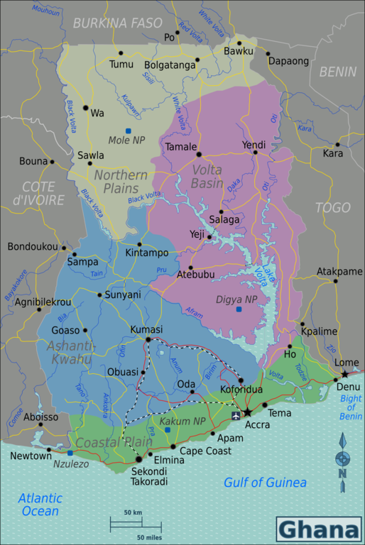
| વર્ણન | Map of Ghana for use on Wikivoyage, English version |
| તારીખ | |
| સ્રોત | પોતાની રચના based on Perry-Castañeda Library Map Collection Ghana Maps |
| લેખક | Burmesedays, minor amendments by Joelf |
| અન્ય આવૃત્તિઓ |
.png)
.png)
પરવાના
આ ફાઈલ વપરાશની પરવાનગી : Creative Commons Attribution-Share Alike 3.0 Unported license.
- તમે મુક્ત છો:
- વહેંચવા – નકલ કરવા, વિતરણ કરવા અને રચનાઓ મોકલવા
- રીમિક્સ કરવા કે મઠારવા – રચના અપનાવવા
- નીચેની શરત હેઠળ:
- આરોપણ – તમારે આ રચનાનો ઉપયોગ કરવા માટે લેખક કે પ્રકાશન અધિકાર ધારકની યોગ્ય માહિતી, પરવાનગી (લાયસન્સ)ની કડી અને તેમાં ફેરફાર કર્યો હોય તો તેનો ઉલ્લેખ કરવો જ પડશે. તમે આ સત્તા અનુસાર જ આ રચનાનો પ્રયોગ થવો જોઈએ, પણ તેઓ તમને અથવા તમારા ઉપયોગ સાથે સંમત થાય છે તે રીતે નહીં.
- શેર- અલાઈક (બિન ભેદભાવ વહેંચણી) – તમે જો આ રચનાને બદલશો, તેમાં ફેરફાર કરશો અથવા તેના પર આધારિત કોઇ કાર્ય બનાવશો તો તમારે પરિણામી કાર્યને તે જ અથવા અનુરૂપ પરવાનગી હેઠળ જ પ્રકાશિત કરવું પડશે.
અસલ - મૂળ અપલોડનો લોગ
| This file was imported from Wikivoyage WTS. |
The original description page was here. All following user names refer to wts.wikivoyage-old.
- 2010-02-02 09:09 (WT-shared) Burmesedays[dead link] 1500×2241 (1063131 bytes) {{Imagecredit|credit=[[user:burmesedays]], [http://www.lib.utexas.edu/maps/Ghana.html Perry-Castañeda Library Map Collection Ghana Maps]|ca (Import from wikitravel.org/shared)
- 2010-04-25 08:44 (WT-shared) Burmesedays[dead link] 1500×2241 (1085999 bytes) (Import from wikitravel.org/shared)
- 2012-03-05 00:52 (WT-shared) Joelf[dead link] 1495×2233 (1082693 bytes) Fixed minor misspellings (Import from wikitravel.org/shared)
ફાઇલનો ઇતિહાસ
તારીખ/સમય ઉપર ક્લિક કરવાથી તે સમયે ફાઇલ કેવી હતી તે જોવા મળશે.
| તારીખ/સમય | લઘુચિત્ર | પરિમાણો | સભ્ય | ટિપ્પણી | |
|---|---|---|---|---|---|
| વર્તમાન | ૨૧:૦૨, ૨૩ નવેમ્બર ૨૦૧૨ | | ૧,૪૯૫ × ૨,૨૩૩ (૧.૦૩ MB) | OgreBot | (BOT): Reverting to most recent version before archival |
| ૨૧:૦૨, ૨૩ નવેમ્બર ૨૦૧૨ |  | ૧,૫૦૦ × ૨,૨૪૧ (૧.૦૪ MB) | OgreBot | (BOT): Uploading old version of file from wts.wikivoyage-old; originally uploaded on 2010-04-25 08:44:25 by (WT-shared) Burmesedays | |
| ૨૧:૦૨, ૨૩ નવેમ્બર ૨૦૧૨ |  | ૧,૫૦૦ × ૨,૨૪૧ (૧.૦૧ MB) | OgreBot | (BOT): Uploading old version of file from wts.wikivoyage-old; originally uploaded on 2010-02-02 09:09:17 by (WT-shared) Burmesedays | |
| ૦૫:૨૦, ૧૮ નવેમ્બર ૨૦૧૨ |  | ૧,૪૯૫ × ૨,૨૩૩ (૧.૦૩ MB) | MGA73bot2 | {{BotMoveToCommons|wts.oldwikivoyage|year={{subst:CURRENTYEAR}}|month={{subst:CURRENTMONTHNAME}}|day={{subst:CURRENTDAY}}}} == {{int:filedesc}} == {{Information |description=Map of Ghana. Map of Ghana, Ghana * Map of: Ghana¤ |date=February 2nd 2010 |s... |
ફાઇલનો વપરાશ
આ ફાઇલ માં નીચેનું પાનું વપરાયેલું છે:
ફાઇલનો વ્યાપક ઉપયોગ
નીચેની બીજી વિકિઓ આ ફાઈલ વાપરે છે:
- bn.wikipedia.org પર વપરાશ
- de.wikivoyage.org પર વપરાશ
- en.wikipedia.org પર વપરાશ
- en.wikivoyage.org પર વપરાશ
- es.wikipedia.org પર વપરાશ
- fa.wikipedia.org પર વપરાશ
- gpe.wikipedia.org પર વપરાશ
- he.wikivoyage.org પર વપરાશ
- incubator.wikimedia.org પર વપરાશ
- it.wikivoyage.org પર વપરાશ
- ja.wikivoyage.org પર વપરાશ
- ku.wikipedia.org પર વપરાશ
- si.wikipedia.org પર વપરાશ
- uk.wikivoyage.org પર વપરાશ
- vi.wikivoyage.org પર વપરાશ
- zh.wikivoyage.org પર વપરાશ