
ચિત્ર:Greater london outline map bw.png
આથી વધુ ઘનત્વ ઉપલબ્ધ નથી.
Greater_london_outline_map_bw.png (૬૦૦ × ૫૦૦ પીક્સલ, ફાઇલનું કદ: ૧૯૯ KB, MIME પ્રકાર: image/png)

|
File:Greater London UK location map 2.svg is a vector version of this file. It should be used in place of this PNG file when not inferior.
File:Greater london outline map bw.png → File:Greater London UK location map 2.svg
For more information, see Help:SVG. |
 |
સારાંશ:
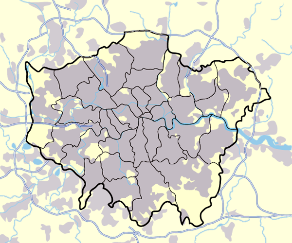
Image:Greater_london_outline_map.png showing built up areas in grey, motorways in blue, water-bodies in light-blue and London borough and county boundaries in black.
Based on a map originally by User:ChrisO.
Revised to correct motorways. DavidCane 19:42, 31 March 2007 (UTC)
પરવાના

|
આ રચનાની નકલ કરવા, વિતરણ અને સુધારો કરવા માટે GNU Free Documentation License, આવૃત્તિ 1.2 કે અન્ય આગળની આવૃત્તિ Free Software Foundation હેઠળ પરવાનગી છે; જેમાં કોઈ Invariant Sections, no Front-Cover Texts, and no Back-Cover Texts નથી. આ પરવાનાની પ્રત GNU Free Documentation License વિભાગમાં છે. |
| આ ફાઈલ વપરાશની પરવાનગી : Creative Commons Attribution-Share Alike 3.0 Unported license. | ||
| ||
| GFDL licensing update ના ભાગ રૂપે આ પરવાનાનો ટેગ ફાઈલ પર લગાડવામાં આવ્યો છે. |
| Annotations | This image is annotated: View the annotations at Commons |
ફાઇલનો ઇતિહાસ
તારીખ/સમય ઉપર ક્લિક કરવાથી તે સમયે ફાઇલ કેવી હતી તે જોવા મળશે.
| તારીખ/સમય | લઘુચિત્ર | પરિમાણો | સભ્ય | ટિપ્પણી | |
|---|---|---|---|---|---|
| વર્તમાન | ૨૨:૪૩, ૧૧ માર્ચ ૨૦૦૮ | | ૬૦૦ × ૫૦૦ (૧૯૯ KB) | Jza84 | slight alteration making the boundaries clearer between Newham and Barking and Dagenham - Ealing and Hounslow - and City of London and the City of Westminster |
| ૦૧:૧૦, ૧ એપ્રિલ ૨૦૦૭ |  | ૬૦૦ × ૫૦૦ (૨૧૭ KB) | DavidCane | ||
| ૨૦:૦૩, ૧૯ માર્ચ ૨૦૦૭ |  | ૬૦૦ × ૫૦૦ (૫૧૨ KB) | Jza84 | minor colour correction | |
| ૨૦:૦૦, ૧૯ માર્ચ ૨૦૦૭ |  | ૬૦૦ × ૫૦૦ (૫૧૨ KB) | Jza84 | yellowed white backdrop and altered blue of water bodies inline with UK mapping | |
| ૧૬:૪૬, ૧૫ માર્ચ ૨૦૦૭ |  | ૬૦૦ × ૫૦૦ (૫૫૨ KB) | Jza84 | Corrected some issues with Motorways and borough boundaries. | |
| ૦૦:૫૨, ૨૬ ફેબ્રુઆરી ૨૦૦૭ |  | ૬૦૦ × ૫૦૦ (૪૭૬ KB) | Jza84 | Map of Greater London and area. Self made and released to public domain. | |
| ૨૩:૩૯, ૧૮ નવેમ્બર ૨૦૦૬ |  | ૬૦૦ × ૫૦૦ (૨૧ KB) | Dtcdthingy~commonswiki | Image:Greater_london_outline_map.png with toned down colour scheme. Originally by User:ChrisO. |
ફાઇલનો વપરાશ
આ ફાઇલ માં નીચેનું પાનું વપરાયેલું છે:
ફાઇલનો વ્યાપક ઉપયોગ
નીચેની બીજી વિકિઓ આ ફાઈલ વાપરે છે:
- ast.wikipedia.org પર વપરાશ
- be.wikipedia.org પર વપરાશ
- bg.wikipedia.org પર વપરાશ
- ca.wikipedia.org પર વપરાશ
- da.wikipedia.org પર વપરાશ
- EFL League Championship
- Brugerdiskussion:Lindberg
- Westminster
- Charing Cross
- Skabelon:Kortpositioner Greater London
- Seven Sisters
- Tottenham
- Premier League
- Chelsea (London)
- Premier League 2013-14
- Premier League 2014-15
- Premier League 2015-16
- Attentatet i Finsbury Park 2017
- Premier League 2016-17
- The Football League 1927-28
- The Football League 1928-29
- The Football League 1929-30
- The Football League 1930-31
- The Football League 1931-32
- The Football League 1932-33
- de.wikipedia.org પર વપરાશ
- en.wikipedia.org પર વપરાશ
- en.wikinews.org પર વપરાશ
- eo.wikipedia.org પર વપરાશ
- es.wikipedia.org પર વપરાશ
- eu.wikipedia.org પર વપરાશ
- fa.wikipedia.org પર વપરાશ
- fr.wikipedia.org પર વપરાશ
- hy.wikipedia.org પર વપરાશ
આ ફાઇલના વધુ વૈશ્વિક વપરાશ જુઓ.