
ચિત્ર:Iowa overview.jpg

આ પૂર્વાવલોકનનું કદ: ૮૦૦ × ૫૪૦ પિક્સેલ. અન્ય આવર્તનો: ૩૨૦ × ૨૧૬ પિક્સેલ | ૬૪૦ × ૪૩૨ પિક્સેલ | ૧,૦૨૪ × ૬૯૧ પિક્સેલ | ૧,૨૮૦ × ૮૬૪ પિક્સેલ | ૨,૫૬૦ × ૧,૭૨૯ પિક્સેલ | ૩,૫૬૦ × ૨,૪૦૪ પિક્સેલ.
મૂળભુત ફાઇલ (૩,૫૬૦ × ૨,૪૦૪ પીક્સલ, ફાઇલનું કદ: ૧.૫૧ MB, MIME પ્રકાર: image/jpeg)

|
This locator map image could be re-created using vector graphics as an SVG file. This has several advantages; see Commons:Media for cleanup for more information. If an SVG form of this image is available, please upload it and afterwards replace this template with
{{vector version available|new image name}}.
It is recommended to name the SVG file “Iowa overview.svg”—then the template Vector version available (or Vva) does not need the new image name parameter. |


| વર્ણન |
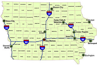
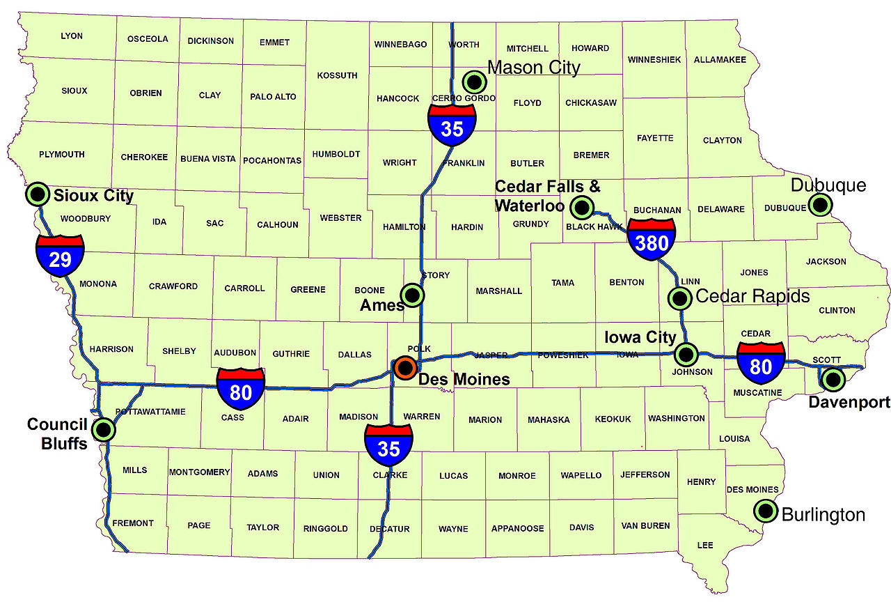
English: Iowa, showing counties, large cities, and main interstates. Made ArcMap, trimmed in Photoshop. |
| તારીખ | |
| સ્રોત | પોતાની રચના (Original text: I created this work entirely by myself.) |
| લેખક | Billwhittaker (talk) |
પરવાના
Billwhittaker at અંગ્રેજી વિકિપીડિયા, આ કાર્યનો પ્રકાશનાધિકાર ધારક, તેને નીચેના પરવાનાઓ હેઠળ અહીં પ્રકાશીત કરે છે:
આ ફાઈલ વપરાશની પરવાનગી : Creative Commons Attribution-Share Alike 3.0 Unported license.
આરોપણ: Billwhittaker at અંગ્રેજી વિકિપીડિયા
- તમે મુક્ત છો:
- વહેંચવા – નકલ કરવા, વિતરણ કરવા અને રચનાઓ મોકલવા
- રીમિક્સ કરવા કે મઠારવા – રચના અપનાવવા
- નીચેની શરત હેઠળ:
- આરોપણ – તમારે આ રચનાનો ઉપયોગ કરવા માટે લેખક કે પ્રકાશન અધિકાર ધારકની યોગ્ય માહિતી, પરવાનગી (લાયસન્સ)ની કડી અને તેમાં ફેરફાર કર્યો હોય તો તેનો ઉલ્લેખ કરવો જ પડશે. તમે આ સત્તા અનુસાર જ આ રચનાનો પ્રયોગ થવો જોઈએ, પણ તેઓ તમને અથવા તમારા ઉપયોગ સાથે સંમત થાય છે તે રીતે નહીં.
- શેર- અલાઈક (બિન ભેદભાવ વહેંચણી) – તમે જો આ રચનાને બદલશો, તેમાં ફેરફાર કરશો અથવા તેના પર આધારિત કોઇ કાર્ય બનાવશો તો તમારે પરિણામી કાર્યને તે જ અથવા અનુરૂપ પરવાનગી હેઠળ જ પ્રકાશિત કરવું પડશે.

|
આ રચનાની નકલ કરવા, વિતરણ અને સુધારો કરવા માટે GNU Free Documentation License, આવૃત્તિ 1.2 કે અન્ય આગળની આવૃત્તિ Free Software Foundation હેઠળ પરવાનગી છે; જેમાં કોઈ Invariant Sections, no Front-Cover Texts, and no Back-Cover Texts નથી. આ પરવાનાની પ્રત GNU Free Documentation License વિભાગમાં છે. |
તમે તમારી પસંદગીનો પરવાનો પસંદ કરી શકો છો.
અસલ - મૂળ અપલોડનો લોગ
Transferred from en.wikipedia to Commons by Sfan00_IMG using CommonsHelper.
The original description page was here. All following user names refer to en.wikipedia.
- 2008-12-29 13:59 Billwhittaker 3560×2404× (1580508 bytes) new and improved, with 20% more dubuque!
- 2008-09-04 14:41 Billwhittaker 3560×2404× (1569120 bytes) {{Information |Description= |Source=I created this work entirely by myself. |Date= |Author=~~~ |other_versions= }}
- 2008-09-04 14:39 Billwhittaker 3560×2404× (1569120 bytes) {{Information |Description= |Source=I created this work entirely by myself. |Date= |Author=~~~ |other_versions= }}
- 2008-09-02 16:11 Billwhittaker 3560×2404× (1522705 bytes) {{Information |Description=Iowa, showing counties, large cities, and main interstates. Made ArcMap, trimmed in Photoshop. |Source=I created this work entirely by myself. |Date=2008 |Author=~~~ |other_versions= }}
ફાઇલનો ઇતિહાસ
તારીખ/સમય ઉપર ક્લિક કરવાથી તે સમયે ફાઇલ કેવી હતી તે જોવા મળશે.
| તારીખ/સમય | લઘુચિત્ર | પરિમાણો | સભ્ય | ટિપ્પણી | |
|---|---|---|---|---|---|
| વર્તમાન | ૨૦:૦૭, ૧૪ એપ્રિલ ૨૦૦૯ | | ૩,૫૬૦ × ૨,૪૦૪ (૧.૫૧ MB) | File Upload Bot (Magnus Manske) | {{BotMoveToCommons|en.wikipedia|year={{subst:CURRENTYEAR}}|month={{subst:CURRENTMONTHNAME}}|day={{subst:CURRENTDAY}}}} {{Information |Description={{en|Iowa, showing counties, large cities, and main interstates. Made ArcMap, trimmed in Photoshop.<br/> == |
ફાઇલનો વપરાશ
આ ફાઇલ માં નીચેનું પાનું વપરાયેલું છે:
ફાઇલનો વ્યાપક ઉપયોગ
નીચેની બીજી વિકિઓ આ ફાઈલ વાપરે છે:
- en.wikipedia.org પર વપરાશ
- es.wikipedia.org પર વપરાશ
- ja.wikipedia.org પર વપરાશ
- kn.wikipedia.org પર વપરાશ
- zh.wikipedia.org પર વપરાશ