
ચિત્ર:Karnataka Ramanagara locator map.svg

Size of this PNG preview of this SVG file: ૪૨૩ × ૬૦૦ પિક્સેલ. અન્ય આવર્તનો: ૧૬૯ × ૨૪૦ પિક્સેલ | ૩૩૮ × ૪૮૦ પિક્સેલ | ૫૪૨ × ૭૬૮ પિક્સેલ | ૭૨૨ × ૧,૦૨૪ પિક્સેલ | ૧,૪૪૫ × ૨,૦૪૮ પિક્સેલ | ૮૯૮ × ૧,૨૭૩ પિક્સેલ.
મૂળભુત ફાઇલ (SVG ફાઇલ, માત્ર ૮૯૮ × ૧,૨૭૩ પીક્સલ, ફાઇલનું કદ: ૯૩૩ KB)
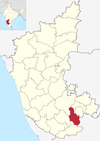
| વર્ણન | Location map of Ramanagara district in Karnataka. |
| તારીખ | (UTC) |
| સ્રોત | |
| લેખક |
|
| This is a retouched picture, which means that it has been digitally altered from its original version. Modifications: Highlighted Ramanagara district. The original can be viewed here: India Karnataka location map.svg:
|
આ ફાઈલ વપરાશની પરવાનગી : Creative Commons Attribution-Share Alike 3.0 Unported license.
- તમે મુક્ત છો:
- વહેંચવા – નકલ કરવા, વિતરણ કરવા અને રચનાઓ મોકલવા
- રીમિક્સ કરવા કે મઠારવા – રચના અપનાવવા
- નીચેની શરત હેઠળ:
- આરોપણ – તમારે આ રચનાનો ઉપયોગ કરવા માટે લેખક કે પ્રકાશન અધિકાર ધારકની યોગ્ય માહિતી, પરવાનગી (લાયસન્સ)ની કડી અને તેમાં ફેરફાર કર્યો હોય તો તેનો ઉલ્લેખ કરવો જ પડશે. તમે આ સત્તા અનુસાર જ આ રચનાનો પ્રયોગ થવો જોઈએ, પણ તેઓ તમને અથવા તમારા ઉપયોગ સાથે સંમત થાય છે તે રીતે નહીં.
- શેર- અલાઈક (બિન ભેદભાવ વહેંચણી) – તમે જો આ રચનાને બદલશો, તેમાં ફેરફાર કરશો અથવા તેના પર આધારિત કોઇ કાર્ય બનાવશો તો તમારે પરિણામી કાર્યને તે જ અથવા અનુરૂપ પરવાનગી હેઠળ જ પ્રકાશિત કરવું પડશે.
અસલ - મૂળ અપલોડનો લોગ
This image is a derivative work of the following images:
- File:India_Karnataka_location_map.svg licensed with Cc-by-sa-3.0
- 2010-11-15T15:50:48Z Nayvik 1630x2356 (211689 Bytes) Changed background color
- 2010-11-15T15:34:13Z Nayvik 1630x2356 (211293 Bytes) {{Information |Description=Location map of [[:en:Karnataka|Karnataka]] Geographic limits of the map: * 18.5°N * 11.0°N * 73.6°E * 78.7°E |Source=*[[:File:Karnataka_locator_map.svg|]], [http://www.censusindia.gov.in/2011-I
Uploaded with derivativeFX
ફાઇલનો ઇતિહાસ
તારીખ/સમય ઉપર ક્લિક કરવાથી તે સમયે ફાઇલ કેવી હતી તે જોવા મળશે.
| તારીખ/સમય | લઘુચિત્ર | પરિમાણો | સભ્ય | ટિપ્પણી | |
|---|---|---|---|---|---|
| વર્તમાન | ૦૯:૦૫, ૧૬ જૂન ૨૦૨૩ | | ૮૯૮ × ૧,૨૭૩ (૯૩૩ KB) | C1MM | updated bounds |
| ૦૯:૧૮, ૧૬ જુલાઇ ૨૦૨૧ |  | ૮૫૧ × ૧,૨૧૧ (૧.૦૫ MB) | C1MM | c bounds | |
| ૨૨:૫૪, ૨૦ નવેમ્બર ૨૦૧૦ |  | ૧,૬૩૦ × ૨,૩૫૬ (૨૦૭ KB) | Nayvik | {{Information |Description=Location map of Ramanagara district in Karnataka. |Source=*File:India_Karnataka_location_map.svg |Date=2010-11-20 17:23 (UTC) |Author=*File:India_Karnataka_location_map.svg: *[[:File:Karna |
ફાઇલનો વપરાશ
આ ફાઇલ માં નીચેનું પાનું વપરાયેલું છે:
ફાઇલનો વ્યાપક ઉપયોગ
નીચેની બીજી વિકિઓ આ ફાઈલ વાપરે છે:
- ar.wikipedia.org પર વપરાશ
- arz.wikipedia.org પર વપરાશ
- bn.wikipedia.org પર વપરાશ
- ca.wikipedia.org પર વપરાશ
- de.wikipedia.org પર વપરાશ
- en.wikipedia.org પર વપરાશ
- es.wikipedia.org પર વપરાશ
- eu.wikipedia.org પર વપરાશ
- fa.wikipedia.org પર વપરાશ
- fr.wikipedia.org પર વપરાશ
- hi.wikipedia.org પર વપરાશ
- kn.wikipedia.org પર વપરાશ
- ml.wikipedia.org પર વપરાશ
- mr.wikipedia.org પર વપરાશ
- no.wikipedia.org પર વપરાશ
- oc.wikipedia.org પર વપરાશ
- pnb.wikipedia.org પર વપરાશ
- ru.wikipedia.org પર વપરાશ
- sat.wikipedia.org પર વપરાશ
- sa.wikipedia.org પર વપરાશ
- simple.wikipedia.org પર વપરાશ
- ta.wikipedia.org પર વપરાશ
- te.wikipedia.org પર વપરાશ
- ur.wikipedia.org પર વપરાશ
- vi.wikipedia.org પર વપરાશ
- www.wikidata.org પર વપરાશ