
ચિત્ર:Lion distribution.png
આ પૂર્વાવલોકનનું કદ: ૬૮૭ × ૬૦૦ પિક્સેલ. અન્ય આવર્તનો: ૨૭૫ × ૨૪૦ પિક્સેલ | ૫૫૦ × ૪૮૦ પિક્સેલ | ૮૮૦ × ૭૬૮ પિક્સેલ.
મૂળભુત ફાઇલ (૮૮૦ × ૭૬૮ પીક્સલ, ફાઇલનું કદ: ૫૧ KB, MIME પ્રકાર: image/png)

|
This map image could be re-created using vector graphics as an SVG file. This has several advantages; see Commons:Media for cleanup for more information. If an SVG form of this image is available, please upload it and afterwards replace this template with
{{vector version available|new image name}}.
It is recommended to name the SVG file “Lion distribution.svg”—then the template Vector version available (or Vva) does not need the new image name parameter. |
સારાંશ:
| વર્ણન |
Euskara: Lehoien banaketa: Berdez gaur egun, gorriz historikoki.
Suomi: Leijonan levinneisyys vanhalla ajalla.
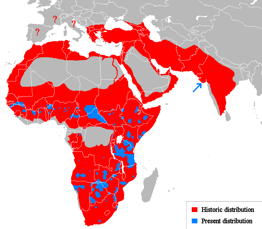
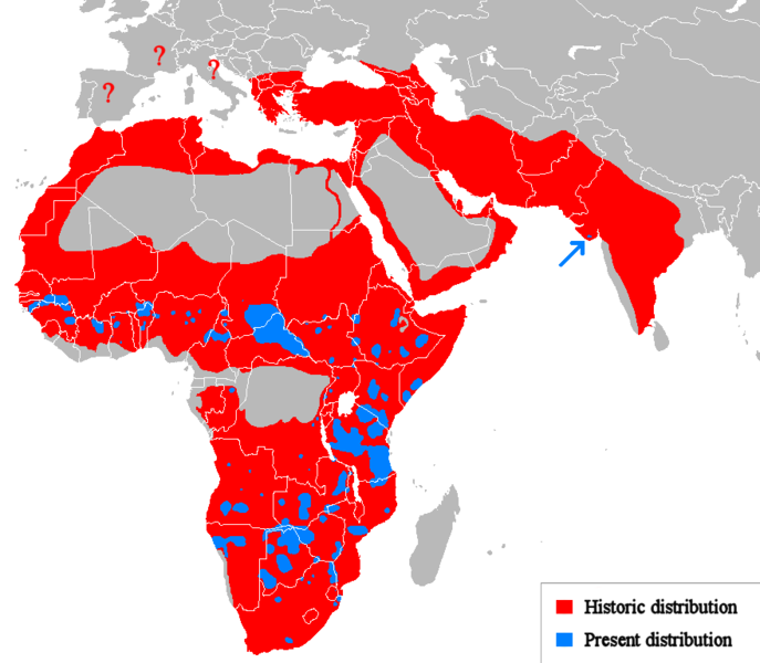
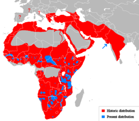
English: Geographical distribution of lions. Red (and blue) shows areas historically inhabited, blue shows areas currently inhabited.
Italiano: Areale storico (in rosso) ed attuale (in blu).
Русский: Ареал льва |
| તારીખ | (UTC) |
| સ્રોત |
Own work using:
|
| લેખક | Tommyknocker (talk) |
| અન્ય આવૃત્તિઓ | Derivative works of this file: Lion distribution-ar.png |
પરવાના
| આ રચના ના લેખક Tommyknocker at અંગ્રેજી વિકિપીડિયા દ્વારા આ રચનાને public domain હેઠળ પ્રકાશિત કરાઈ છે. આ સવલત વિશ્વવ્યપી છે અમુક દેશોમાં કાયદેસર રીતે તે શક્ય નથી, જો તેમ હોય તો : Tommyknocker દ્વારા કોઈને પણ કોઈપણ વપરાશ, કોઇ પણ શરત વગર, માટે આ રચના વાપરવાની છૂટ આપાઈ છે સિવાયકે તે શરતો કાયદેસર જરૂરી હોય. |
અસલ - મૂળ અપલોડનો લોગ
Transferred from en.wikipedia to Commons by Egmontaz using CommonsHelper.
The original description page was here. All following user names refer to en.wikipedia.
- 2009-08-26 11:21 Tommyknocker 882×770× (42518 bytes) '
- 2009-08-24 21:02 Tommyknocker 882×770× (42434 bytes) {{Information |Description = |Source = I (~~~) created this work entirely by myself. |Date = ~~~~~ |Author = ~~~ |other_versions = }}
ફાઇલનો ઇતિહાસ
તારીખ/સમય ઉપર ક્લિક કરવાથી તે સમયે ફાઇલ કેવી હતી તે જોવા મળશે.
| તારીખ/સમય | લઘુચિત્ર | પરિમાણો | સભ્ય | ટિપ્પણી | |
|---|---|---|---|---|---|
| વર્તમાન | ૧૭:૨૧, ૨૨ માર્ચ ૨૦૧૮ | | ૮૮૦ × ૭૬૮ (૫૧ KB) | Maphobbyist | Check |
| ૧૬:૫૩, ૨૨ માર્ચ ૨૦૧૮ |  | ૮૮૦ × ૭૬૮ (૫૧ KB) | Maphobbyist | South Sudan border | |
| ૦૬:૩૭, ૧૫ મે ૨૦૧૨ |  | ૮૮૦ × ૭૬૮ (૩૩ KB) | Ras67 | cropped, optimized | |
| ૧૯:૩૬, ૧૯ એપ્રિલ ૨૦૧૦ |  | ૮૮૨ × ૭૭૦ (૫૯ KB) | MPF | Change red/green to red/blue to avoid problems for viewers with red-green colourblindness | |
| ૦૧:૩૦, ૧૨ જાન્યુઆરી ૨૦૧૦ |  | ૮૮૨ × ૭૭૦ (૪૪ KB) | Tommyknocker | Distribution in Southern Europe during historical times controversial, therefore now represented with question marks. | |
| ૨૨:૩૧, ૨ નવેમ્બર ૨૦૦૯ |  | ૮૮૨ × ૭૭૦ (૪૨ KB) | File Upload Bot (Magnus Manske) | {{BotMoveToCommons|en.wikipedia|year={{subst:CURRENTYEAR}}|month={{subst:CURRENTMONTHNAME}}|day={{subst:CURRENTDAY}}}} {{Information |Description={{en|''no original description''}} |Source=Transferred from [http://en.wikipedia.org en.wikipedia]; transfer |
ફાઇલનો વપરાશ
આ ફાઇલ માં નીચેનું પાનું વપરાયેલું છે:
ફાઇલનો વ્યાપક ઉપયોગ
નીચેની બીજી વિકિઓ આ ફાઈલ વાપરે છે:
- ab.wikipedia.org પર વપરાશ
- af.wikipedia.org પર વપરાશ
- alt.wikipedia.org પર વપરાશ
- am.wikipedia.org પર વપરાશ
- ary.wikipedia.org પર વપરાશ
- arz.wikipedia.org પર વપરાશ
- ast.wikipedia.org પર વપરાશ
- as.wikipedia.org પર વપરાશ
- azb.wikipedia.org પર વપરાશ
- ban.wikipedia.org પર વપરાશ
- ba.wikipedia.org પર વપરાશ
- bcl.wikipedia.org પર વપરાશ
- be.wikipedia.org પર વપરાશ
- bg.wikipedia.org પર વપરાશ
- bh.wikipedia.org પર વપરાશ
- bn.wikipedia.org પર વપરાશ
- bs.wikipedia.org પર વપરાશ
- ca.wikipedia.org પર વપરાશ
- ca.wikiquote.org પર વપરાશ
- ceb.wikipedia.org પર વપરાશ
- ce.wikipedia.org પર વપરાશ
- ckb.wikipedia.org પર વપરાશ
- cs.wikipedia.org પર વપરાશ
- de.wikipedia.org પર વપરાશ
- de.wikibooks.org પર વપરાશ
- diq.wikipedia.org પર વપરાશ
- el.wikipedia.org પર વપરાશ
- en.wikipedia.org પર વપરાશ
- eo.wikipedia.org પર વપરાશ
- eo.wiktionary.org પર વપરાશ
- es.wikipedia.org પર વપરાશ
- es.wikibooks.org પર વપરાશ
- et.wikipedia.org પર વપરાશ
- eu.wikipedia.org પર વપરાશ
આ ફાઇલના વધુ વૈશ્વિક વપરાશ જુઓ.