
ચિત્ર:Map of current Interstates.svg

Size of this PNG preview of this SVG file: ૬૮૯ × ૪૩૨ પિક્સેલ. અન્ય આવર્તનો: ૩૨૦ × ૨૦૧ પિક્સેલ | ૬૪૦ × ૪૦૧ પિક્સેલ | ૧,૦૨૪ × ૬૪૨ પિક્સેલ | ૧,૨૮૦ × ૮૦૩ પિક્સેલ | ૨,૫૬૦ × ૧,૬૦૫ પિક્સેલ.
મૂળભુત ફાઇલ (SVG ફાઇલ, માત્ર ૬૮૯ × ૪૩૨ પીક્સલ, ફાઇલનું કદ: ૫૧૮ KB)

|
This file requires updating because: Multiple Interstates and future Interstate are Missing In doing so, you could add a timestamp to the file.
|
સારાંશ:
| વર્ણન |
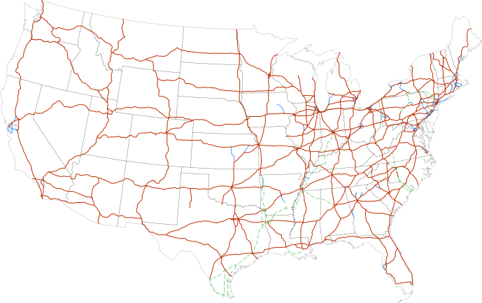
Labels:
One or Two-digit interstates (dark orange line)
Selected three-digit interstates (blue line)
Selected planned interstates (green dashed line) |
| તારીખ | |
| સ્રોત | National Atlas |
| લેખક | SPUI |
પરવાના
| આ રચના ના લેખક SPUI દ્વારા આ રચનાને public domain હેઠળ પ્રકાશિત કરાઈ છે. આ સવલત વિશ્વવ્યપી છે અમુક દેશોમાં કાયદેસર રીતે તે શક્ય નથી, જો તેમ હોય તો : |
| Annotations | This image is annotated: View the annotations at Commons |
ફાઇલનો ઇતિહાસ
તારીખ/સમય ઉપર ક્લિક કરવાથી તે સમયે ફાઇલ કેવી હતી તે જોવા મળશે.
| તારીખ/સમય | લઘુચિત્ર | પરિમાણો | સભ્ય | ટિપ્પણી | |
|---|---|---|---|---|---|
| વર્તમાન | ૧૬:૪૯, ૧૩ ફેબ્રુઆરી ૨૦૧૩ | | ૬૮૯ × ૪૩૨ (૫૧૮ KB) | Scott5114 | Add I-49 in Missouri |
| ૧૨:૦૯, ૧૧ જાન્યુઆરી ૨૦૧૩ |  | ૬૮૯ × ૪૩૨ (૫૧૯ KB) | Agricolae | add I-376 rebranding north to I-80, planned I-99 from I-80 to I-86 | |
| ૧૨:૫૭, ૨ જુલાઇ ૨૦૧૧ |  | ૬૮૯ × ૪૩૨ (૪૮૫ KB) | Jkirkuslamont | Changed hues to improve legibility for the colour blind | |
| ૧૦:૦૬, ૧૦ જાન્યુઆરી ૨૦૧૦ |  | ૬૮૯ × ૪૩૨ (૭૫૪ KB) | Techman224 | Made three-dight Interstates near Atlanta, Georgia blue | |
| ૦૩:૦૨, ૨૪ ડિસેમ્બર ૨૦૦૯ |  | ૬૮૯ × ૪૩૨ (૭૫૪ KB) | Clorox | added I69 | |
| ૧૧:૪૨, ૨૯ ફેબ્રુઆરી ૨૦૦૮ |  | ૬૮૯ × ૪૩૨ (૭૪૪ KB) | Alex43223 | Updated a couple highways | |
| ૦૮:૦૮, ૨૨ જૂન ૨૦૦૭ |  | ૬૮૯ × ૪૩૨ (૬૮૭ KB) | Fran Rogers | Reverted to earlier revision | |
| ૦૮:૦૭, ૨૨ જૂન ૨૦૦૭ |  | ૬૮૯ × ૪૩૨ (૬૮૭ KB) | Fran Rogers | {{spuimap}} Map of the present Interstate Highway System. Base map is [http://www.nationalatlas.gov/printable/images/pdf/reference/genref.pdf] (public domain US Federal Government). *Purple: two-digit *Blue: selected three-digit *Green: selected future ro | |
| ૨૧:૩૭, ૧૩ જુલાઇ ૨૦૦૬ |  | ૬૮૯ × ૪૩૨ (૬૮૭ KB) | SPUI~commonswiki | {{spuimap}} |
ફાઇલનો વપરાશ
આ ફાઇલ માં નીચેનું પાનું વપરાયેલું છે:
ફાઇલનો વ્યાપક ઉપયોગ
નીચેની બીજી વિકિઓ આ ફાઈલ વાપરે છે:
- an.wikipedia.org પર વપરાશ
- ar.wikipedia.org પર વપરાશ
- ast.wikipedia.org પર વપરાશ
- az.wikipedia.org પર વપરાશ
- bg.wikipedia.org પર વપરાશ
- bs.wikipedia.org પર વપરાશ
- ca.wikipedia.org પર વપરાશ
- da.wikipedia.org પર વપરાશ
- de.wikipedia.org પર વપરાશ
- en.wikipedia.org પર વપરાશ
- Economy of the United States
- Transportation in the United States
- List of gaps in Interstate Highways
- List of auxiliary Interstate Highways
- Controlled-access highway
- List of business routes of the Interstate Highway System
- User:Master son/US Roads
- User:Master son/US Roads/MTF
- Driving in the United States
- Trucking industry in the United States
- 1956 in the United States
- List of transport megaprojects
- User:Stephen100002/sandbox
- User:Vigneshdm1990/sandbox
- User:44Nifty/sandbox
- User:XanUltra
- Transportation policy of the United States
- Talk:United States/Archive 102
- Portal:Transport/Highway media
- Wikipedia talk:External links/Archive 42
- Wikipedia:Village pump (technical)/Archive 208
- en.wikibooks.org પર વપરાશ
- eo.wikipedia.org પર વપરાશ
- es.wikipedia.org પર વપરાશ
- et.wikipedia.org પર વપરાશ
- eu.wikipedia.org પર વપરાશ
- fa.wikipedia.org પર વપરાશ
- fi.wikipedia.org પર વપરાશ
આ ફાઇલના વધુ વૈશ્વિક વપરાશ જુઓ.