
ચિત્ર:Marshall Islands - Location Map (2013) - MHL - UNOCHA.svg

મૂળભુત ફાઇલ (SVG ફાઇલ, માત્ર ૨૫૦ × ૨૫૦ પીક્સલ, ફાઇલનું કદ: ૧,૦૧૭ KB)
_-_MHL_-_UNOCHA.svg)
સારાંશ:
| વર્ણન |
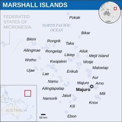
English: Locator map of Marshall Islands. |
| તારીખ | |
| સ્રોત | |
| લેખક | |
| SVG genesis |
પરવાના
- તમે મુક્ત છો:
- વહેંચવા – નકલ કરવા, વિતરણ કરવા અને રચનાઓ મોકલવા
- રીમિક્સ કરવા કે મઠારવા – રચના અપનાવવા
- નીચેની શરત હેઠળ:
- આરોપણ – તમારે આ રચનાનો ઉપયોગ કરવા માટે લેખક કે પ્રકાશન અધિકાર ધારકની યોગ્ય માહિતી, પરવાનગી (લાયસન્સ)ની કડી અને તેમાં ફેરફાર કર્યો હોય તો તેનો ઉલ્લેખ કરવો જ પડશે. તમે આ સત્તા અનુસાર જ આ રચનાનો પ્રયોગ થવો જોઈએ, પણ તેઓ તમને અથવા તમારા ઉપયોગ સાથે સંમત થાય છે તે રીતે નહીં.
 This map is part of a collection of 216 free country maps, created by the UN Office for the Coordination of Humanitarian Affairs (OCHA), to be used in print, web or broadcast products.
The ReliefWeb Location Maps released here are maps that highlight a country, its capital, major populated places and the surrounding regions. Attribution Requirements
Using the map without modifications: ensure that the sources and the disclaimer are below the map. Credit as follows: "Credit: OCHA". For use with alteration: remove the OCHA logo and disclaimer following any modification to the map, but keep the data sources as mentioned below the map. Credit the modified map as follows: "Based on OCHA map". You are responsible for the content of your map. We are keen to receive your feedback and hear how you used OCHA's maps. We would be grateful if you would notify us by e-mail and share your work with us. UN Disclaimer
The designations employed and the presentation of material of this map do not imply the expression of any opinion whatsoever on the part of the Secretariat of the United Nations concerning the legal status of any country, territory, city or area or of its authorities or concerning the delimitation of its frontiers or boundaries. |
ફાઇલનો ઇતિહાસ
તારીખ/સમય ઉપર ક્લિક કરવાથી તે સમયે ફાઇલ કેવી હતી તે જોવા મળશે.
| તારીખ/સમય | લઘુચિત્ર | પરિમાણો | સભ્ય | ટિપ્પણી | |
|---|---|---|---|---|---|
| વર્તમાન | ૦૭:૨૪, ૨૯ ડિસેમ્બર ૨૦૨૨ | | ૨૫૦ × ૨૫૦ (૧,૦૧૭ KB) | Wikijahnn | File uploaded using svgtranslate tool (https://svgtranslate.toolforge.org/). Added translation for ca. |
| ૧૨:૦૭, ૭ સપ્ટેમ્બર ૨૦૧૬ |  | ૨૫૦ × ૨૫૦ (૧,૦૧૪ KB) | Wereldburger758 | Resized page to drawing. Removal watermark. Validation of image. | |
| ૦૫:૨૧, ૮ મે ૨૦૧૪ |  | ૨૫૪ × ૨૫૪ (૯૯૬ KB) | UN OCHA maps bot | == {{int:filedesc}} == {{Information |description={{en|1=Locator map of Marshall Islands.}} |date=2013 |source={{en|1=[http://reliefweb.int/map/marshall-islands/marshall-islands-location-map-2013 Marshall Islands Locator Map (... |
ફાઇલનો વપરાશ
આ ફાઇલ માં નીચેનું પાનું વપરાયેલું છે:
ફાઇલનો વ્યાપક ઉપયોગ
નીચેની બીજી વિકિઓ આ ફાઈલ વાપરે છે:
- bh.wikipedia.org પર વપરાશ
- bn.wikipedia.org પર વપરાશ
- ca.wikipedia.org પર વપરાશ
- da.wikipedia.org પર વપરાશ
- de.wikivoyage.org પર વપરાશ
- fa.wikipedia.org પર વપરાશ
- id.wikipedia.org પર વપરાશ
- no.wikipedia.org પર વપરાશ
- sat.wikipedia.org પર વપરાશ
- sr.wikipedia.org પર વપરાશ
_-_MHL_-_UNOCHA.svg)