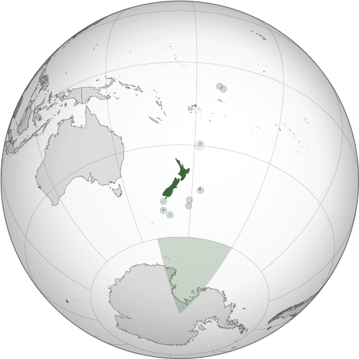
ચિત્ર:NZL orthographic NaturalEarth.svg

Size of this PNG preview of this SVG file: ૫૧૨ × ૫૧૨ પિક્સેલ. અન્ય આવર્તનો: ૨૪૦ × ૨૪૦ પિક્સેલ | ૪૮૦ × ૪૮૦ પિક્સેલ | ૭૬૮ × ૭૬૮ પિક્સેલ | ૧,૦૨૪ × ૧,૦૨૪ પિક્સેલ | ૨,૦૪૮ × ૨,૦૪૮ પિક્સેલ.
મૂળભુત ફાઇલ (SVG ફાઇલ, માત્ર ૫૧૨ × ૫૧૨ પીક્સલ, ફાઇલનું કદ: ૫૭૪ KB)
ફાઇલનો ઇતિહાસ
તારીખ/સમય ઉપર ક્લિક કરવાથી તે સમયે ફાઇલ કેવી હતી તે જોવા મળશે.
| તારીખ/સમય | લઘુચિત્ર | પરિમાણો | સભ્ય | ટિપ્પણી | |
|---|---|---|---|---|---|
| વર્તમાન | ૦૩:૩૬, ૧ નવેમ્બર ૨૦૧૩ |  | ૫૧૨ × ૫૧૨ (૫૭૪ KB) | TooncesB | == Summary == {{Information |Description={{en|1=A map of the hemisphere centred on Wellington, New Zealand, using an orthographic projection, created using gringer's Perl script with [http://www.naturalear... |
| ૦૫:૨૨, ૬ ઓક્ટોબર ૨૦૧૩ |  | ૫૫૩ × ૫૫૩ (૫૦૫ KB) | TooncesB | {{Information |Description={{en|1=A map of the hemisphere centred on Wellington, New Zealand, using an orthographic projection, created using gringer's Perl script with [http://www.naturalearthdata.com/ Na... | |
| ૧૮:૫૨, ૨ ઓક્ટોબર ૨૦૧૩ |  | ૫૫૩ × ૫૫૩ (૫૦૪ KB) | TooncesB | {{Information |Description={{en|1=A map of the hemisphere centred on Wellington, New Zealand, using an orthographic projection, created using gringer's Perl script with [http://www.naturalearthdata.com/ Na... | |
| ૦૧:૩૭, ૨ ઓક્ટોબર ૨૦૧૩ |  | ૫૫૩ × ૫૫૩ (૫૫૬ KB) | TooncesB | {{Information |Description={{en|1=A map of the hemisphere centred on Wellington, New Zealand, using an orthographic projection, created using gringer's Perl script with [http://www.naturalearthdata.com/ Na... | |
| ૨૦:૧૧, ૧ મે ૨૦૧૩ |  | ૫૫૩ × ૫૫૩ (૫૫૮ KB) | Gringer | Updated generation script (still needs some Inkscape hand-holding). Slightly larger image. Used high-resolution (10m) shapes for all countries, added highlight circles and Antarctica claim. | |
| ૧૦:૦૫, ૧ સપ્ટેમ્બર ૨૦૧૦ |  | ૫૫૦ × ૫૫૦ (૩૯૮ KB) | Gringer | Using high resolution (10m) shapes for New Zealand, removed odd Antarctica spike. | |
| ૦૪:૪૩, ૩૧ ઓગસ્ટ ૨૦૧૦ |  | ૫૫૦ × ૫૫૦ (૨૫૦ KB) | Gringer | changed size to fit with recommendations, white sea | |
| ૦૪:૨૪, ૩૧ ઓગસ્ટ ૨૦૧૦ |  | ૧,૦૫૦ × ૧,૦૫૦ (૨૪૯ KB) | Gringer | {{Information |Description={{en|1=A map of the hemisphere centred on Wellington, New Zealand, using an orthographic projection, created using gringer's [[[w:User:Gringer/perlshaper|Perl script] with [http://www.naturalearthdata.com/ Natur |
ફાઇલનો વપરાશ
આ ફાઇલ માં નીચેનું પાનું વપરાયેલું છે:
ફાઇલનો વ્યાપક ઉપયોગ
નીચેની બીજી વિકિઓ આ ફાઈલ વાપરે છે:
- ace.wikipedia.org પર વપરાશ
- ami.wikipedia.org પર વપરાશ
- ar.wikipedia.org પર વપરાશ
- as.wikipedia.org પર વપરાશ
- azb.wikipedia.org પર વપરાશ
- bg.wikipedia.org પર વપરાશ
- bh.wikipedia.org પર વપરાશ
- bn.wikipedia.org પર વપરાશ
- bs.wikipedia.org પર વપરાશ
- cdo.wikipedia.org પર વપરાશ
- ceb.wikipedia.org પર વપરાશ
- ckb.wikipedia.org પર વપરાશ
- cs.wikipedia.org પર વપરાશ
- da.wikipedia.org પર વપરાશ
- diq.wikipedia.org પર વપરાશ
- ee.wikipedia.org પર વપરાશ
- el.wikipedia.org પર વપરાશ
- en.wikipedia.org પર વપરાશ
- Portal:New Zealand
- User talk:Gringer
- New Zealand
- User:LJ Holden/dreams
- The Amazing Race 22
- User:J4kob123/sandbox
- User:Lbothwe/New Zealand
- User:Artemis Andromeda/sandbox/WikiBelta/Zealand Nuva
- Talk:List of guests at the state funeral of Elizabeth II
- Installations of the United States Navy in New Zealand
- en.wikibooks.org પર વપરાશ
- en.wiktionary.org પર વપરાશ
- es.wikipedia.org પર વપરાશ
- eu.wikipedia.org પર વપરાશ
- fa.wikipedia.org પર વપરાશ
- fi.wikipedia.org પર વપરાશ
- fj.wikipedia.org પર વપરાશ
- fr.wikipedia.org પર વપરાશ
- gl.wikipedia.org પર વપરાશ
- gn.wikipedia.org પર વપરાશ
- hak.wikipedia.org પર વપરાશ
- hif.wikipedia.org પર વપરાશ
- hi.wikipedia.org પર વપરાશ
- hr.wikipedia.org પર વપરાશ
- id.wikipedia.org પર વપરાશ
- id.wikibooks.org પર વપરાશ
આ ફાઇલના વધુ વૈશ્વિક વપરાશ જુઓ.


