
ચિત્ર:National-atlas-louisiana.png
આથી વધુ ઘનત્વ ઉપલબ્ધ નથી.
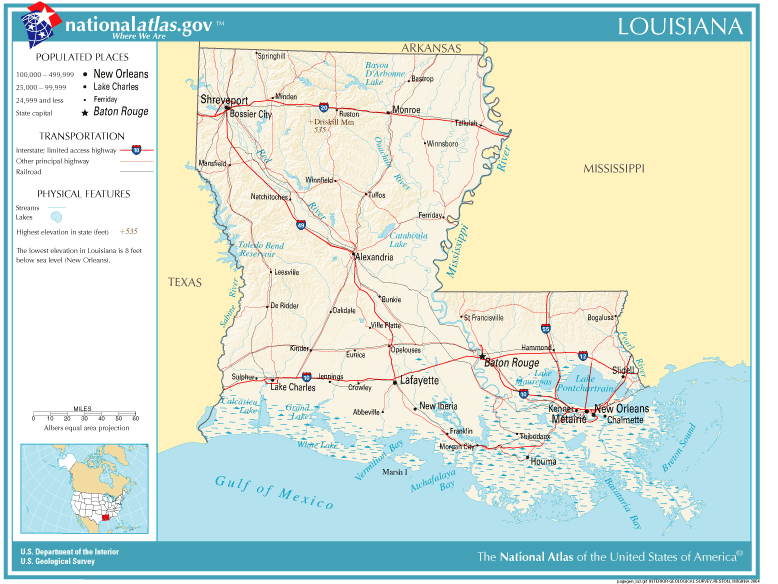
National-atlas-louisiana.png (૭૭૮ × ૫૮૪ પીક્સલ, ફાઇલનું કદ: ૧૧૭ KB, MIME પ્રકાર: image/png)
સારાંશ:
| વર્ણન | Louisiana map |
| સ્રોત | Originally from Image%3ANational-atlas-louisiana.PNG. |
| લેખક |
પરવાના
This map was obtained from an edition of the National Atlas of the United States. Like almost all works of the U.S. federal government, works from the National Atlas are in the public domain in the United States.
Online access: NationalAtlas.gov | 1970 print edition: Library of Congress, Perry-Castañeda Library
|
Wikipedia upload log
(All user names refer to en.wikipedia)
- 2004-11-05 01:28 Queson 778×584×8 (120201 bytes) National Atlas map of Louisiana {{PD-USGov}}
ફાઇલનો ઇતિહાસ
તારીખ/સમય ઉપર ક્લિક કરવાથી તે સમયે ફાઇલ કેવી હતી તે જોવા મળશે.
| તારીખ/સમય | લઘુચિત્ર | પરિમાણો | સભ્ય | ટિપ્પણી | |
|---|---|---|---|---|---|
| વર્તમાન | ૧૭:૩૫, ૯ મે ૨૦૦૭ | | ૭૭૮ × ૫૮૪ (૧૧૭ KB) | Hbk33 | {{Information |Description=en:Category:Louisiana maps |Source=Originally from [http://en.wikipedia.org en.wikipedia]; description page is/was [http://en.wikipedia.org/w/index.php?title=Image%3ANational-atlas-louisiana.PNG here]. |Date=2004-11-05 (ori |
ફાઇલનો વપરાશ
આ ફાઇલ માં નીચેનું પાનું વપરાયેલું છે:
ફાઇલનો વ્યાપક ઉપયોગ
નીચેની બીજી વિકિઓ આ ફાઈલ વાપરે છે:
- ar.wikipedia.org પર વપરાશ
- en.wikivoyage.org પર વપરાશ
- eu.wikipedia.org પર વપરાશ
- fr.wikipedia.org પર વપરાશ
- he.wikipedia.org પર વપરાશ
- hr.wiktionary.org પર વપરાશ
- ja.wikipedia.org પર વપરાશ
- kn.wikipedia.org પર વપરાશ
- nl.wikipedia.org પર વપરાશ
- pam.wikipedia.org પર વપરાશ
- pl.wikivoyage.org પર વપરાશ
- ro.wikipedia.org પર વપરાશ
- sw.wikipedia.org પર વપરાશ
- tr.wikipedia.org પર વપરાશ
- zh-yue.wikipedia.org પર વપરાશ