
ચિત્ર:Orbitalaltitudes.jpg
આ પૂર્વાવલોકનનું કદ: ૭૯૯ × ૨૯૪ પિક્સેલ. અન્ય આવર્તનો: ૩૨૦ × ૧૧૮ પિક્સેલ | ૬૪૦ × ૨૩૬ પિક્સેલ | ૧,૦૨૪ × ૩૭૭ પિક્સેલ | ૧,૨૮૦ × ૪૭૧ પિક્સેલ | ૪,૫૦૦ × ૧,૬૫૬ પિક્સેલ.
મૂળભુત ફાઇલ (૪,૫૦૦ × ૧,૬૫૬ પીક્સલ, ફાઇલનું કદ: ૮૮૪ KB, MIME પ્રકાર: image/jpeg)
સારાંશ:
| વર્ણન |
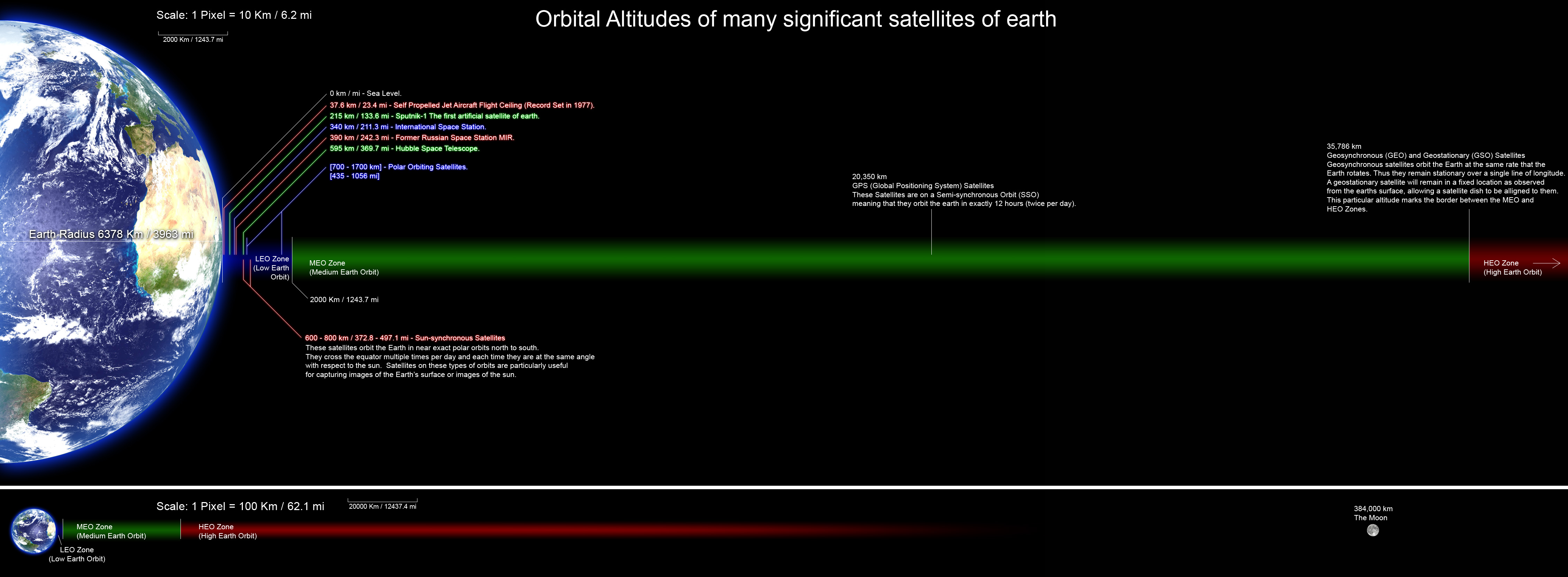
English: A perfectly scaled diagram showing the orbital altitudes of several significant satellites of earth. all planets and orbital distances are drawn to scale and the altitude data was collected from many Wikipedia articles and various other sites. |
| તારીખ | |
| સ્રોત | પોતાની રચના |
| લેખક | Rrakanishu |

|
File:Orbitalaltitudes.svg is a vector version of this file. It should be used in place of this JPG file when not inferior.
File:Orbitalaltitudes.jpg → File:Orbitalaltitudes.svg
For more information, see Help:SVG. |
 |
પરવાના
હું, આ કાર્યનો પ્રકાશનાધિકાર ધારક, તેને નીચેના પરવાનાઓ હેઠળ અહીં પ્રકાશીત કરૂં છું:

|
આ રચનાની નકલ કરવા, વિતરણ અને સુધારો કરવા માટે GNU Free Documentation License, આવૃત્તિ 1.2 કે અન્ય આગળની આવૃત્તિ Free Software Foundation હેઠળ પરવાનગી છે; જેમાં કોઈ Invariant Sections, no Front-Cover Texts, and no Back-Cover Texts નથી. આ પરવાનાની પ્રત GNU Free Documentation License વિભાગમાં છે. |
This file is licensed under the Creative Commons Attribution-Share Alike 4.0 International, 3.0 Unported, 2.5 Generic, 2.0 Generic and 1.0 Generic license.
- તમે મુક્ત છો:
- વહેંચવા – નકલ કરવા, વિતરણ કરવા અને રચનાઓ મોકલવા
- રીમિક્સ કરવા કે મઠારવા – રચના અપનાવવા
- નીચેની શરત હેઠળ:
- આરોપણ – તમારે આ રચનાનો ઉપયોગ કરવા માટે લેખક કે પ્રકાશન અધિકાર ધારકની યોગ્ય માહિતી, પરવાનગી (લાયસન્સ)ની કડી અને તેમાં ફેરફાર કર્યો હોય તો તેનો ઉલ્લેખ કરવો જ પડશે. તમે આ સત્તા અનુસાર જ આ રચનાનો પ્રયોગ થવો જોઈએ, પણ તેઓ તમને અથવા તમારા ઉપયોગ સાથે સંમત થાય છે તે રીતે નહીં.
- શેર- અલાઈક (બિન ભેદભાવ વહેંચણી) – તમે જો આ રચનાને બદલશો, તેમાં ફેરફાર કરશો અથવા તેના પર આધારિત કોઇ કાર્ય બનાવશો તો તમારે પરિણામી કાર્યને તે જ અથવા અનુરૂપ પરવાનગી હેઠળ જ પ્રકાશિત કરવું પડશે.
તમે તમારી પસંદગીનો પરવાનો પસંદ કરી શકો છો.
ફાઇલનો ઇતિહાસ
તારીખ/સમય ઉપર ક્લિક કરવાથી તે સમયે ફાઇલ કેવી હતી તે જોવા મળશે.
| તારીખ/સમય | લઘુચિત્ર | પરિમાણો | સભ્ય | ટિપ્પણી | |
|---|---|---|---|---|---|
| વર્તમાન | ૧૭:૪૩, ૨૫ ઓગસ્ટ ૨૦૧૧ | ૪,૫૦૦ × ૧,૬૫૬ (૮૮૪ KB) | Rrakanishu | Corrected Typo's | |
| ૨૩:૪૫, ૨૪ ઓગસ્ટ ૨૦૧૧ | ૪,૫૦૦ × ૧,૬૫૬ (૮૮૪ KB) | Rrakanishu | Added a visual scale to both sections Color coded the items in LEO zone so that its easier to follow the lines. Added some more information. | ||
| ૧૪:૦૮, ૧૨ ઓગસ્ટ ૨૦૧૦ | ૪,૫૦૦ × ૧,૬૫૬ (૧.૦૨ MB) | IdLoveOne~commonswiki | better contrast on Earth 3 | ||
| ૧૨:૧૬, ૧૨ ઓગસ્ટ ૨૦૧૦ | ૪,૫૦૦ × ૧,૬૫૬ (૧.૦૨ MB) | IdLoveOne~commonswiki | Added conversions and fixed "longitude" | ||
| ૦૦:૫૫, ૧૦ જૂન ૨૦૦૮ | ૪,૫૦૦ × ૧,૬૫૬ (૫૩૦ KB) | Rrakanishu | {{Information |Description={{en|1=Perfect scaled diagram showing the orbital altitudes of several significant satellites of earth. all planets and orbital distances are drawn to scale and the altitude data was collected from many wikipedia articles and va | ||
| ૦૦:૪૭, ૧૦ જૂન ૨૦૦૮ | ૪,૫૦૦ × ૧,૬૫૬ (૫૦૭ KB) | Rrakanishu | {{Information |Description={{en|1=Perfect scaled diagram showing the orbital altitudes of several significant satellites of earth. all planets and orbital distances are drawn to scale and the altitude data was collected from many wikipedia articles and v |
ફાઇલનો વપરાશ
આ ફાઇલ માં નીચેનું પાનું વપરાયેલું છે:
ફાઇલનો વ્યાપક ઉપયોગ
નીચેની બીજી વિકિઓ આ ફાઈલ વાપરે છે:
- ar.wikipedia.org પર વપરાશ
- bn.wikipedia.org પર વપરાશ
- ca.wikipedia.org પર વપરાશ
- en.wikipedia.org પર વપરાશ
- Medium Earth orbit
- Wikipedia:Valued picture candidates/File:Orbitalaltitudes.jpg
- Wikipedia:Valued picture candidates/August-2010
- Human presence in space
- User talk:IdLoveOne/Archive 1
- Wikipedia:Featured picture candidates/Orbital Altitudes
- Wikipedia:Featured picture candidates/September-2011
- Talk:Satellite/Archive 1
- Space Development Agency
- es.wikipedia.org પર વપરાશ
- et.wikipedia.org પર વપરાશ
- fa.wikipedia.org પર વપરાશ
- he.wikipedia.org પર વપરાશ
- hi.wikipedia.org પર વપરાશ
- hy.wikipedia.org પર વપરાશ
- id.wikipedia.org પર વપરાશ
- it.wikipedia.org પર વપરાશ
- ja.wikipedia.org પર વપરાશ
- kk.wikipedia.org પર વપરાશ
- lt.wikipedia.org પર વપરાશ
- mk.wikipedia.org પર વપરાશ
- ml.wikipedia.org પર વપરાશ
- ms.wikipedia.org પર વપરાશ
- ne.wikipedia.org પર વપરાશ
- pt.wikipedia.org પર વપરાશ
- ro.wikibooks.org પર વપરાશ
- ru.wikipedia.org પર વપરાશ
- sh.wikipedia.org પર વપરાશ
- sl.wikipedia.org પર વપરાશ
- sr.wikipedia.org પર વપરાશ
- ta.wikipedia.org પર વપરાશ
- te.wikipedia.org પર વપરાશ
આ ફાઇલના વધુ વૈશ્વિક વપરાશ જુઓ.