
ચિત્ર:Percentage population undernourished world map.PNG

આ પૂર્વાવલોકનનું કદ: ૮૦૦ × ૩૬૨ પિક્સેલ. અન્ય આવર્તનો: ૩૨૦ × ૧૪૫ પિક્સેલ | ૬૪૦ × ૨૮૯ પિક્સેલ | ૧,૨૩૭ × ૫૫૯ પિક્સેલ.
મૂળભુત ફાઇલ (૧,૨૩૭ × ૫૫૯ પીક્સલ, ફાઇલનું કદ: ૧૬૧ KB, MIME પ્રકાર: image/png)
સારાંશ:
| વર્ણન |
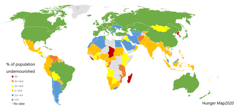
English: List of countries by percentage of population suffering from undernourishment. Made by jp:User:Fnweirkmnwperojvnu, using Map of Excel. The map has been updated (on 2021-01-11) according to the "Hunger Map 2020" from the United Nations World Food Programme.
Sources: Sustainable Development Goal indicators website "Global SDG Indicators Database>GOLE2 End hunger, achieve food security and improved nutrition and promote sustainable agriculture": https://unstats.un.org/sdgs/indicators/database/?indicator=2.1.1 United Nations World Food Programme's interactive "hunger map": http://cdn.wfp.org/hungermap/ Hunger Map 2020: https://www.wfp.org/publications/hunger-map-2020 |
| તારીખ | ૧૧ જાન્યુઆરી ૨૦૨૧ (original upload date) |
| સ્રોત | Transferred from en.wikipedia to Commons. |
| લેખક | The original uploader was Fnweirkmnwperojvnu at jp વિકિપીડિયા. |
| અન્ય આવૃત્તિઓ |
Derivative works of this file: Percentage population undernourished world map-ar.PNG  |


|
This map image could be re-created using vector graphics as an SVG file. This has several advantages; see Commons:Media for cleanup for more information. If an SVG form of this image is available, please upload it and afterwards replace this template with
{{vector version available|new image name}}.
It is recommended to name the SVG file “Percentage population undernourished world map.svg”—then the template Vector version available (or Vva) does not need the new image name parameter. |
પરવાના

|
આ રચનાની નકલ કરવા, વિતરણ અને સુધારો કરવા માટે GNU Free Documentation License, આવૃત્તિ 1.2 કે અન્ય આગળની આવૃત્તિ Free Software Foundation હેઠળ પરવાનગી છે; જેમાં કોઈ Invariant Sections, no Front-Cover Texts, and no Back-Cover Texts નથી. આ પરવાનાની પ્રત GNU Free Documentation License વિભાગમાં છે. |
| આ ફાઈલ વપરાશની પરવાનગી : Creative Commons Attribution-Share Alike 3.0 Unported license. | ||
| ||
| GFDL licensing update ના ભાગ રૂપે આ પરવાનાનો ટેગ ફાઈલ પર લગાડવામાં આવ્યો છે. |
અસલ - મૂળ અપલોડનો લોગ
The original description page was here. All following user names refer to en.wikipedia.
- 2007-03-23 02:31 Lobizón 1355×768×8 (58226 bytes) List of countries by percentage of population suffering from undernourishment. Made from Wikipedia's "map of the world" template, using information from the United Nations World Food Programme and the FAO "The State of Food Insecurity in the World 2006" r
ફાઇલનો ઇતિહાસ
તારીખ/સમય ઉપર ક્લિક કરવાથી તે સમયે ફાઇલ કેવી હતી તે જોવા મળશે.
| તારીખ/સમય | લઘુચિત્ર | પરિમાણો | સભ્ય | ટિપ્પણી | |
|---|---|---|---|---|---|
| વર્તમાન | ૨૨:૦૧, ૧૦ જાન્યુઆરી ૨૦૨૧ | | ૧,૨૩૭ × ૫૫૯ (૧૬૧ KB) | Fnweirkmnwperojvnu | data updates |
| ૦૨:૩૭, ૧૯ જુલાઇ ૨૦૨૦ |  | ૧,૩૫૭ × ૬૨૮ (૪૭ KB) | Maphobbyist | South Sudan border | |
| ૦૦:૦૦, ૧૭ એપ્રિલ ૨૦૧૬ |  | ૧,૩૫૭ × ૬૨૮ (૪૬ KB) | Kontrollstellekundl | updated according to the "Hunger Map 2013" http://documents.wfp.org/stellent/groups/public/documents/communications/wfp229327.pdf | |
| ૧૭:૫૦, ૨૮ ફેબ્રુઆરી ૨૦૧૬ |  | ૧,૩૫૭ × ૬૨૮ (૪૫ KB) | Kontrollstellekundl | cropped | |
| ૧૯:૩૮, ૧૫ ઓગસ્ટ ૨૦૧૫ |  | ૧,૩૫૫ × ૭૬૮ (૪૬ KB) | Jamie Tubers | update | |
| ૧૦:૦૮, ૩૧ ડિસેમ્બર ૨૦૧૩ |  | ૧,૩૫૫ × ૭૬૮ (૫૬ KB) | Varitia | Small correction on Indonesia | |
| ૦૯:૪૯, ૩૧ ડિસેમ્બર ૨૦૧૩ |  | ૧,૩૫૫ × ૭૬૮ (૫૬ KB) | Varitia | Update to 2012 figures and parameters according to the United Nations World Food Programme | |
| ૦૪:૩૪, ૫ મે ૨૦૦૮ |  | ૧,૩૫૫ × ૭૬૮ (૫૬ KB) | Dwrcan | Updates. (Note: click on the actual countries of the source map, the actual data sometimes doesn't match the color of the country.) | |
| ૦૨:૩૦, ૧૧ નવેમ્બર ૨૦૦૭ |  | ૧,૩૫૫ × ૭૬૮ (૫૭ KB) | Béka~commonswiki | {{Information |Description={{en|List of countries by percentile of population suffering from undernourishment. Made by en:User:Lobizón, using Wikipedia's "map of the world" template, and information from the United Nations World Food Programme and t |
ફાઇલનો વપરાશ
આ ફાઇલ માં નીચેનું પાનું વપરાયેલું છે:
ફાઇલનો વ્યાપક ઉપયોગ
નીચેની બીજી વિકિઓ આ ફાઈલ વાપરે છે:
- af.wikipedia.org પર વપરાશ
- ast.wikipedia.org પર વપરાશ
- ba.wikipedia.org પર વપરાશ
- bg.wikipedia.org પર વપરાશ
- bn.wikipedia.org પર વપરાશ
- cs.wikipedia.org પર વપરાશ
- cv.wikipedia.org પર વપરાશ
- de.wikipedia.org પર વપરાશ
- en.wikipedia.org પર વપરાશ
- en.wikinews.org પર વપરાશ
- eo.wikipedia.org પર વપરાશ
- es.wikipedia.org પર વપરાશ
- es.wikinews.org પર વપરાશ
- eu.wikipedia.org પર વપરાશ
- fa.wikipedia.org પર વપરાશ
- fi.wikipedia.org પર વપરાશ
- fy.wikipedia.org પર વપરાશ
- he.wikipedia.org પર વપરાશ
- hr.wikipedia.org પર વપરાશ
- hu.wikipedia.org પર વપરાશ
- hy.wikipedia.org પર વપરાશ
- id.wikipedia.org પર વપરાશ
- is.wikipedia.org પર વપરાશ
- it.wikipedia.org પર વપરાશ
- ja.wikipedia.org પર વપરાશ
- kn.wikipedia.org પર વપરાશ
- la.wikipedia.org પર વપરાશ
- lmo.wikipedia.org પર વપરાશ
- lt.wikipedia.org પર વપરાશ
- lv.wikipedia.org પર વપરાશ
આ ફાઇલના વધુ વૈશ્વિક વપરાશ જુઓ.