
ચિત્ર:United Kingdom labelled map7.png

આ પૂર્વાવલોકનનું કદ: ૩૫૮ × ૫૯૯ પિક્સેલ. અન્ય આવર્તનો: ૧૪૩ × ૨૪૦ પિક્સેલ | ૨૮૭ × ૪૮૦ પિક્સેલ | ૬૪૩ × ૧,૦૭૫ પિક્સેલ.
મૂળભુત ફાઇલ (૬૪૩ × ૧,૦૭૫ પીક્સલ, ફાઇલનું કદ: ૮૬ KB, MIME પ્રકાર: image/png)

|
File:United Kingdom labelled map7 vector.svg is a vector version of this file. It should be used in place of this PNG file when not inferior.
File:United Kingdom labelled map7.png → File:United Kingdom labelled map7 vector.svg
For more information, see Help:SVG. |
 |
સારાંશ:
| વર્ણન |
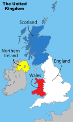
English: Divisions of the United Kingdom |
||
| તારીખ | ૧૭ જુલાઇ ૨૦૦૮ (original upload date) | ||
| સ્રોત |
પોતાની રચના by Matt Lewis derived from: File:Uk map home nations.png |
||
| લેખક | Amended Wikipedia image - amended by Matt Lewis for Wikipedia. | ||
| પરવાનગી (આ ફાઈલનો ફરી ઉપયોગ) |
Matt Lewis, આ કાર્યનો પ્રકાશનાધિકાર ધારક, તેને નીચેના પરવાનાઓ હેઠળ અહીં પ્રકાશીત કરે છે: આ ફાઈલ વપરાશની પરવાનગી : Creative Commons Attribution-Share Alike 3.0 Unported license. આરોપણ: Matt Lewis
તમે તમારી પસંદગીનો પરવાનો પસંદ કરી શકો છો. |
||
| અન્ય આવૃત્તિઓ |
|

અસલ - મૂળ અપલોડનો લોગ
The original description page was on en.wikipedia (log). All following user names refer to en.wikipedia.
- 17:17, 1 December 2008 Ddstretch 643×1,075 (86 KB) (Reverted to version as of 02:16, 17 July 2008- colors as used were agreed upon by consensus, and green is clearly too political to stay)
- 16:35, 1 December 2008 Roadnote 643×1,075 (72 KB) (Original by [[User:Matt Lewis|Matt Lewis]] ([[User talk:Matt Lewis|talk]]) - Northern Ireland changed from yellow to green by ~~~~ {{ShouldBeSVG}})
- 02:16, 17 July 2008 Matt Lewis 643×1,075 (86 KB) (Amended Wikipedia image - amended by [[User:Matt Lewis|Matt Lewis]] for Wikipedia.)
ફાઇલનો ઇતિહાસ
તારીખ/સમય ઉપર ક્લિક કરવાથી તે સમયે ફાઇલ કેવી હતી તે જોવા મળશે.
| તારીખ/સમય | લઘુચિત્ર | પરિમાણો | સભ્ય | ટિપ્પણી | |
|---|---|---|---|---|---|
| વર્તમાન | ૦૩:૨૯, ૯ ડિસેમ્બર ૨૦૧૩ | | ૬૪૩ × ૧,૦૭૫ (૮૬ KB) | Chronus | Reverted to version as of 20:04, 7 December 2013 |
| ૦૧:૩૫, ૮ ડિસેમ્બર ૨૦૧૩ |  | ૬૪૩ × ૧,૦૭૫ (૫૧૬ KB) | Boonstiffs | Reverted to version as of 20:03, 7 December 2013 | |
| ૦૧:૩૪, ૮ ડિસેમ્બર ૨૦૧૩ |  | ૬૪૩ × ૧,૦૭૫ (૮૬ KB) | Boonstiffs | Reverted to version as of 05:59, 27 October 2013 | |
| ૦૧:૩૩, ૮ ડિસેમ્બર ૨૦૧૩ |  | ૬૪૩ × ૧,૦૭૫ (૫૧૬ KB) | Boonstiffs | Reverted to version as of 12:59, 26 October 2013 | |
| ૧૧:૨૯, ૨૭ ઓક્ટોબર ૨૦૧૩ |  | ૬૪૩ × ૧,૦૭૫ (૮૬ KB) | Tóraí | Reverted to version as of 11:31, 12 July 2009; map is used on articles relating to the 4 "countries of the United Kingdom", where Cornwall isn't usually considered one | |
| ૧૮:૨૯, ૨૬ ઓક્ટોબર ૨૦૧૩ |  | ૬૪૩ × ૧,૦૭૫ (૫૧૬ KB) | Mownberry | Cornwall added. | |
| ૧૭:૦૧, ૧૨ જુલાઇ ૨૦૦૯ |  | ૬૪૩ × ૧,૦૭૫ (૮૬ KB) | Chronus | == Summary == {{Information |Description=Divisions of the United Kingdom |Source=originally uploaded to :en at en:File:United Kingdom labelled map7.png |Date= |Author= Amended Wikipedia image - amended by Matt Lewis for Wikipe |
ફાઇલનો વપરાશ
આ ફાઇલને કોઇ પાનાં વાપરતા નથી.
ફાઇલનો વ્યાપક ઉપયોગ
નીચેની બીજી વિકિઓ આ ફાઈલ વાપરે છે:
- en.wikipedia.org પર વપરાશ