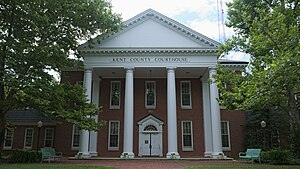
Kent County
county in Maryland, United States
સ્થાપન દિવસ / રચના દિવસ
૧૬ ડિસેમ્બર 1642[૧૨]
પરથી નામકરણ થયેલ
કેન્ટ[૨૦]
સમય વિભાગ
Eastern Time Zone
UTC−05:00
valid in period: standard time
UTC−04:00
valid in period: daylight saving time
સ્થળના અક્ષાંસ રેખાંશ
વસ્તી / જનસંખ્યા
૧૯,૧૯૮[૨૨]
determination method: census
statement is subject of: 2020 United States Census
સમય બિંદુ: ૧ એપ્રિલ 2020
water as percent of area
૩૩ percent
સરહદ દ્વારા જોડાયેલ
New Castle County[૧૫]
Kent County[૧૫]
Anne Arundel County[૧૫]
Harford County[૧૫]
Baltimore County[૧૫]
ક્ષેત્રફળ
૧,૦૭૩ square kilometre
અધિકૃત વેબસાઇટ
list of monuments
National Register of Historic Places listings in Kent County, Maryland
school district
Kent County Public Schools[૨૩]
ઘરોની સંખ્યા
૮,૨૭૪±૨૭૫[૨૪]
determination method: survey methodology
statement supported by: 2016–2020 American Community Survey
સમય બિંદુ: ૩૧ ડિસેમ્બર 2020
per capita income
૩૭,૬૯૯ United States dollar[૨૫]
determination method: survey methodology
statement supported by: 2016–2020 American Community Survey
સમય બિંદુ: ૩૧ ડિસેમ્બર 2020
FAQ URL
official map URL
https://www.roads.maryland.gov/Town_Gridmaps/100000_Kent.pdf[૨૬]
પ્રકાશક: Maryland State Highway Administration, Federal Highway Administration
ભાષા: અંગ્રેજી
પ્રકાશનનો સમય: 2022
શીર્ષક: General Highway Map of Kent County Maryland
applies to part: highway
NCI Thesaurus ID
C108894
થી જુદું
Kent County
Kent County
Kent County
Kent County
કોમન્સ શ્રેણી
Kent County, Maryland
topic's main template
Template:Kent County, Maryland
વિષયની મુખ્ય શ્રેણી
Category:Kent County, Maryland
સંબંધિત લોકોની શ્રેણી
Category:People from Kent County, Maryland
અહીં જન્મેલા લોકોની શ્રેણી
Category:Births in Kent County, Maryland
category for people who died here
Category:Deaths in Kent County, Maryland
category for maps
Category:Maps of Kent County, Maryland
સંદર્ભ
- ↑ ૧.૦ ૧.૧ ૧.૨ ૧.૩ Virtual International Authority File, ૧૭ જુલાઇ 2022, 129011022
- ↑ https://github.com/opencivicdata/ocd-division-ids/blob/1be9a1a8e83af5274515fca52cc7875d75174129/identifiers/country-us/state-md-census.csv, ૨૨ જુલાઇ 2022
- ↑ Freebase Data Dumps, ૨૮ ઓક્ટોબર 2013
- ↑ https://www.slcl.org/content/maryland-9752, ૨૨ જુલાઇ 2022
- ↑ https://www.mymcpl.org/sites/default/files/MGC-countydewey.pdf, 66, ૨૨ જુલાઇ 2022
- ↑ GeoNames
- ↑ archINFORM, https://www.archinform.net/service/wd_aiort.php, ૫ ઓગસ્ટ 2018
- ↑ https://golden.com/wiki/Kent_County,_Maryland-P4Y9V, ૨૨ જુલાઇ 2022
- ↑ Geographic Names Information System, http://geonames.usgs.gov/docs/stategaz/GOVT_UNITS_20131208.zip, Government Units, ૨૭ ડિસેમ્બર 2013
- ↑ Open ISNI for Organizations, https://isni.ringgold.com/api/stable/institution/0000+0004+0433+6820, ૧૭ જુલાઇ 2022
- ↑ iNaturalist, ૨૫ એપ્રિલ 2021, https://www.inaturalist.org/places/inaturalist-places.csv.zip
- ↑ ૧૨.૦ ૧૨.૧ ૧૨.૨ ૧૨.૩ ૧૨.૪ Geographic Names Information System, ૨૨ જુલાઇ 2022, 593907
- ↑ 129011022
- ↑ https://familypedia.fandom.com/wiki/Kent_County,_Maryland?oldid=1564208, ૨૨ જુલાઇ 2022
- ↑ ૧૫.૦૦ ૧૫.૦૧ ૧૫.૦૨ ૧૫.૦૩ ૧૫.૦૪ ૧૫.૦૫ ૧૫.૦૬ ૧૫.૦૭ ૧૫.૦૮ ૧૫.૦૯ ૧૫.૧૦ ૧૫.૧૧ MinDat, ૨૨ જુલાઇ 2022, 251643
- ↑ ૧૬.૦ ૧૬.૧ ૧૬.૨ ૧૬.૩ Gazetteer, ૨૨ જુલાઇ 2022, 00050517
- ↑ ૧૭.૦ ૧૭.૧ ૧૭.૨ 1002539, ૨૨ જુલાઇ 2022, Getty Thesaurus of Geographic Names
- ↑ Gazetteer, ૨૨ જુલાઇ 2022, 00153100
- ↑ ૧૯.૦ ૧૯.૧ ૧૯.૨ ૧૯.૩ 4359780, ૨૨ જુલાઇ 2022, GeoNames
- ↑ ૨૦.૦ ૨૦.૧ ૨૦.૨ ૨૦.૩ ૨૦.૪ ૨૦.૫ Maryland Manual, https://msa.maryland.gov/msa/mdmanual/36loc/ke/html/ke.html, ૨૨ જુલાઇ 2022
- ↑ archINFORM, ૬ ઓગસ્ટ 2018, 19353
- ↑ 2020 United States Census, ૧ જાન્યુઆરી 2022, https://data.census.gov/cedsci/table?t=Populations%20and%20People&g=0100000US,%241600000&y=2020, United States Census Bureau
- ↑ Common Core of Data, ૨૨ જુલાઇ 2022, 2400450
- ↑ 2016–2020 American Community Survey, ૫ મે 2022, https://data.census.gov/cedsci/table?d=ACS%205-Year%20Estimates%20Detailed%20Tables, United States Census Bureau
- ↑ 2016–2020 American Community Survey, ૧૫ એપ્રિલ 2022, https://data.census.gov/cedsci/table?t=Income%20and%20Poverty&g=0100000US,%241600000&tid=ACSST5Y2020.S1902, United States Census Bureau
- ↑ https://msa.maryland.gov/msa/mdmanual/01glance/maps/html/counties.html#ke, ૨૨ જુલાઇ 2022


