
ઢાંચો:Mars map: આવૃત્તિઓ વચ્ચેનો તફાવત
Content deleted Content added
KartikMistry (ચર્ચા | યોગદાન) નાનું en:Template:Mars_map માંથી આયાત કરેલ ૮૭ પુનરાવર્તનો |
Kwamikagami (ચર્ચા | યોગદાન) No edit summary ટેગ: Reverted |
||
| લીટી ૧: | લીટી ૧: | ||
<div style="position: relative; width: 620px; height: 380px; margin: 0 auto;"> |
<div style="position: relative; width: 620px; height: 380px; margin: 0 auto;"> |
||
<imagemap> |
<imagemap> |
||
Image:Mars Map.JPG|thumb| |
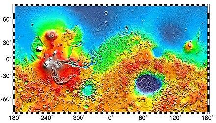
Image:Mars Map.JPG|thumb|upright=2|alt=Map of Mars|<span style="float:center;margin-right:0.5em">[[File:interactive icon.svg|12px|link=|The image above contains clickable links|alt=The image above contains clickable links]]</span><!--{{small|[[Clickable|Clickable image]]}}-->[[Image map|Interactive image map]] of the [[Geography of Mars|global topography of Mars]]. Hover <span class="nomobile">your mouse</span> over the image to see the names of over 60 prominent geographic features, and click to link to them. Coloring of the base map indicates relative [[elevation]]s, based on data from the [[Mars Orbiter Laser Altimeter]] on NASA's ''[[Mars Global Surveyor]]''. Whites and browns indicate the highest elevations ({{val|+12|to|+8|u=km}}); followed by pinks and reds ({{val|+8|to|+3|u=km}}); yellow is {{val|0|u=km}}; greens and blues are lower elevations (down to {{val|-8|u=km}}). [[Cartesian coordinate system|Axes]] are [[latitude]] and [[longitude]]; [[Geographical pole|Polar regions]] are noted. {{align|right|{{small|(See also: ''[[Template:Features and artificial objects on Mars|Mars Rovers map]]'' and ''[[Template:Features and memorials on Mars|Mars Memorial map]]'') ([[Template:Mars map|view]] • [[Template talk:Mars map|discuss]])}}}} |
||
poly 377 357 423 380 407 405 369 389 [[Acheron Fossae]] |
poly 377 357 423 380 407 405 369 389 [[Acheron Fossae]] |
||
poly 1316 75 1305 231 992 408 677 224 651 71 1069 169 [[Acidalia Planitia]] |
poly 1316 75 1305 231 992 408 677 224 651 71 1069 169 [[Acidalia Planitia]] |
||
૧૩:૨૯, ૭ ફેબ્રુઆરી ૨૦૨૪ સુધીનાં પુનરાવર્તન
(See also: Mars Rovers map and Mars Memorial map) (view • discuss)
Usage
This interactive imagemap template was originally designed to be included in the article "Mars". It is not an article!
To use it in an article, use the code {{Mars map}}.
See also
- Official USGS Mars map
- Basic Mars map image
- List of quadrangles on Mars
- List of artificial objects on Mars#Landing site namings and memorials – (Mars Memorials)
- Template:Features and memorials on Mars – (Mars Memorials map)
- Template:Features and artificial objects on Mars – (Mars Rovers map)
- (Template – ImageMap coordinates)
- (Template – transclusions)