
ચિત્ર:Argentina topo blank.jpg

આ પૂર્વાવલોકનનું કદ: ૪૪૫ × ૫૯૯ પિક્સેલ. અન્ય આવર્તનો: ૧૭૮ × ૨૪૦ પિક્સેલ | ૩૫૭ × ૪૮૦ પિક્સેલ | ૫૭૧ × ૭૬૮ પિક્સેલ | ૭૬૧ × ૧,૦૨૪ પિક્સેલ | ૧,૬૦૦ × ૨,૧૫૩ પિક્સેલ.
મૂળભુત ફાઇલ (૧,૬૦૦ × ૨,૧૫૩ પીક્સલ, ફાઇલનું કદ: ૫૬૫ KB, MIME પ્રકાર: image/jpeg)
| વર્ણન |
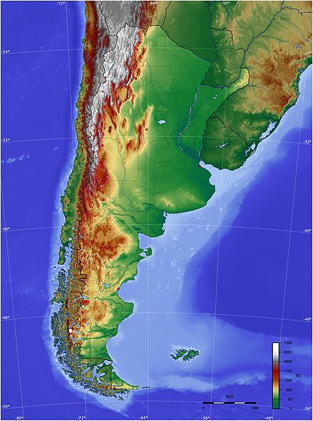
Español: Mapa de Argentina con su relieve
English: Map of Argentina with its terrain levels |
||||||||||
| તારીખ | 9/06/2006 | ||||||||||
| સ્રોત | See below | ||||||||||
| લેખક | Captain Blood | ||||||||||
| પરવાનગી (આ ફાઈલનો ફરી ઉપયોગ) |
|

ફાઇલનો ઇતિહાસ
તારીખ/સમય ઉપર ક્લિક કરવાથી તે સમયે ફાઇલ કેવી હતી તે જોવા મળશે.
| તારીખ/સમય | લઘુચિત્ર | પરિમાણો | સભ્ય | ટિપ્પણી | |
|---|---|---|---|---|---|
| વર્તમાન | ૦૩:૧૫, ૧૪ મે ૨૦૦૯ | | ૧,૬૦૦ × ૨,૧૫૩ (૫૬૫ KB) | Keysanger | reverted. (Deleted yellow line in the Straits of Magellan, added the definitive end of the controversial border at the Beagle Channel and marked with a white box the (last) undefined border zone as agreed both countries.) |
| ૦૯:૪૦, ૫ મે ૨૦૦૯ |  | ૧,૬૦૦ × ૨,૧૫૩ (૮૬૭ KB) | Dexxter | Reverted to version as of 18:57, 9 June 2006 | |
| ૦૧:૪૩, ૫ જૂન ૨૦૦૮ |  | ૧,૬૦૦ × ૨,૧૫૩ (૫૬૫ KB) | Keysanger | Argentina topo deleted yellow line in the Straits of Magellan, added the definitive end of the controversial border at the Beagle Channel and marked with a white box the (last) undefined border zone as agreed both countries. [[Category:[[Category:Topograp | |
| ૦૦:૨૭, ૧૦ જૂન ૨૦૦૬ |  | ૧,૬૦૦ × ૨,૧૫૩ (૮૬૭ KB) | Captain Blood~commonswiki | {{Bild-GFDL-GMT}} |
ફાઇલનો વપરાશ
આ ફાઇલને કોઇ પાનાં વાપરતા નથી.
ફાઇલનો વ્યાપક ઉપયોગ
નીચેની બીજી વિકિઓ આ ફાઈલ વાપરે છે:
- bg.wikipedia.org પર વપરાશ
- bn.wikipedia.org પર વપરાશ
- ca.wikipedia.org પર વપરાશ
- ckb.wikipedia.org પર વપરાશ
- dz.wikipedia.org પર વપરાશ
- ee.wikipedia.org પર વપરાશ
- el.wikipedia.org પર વપરાશ
- en.wikipedia.org પર વપરાશ
- eo.wikipedia.org પર વપરાશ
- es.wikipedia.org પર વપરાશ
- eu.wikipedia.org પર વપરાશ
- fa.wikipedia.org પર વપરાશ
- fi.wikipedia.org પર વપરાશ
- fr.wikipedia.org પર વપરાશ
- gcr.wikipedia.org પર વપરાશ
- hu.wikipedia.org પર વપરાશ
- hy.wikipedia.org પર વપરાશ
- incubator.wikimedia.org પર વપરાશ
- io.wikipedia.org પર વપરાશ
- it.wikipedia.org પર વપરાશ
- ja.wikipedia.org પર વપરાશ
- ka.wikipedia.org પર વપરાશ
- kbd.wikipedia.org પર વપરાશ
- ko.wikipedia.org પર વપરાશ
- ml.wikipedia.org પર વપરાશ
- ms.wikipedia.org પર વપરાશ
- mt.wikipedia.org પર વપરાશ
- pl.wikipedia.org પર વપરાશ
- pt.wikipedia.org પર વપરાશ
આ ફાઇલના વધુ વૈશ્વિક વપરાશ જુઓ.