
ચિત્ર:Koppen-Geiger Map ARG present.svg

Size of this PNG preview of this SVG file: ૫૧૨ × ૪૨૩ પિક્સેલ. અન્ય આવર્તનો: ૨૯૧ × ૨૪૦ પિક્સેલ | ૫૮૧ × ૪૮૦ પિક્સેલ | ૯૩૦ × ૭૬૮ પિક્સેલ | ૧,૨૪૦ × ૧,૦૨૪ પિક્સેલ | ૨,૪૭૯ × ૨,૦૪૮ પિક્સેલ.
મૂળભુત ફાઇલ (SVG ફાઇલ, માત્ર ૫૧૨ × ૪૨૩ પીક્સલ, ફાઇલનું કદ: ૧.૨૧ MB)
સારાંશ:
| વર્ણન |
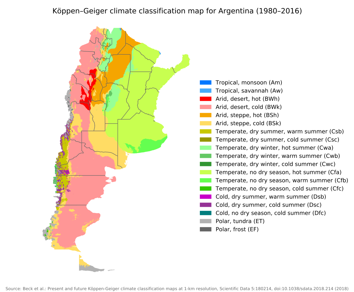
English: Köppen–Geiger climate classification map for Argentina |
| તારીખ | |
| સ્રોત | "Present and future Köppen-Geiger climate classification maps at 1-km resolution". Nature Scientific Data. DOI:10.1038/sdata.2018.214. |
| લેખક | Beck, H.E., Zimmermann, N. E., McVicar, T. R., Vergopolan, N., Berg, A., & Wood, E. F. |
પરવાના
This file is licensed under the Creative Commons Attribution 4.0 International license.
- તમે મુક્ત છો:
- વહેંચવા – નકલ કરવા, વિતરણ કરવા અને રચનાઓ મોકલવા
- રીમિક્સ કરવા કે મઠારવા – રચના અપનાવવા
- નીચેની શરત હેઠળ:
- આરોપણ – તમારે આ રચનાનો ઉપયોગ કરવા માટે લેખક કે પ્રકાશન અધિકાર ધારકની યોગ્ય માહિતી, પરવાનગી (લાયસન્સ)ની કડી અને તેમાં ફેરફાર કર્યો હોય તો તેનો ઉલ્લેખ કરવો જ પડશે. તમે આ સત્તા અનુસાર જ આ રચનાનો પ્રયોગ થવો જોઈએ, પણ તેઓ તમને અથવા તમારા ઉપયોગ સાથે સંમત થાય છે તે રીતે નહીં.
| Camera location | | View this and other nearby images on: OpenStreetMap |
|---|
ફાઇલનો ઇતિહાસ
તારીખ/સમય ઉપર ક્લિક કરવાથી તે સમયે ફાઇલ કેવી હતી તે જોવા મળશે.
| તારીખ/સમય | લઘુચિત્ર | પરિમાણો | સભ્ય | ટિપ્પણી | |
|---|---|---|---|---|---|
| વર્તમાન | ૧૪:૪૪, ૮ સપ્ટેમ્બર ૨૦૨૦ | | ૫૧૨ × ૪૨૩ (૧.૨૧ MB) | Allice Hunter | Provinces and adjustments |
| ૨૧:૧૪, ૧૭ જુલાઇ ૨૦૨૦ |  | ૧,૨૦૮ × ૮૫૦ (૧.૫૧ MB) | JPLema | Reverted to version as of 21:36, 15 June 2020 (UTC) | |
| ૨૧:૧૩, ૧૭ જુલાઇ ૨૦૨૦ |  | ૮૪૦ × ૮૧૨ (૧.૪૫ MB) | JPLema | reducción de tamaño | |
| ૦૩:૦૬, ૧૬ જૂન ૨૦૨૦ |  | ૧,૨૦૮ × ૮૫૦ (૧.૫૧ MB) | JPLema | Reverted to version as of 03:03, 26 November 2018 (UTC) | |
| ૧૮:૩૨, ૧૫ જૂન ૨૦૨૦ |  | ૬૯૬ × ૧,૦૦૬ (૧.૩૪ MB) | JPLema | reduje el ancho y aumenté la altura | |
| ૦૮:૩૩, ૨૬ નવેમ્બર ૨૦૧૮ |  | ૧,૨૦૮ × ૮૫૦ (૧.૫૧ MB) | NVergopolan | {{Information |Description={{en| Köppen–Geiger climate classification map for Argentina}}|date=2018-11-06|source={{cite journal | journal=Nature Scientific Data |doi=10.1038/sdata.2018.214}}|author=Beck, H.E., Zimmermann, N. E., McVicar, T. R., Vergopolan, N., Berg, A., & Wood, E. F.|permission=|other_versions=|other_fields=}}{{Cc-by-4.0}}{{Location|-38.42003918|-63.58480835}}Category:Köppen-Geiger Climate Classification MapsCategory:present climate (1980–2016)Category:Argentina[[... |
ફાઇલનો વપરાશ
આ ફાઇલને કોઇ પાનાં વાપરતા નથી.
ફાઇલનો વ્યાપક ઉપયોગ
નીચેની બીજી વિકિઓ આ ફાઈલ વાપરે છે:
- bg.wikipedia.org પર વપરાશ
- ckb.wikipedia.org પર વપરાશ
- en.wikipedia.org પર વપરાશ
- id.wikipedia.org પર વપરાશ
- ja.wikipedia.org પર વપરાશ
- km.wikipedia.org પર વપરાશ
- pt.wikipedia.org પર વપરાશ
- ru.wikipedia.org પર વપરાશ
- sr.wikipedia.org પર વપરાશ
- tr.wikipedia.org પર વપરાશ
- uk.wikipedia.org પર વપરાશ