
ચિત્ર:Map AP dist all shaded.png
આ પૂર્વાવલોકનનું કદ: ૭૦૨ × ૫૯૯ પિક્સેલ. અન્ય આવર્તનો: ૨૮૧ × ૨૪૦ પિક્સેલ | ૫૬૨ × ૪૮૦ પિક્સેલ | ૯૨૨ × ૭૮૭ પિક્સેલ.
મૂળભુત ફાઇલ (૯૨૨ × ૭૮૭ પીક્સલ, ફાઇલનું કદ: ૧૧૦ KB, MIME પ્રકાર: image/png)

|
This map image could be re-created using vector graphics as an SVG file. This has several advantages; see Commons:Media for cleanup for more information. If an SVG form of this image is available, please upload it and afterwards replace this template with
{{vector version available|new image name}}.
It is recommended to name the SVG file “Map AP dist all shaded.svg”—then the template Vector version available (or Vva) does not need the new image name parameter. |
સારાંશ:
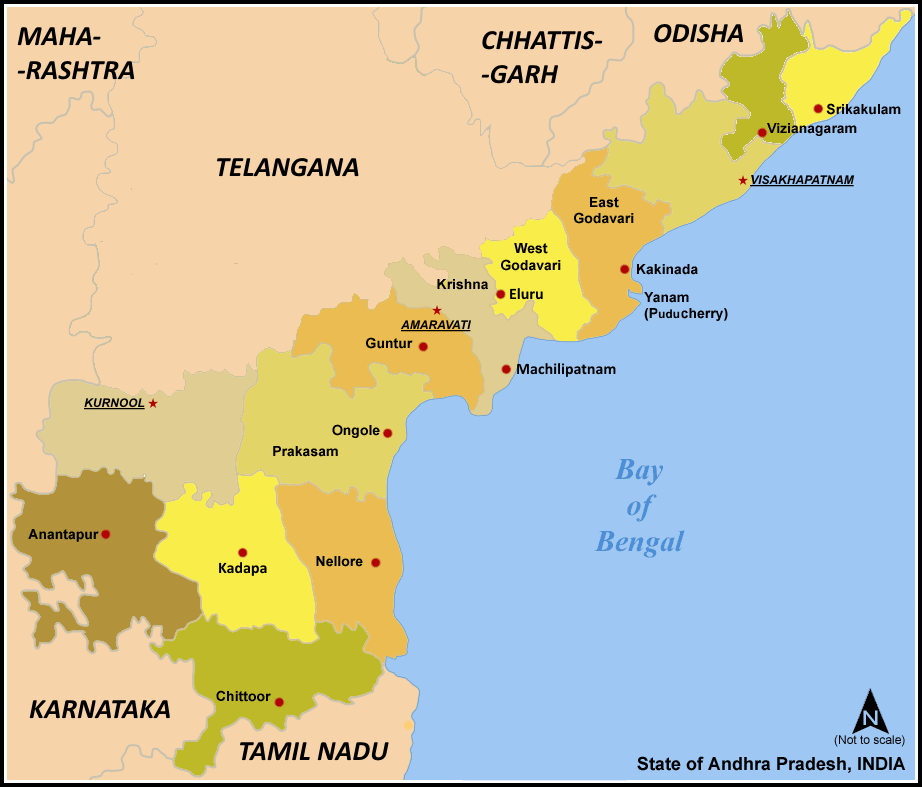
| વર્ણન | Map of w:Andhra Pradesh, India with district boundaries - add districts shaded. |
| તારીખ | ૭ જાન્યુઆરી ૨૦૦૬ (original upload date) |
| સ્રોત | No machine-readable source provided. Own work assumed (based on copyright claims). |
| લેખક | No machine-readable author provided. Miljoshi assumed (based on copyright claims). |
| અન્ય આવૃત્તિઓ | For updated version covering Reorganisation of Andhra Pradesh into Telangana and Andhra Pradesh File:Ap-districts.png |
પરવાના
હું, આ કાર્યનો પ્રકાશનાધિકાર ધારક, તેને નીચેના પરવાનાઓ હેઠળ અહીં પ્રકાશીત કરૂં છું:

|
આ રચનાની નકલ કરવા, વિતરણ અને સુધારો કરવા માટે GNU Free Documentation License, આવૃત્તિ 1.2 કે અન્ય આગળની આવૃત્તિ Free Software Foundation હેઠળ પરવાનગી છે; જેમાં કોઈ Invariant Sections, no Front-Cover Texts, and no Back-Cover Texts નથી. આ પરવાનાની પ્રત GNU Free Documentation License વિભાગમાં છે. |
| આ ફાઈલ વપરાશની પરવાનગી : Creative Commons Attribution-Share Alike 3.0 Unported license. | ||
| ||
| GFDL licensing update ના ભાગ રૂપે આ પરવાનાનો ટેગ ફાઈલ પર લગાડવામાં આવ્યો છે. |
આ ફાઈલ વપરાશની પરવાનગી : Creative Commons Attribution-Share Alike 2.5 Generic, 2.0 Generic and 1.0 Generic license.
- તમે મુક્ત છો:
- વહેંચવા – નકલ કરવા, વિતરણ કરવા અને રચનાઓ મોકલવા
- રીમિક્સ કરવા કે મઠારવા – રચના અપનાવવા
- નીચેની શરત હેઠળ:
- આરોપણ – તમારે આ રચનાનો ઉપયોગ કરવા માટે લેખક કે પ્રકાશન અધિકાર ધારકની યોગ્ય માહિતી, પરવાનગી (લાયસન્સ)ની કડી અને તેમાં ફેરફાર કર્યો હોય તો તેનો ઉલ્લેખ કરવો જ પડશે. તમે આ સત્તા અનુસાર જ આ રચનાનો પ્રયોગ થવો જોઈએ, પણ તેઓ તમને અથવા તમારા ઉપયોગ સાથે સંમત થાય છે તે રીતે નહીં.
- શેર- અલાઈક (બિન ભેદભાવ વહેંચણી) – તમે જો આ રચનાને બદલશો, તેમાં ફેરફાર કરશો અથવા તેના પર આધારિત કોઇ કાર્ય બનાવશો તો તમારે પરિણામી કાર્યને તે જ અથવા અનુરૂપ પરવાનગી હેઠળ જ પ્રકાશિત કરવું પડશે.
તમે તમારી પસંદગીનો પરવાનો પસંદ કરી શકો છો.
ફાઇલનો ઇતિહાસ
તારીખ/સમય ઉપર ક્લિક કરવાથી તે સમયે ફાઇલ કેવી હતી તે જોવા મળશે.
| તારીખ/સમય | લઘુચિત્ર | પરિમાણો | સભ્ય | ટિપ્પણી | |
|---|---|---|---|---|---|
| વર્તમાન | ૧૩:૨૭, ૮ માર્ચ ૨૦૨૧ | | ૯૨૨ × ૭૮૭ (૧૧૦ KB) | Sbb1413 | Added the names of unnamed district HQs, plus the surrounding states. Removed the locator map as it (incorrectly) shows Aksai Chin as under the administration of India. |
| ૧૨:૪૫, ૫ માર્ચ ૨૦૨૧ |  | ૯૨૩ × ૭૯૦ (૧૦૫ KB) | Sbb1413 | Removed Hyderabad as capital, added Amaravati, Kurnool and Visakhapatnam as capitals. | |
| ૧૬:૫૦, ૨ જૂન ૨૦૧૪ |  | ૯૨૩ × ૮૮૧ (૮૩ KB) | Adityamadhav83 | map updated after bifurcation of Andhra Pradesh | |
| ૧૭:૪૯, ૭ જાન્યુઆરી ૨૦૦૬ |  | ૯૨૩ × ૮૮૧ (૬૩ KB) | Miljoshi | Map of w:Andhra Pradesh, India with district boundaries - add districts shaded. Category:Andhra Pradesh district maps |
ફાઇલનો વપરાશ
આ ફાઇલ માં 14 નીચેનાં પાનાઓ વપરાયેલાં છે:
ફાઇલનો વ્યાપક ઉપયોગ
નીચેની બીજી વિકિઓ આ ફાઈલ વાપરે છે:
- ast.wikipedia.org પર વપરાશ
- awa.wikipedia.org પર વપરાશ
- bn.wikipedia.org પર વપરાશ
- ca.wikipedia.org પર વપરાશ
- es.wikipedia.org પર વપરાશ
- fi.wikipedia.org પર વપરાશ
- frr.wikipedia.org પર વપરાશ
- fr.wikipedia.org પર વપરાશ
- hi.wikipedia.org પર વપરાશ
- hu.wikipedia.org પર વપરાશ
- id.wikipedia.org પર વપરાશ
- it.wikipedia.org પર વપરાશ
- ja.wikipedia.org પર વપરાશ
- kn.wikipedia.org પર વપરાશ
- ml.wikipedia.org પર વપરાશ
- nl.wikipedia.org પર વપરાશ
- no.wikipedia.org પર વપરાશ
- pam.wikipedia.org પર વપરાશ
- pl.wikipedia.org પર વપરાશ
આ ફાઇલના વધુ વૈશ્વિક વપરાશ જુઓ.