
ચિત્ર:Administrative map of Gujarat.png

આ પૂર્વાવલોકનનું કદ: ૭૫૬ × ૬૦૦ પિક્સેલ. અન્ય આવર્તનો: ૩૦૩ × ૨૪૦ પિક્સેલ | ૬૦૫ × ૪૮૦ પિક્સેલ | ૯૬૮ × ૭૬૮ પિક્સેલ | ૧,૨૮૦ × ૧,૦૧૫ પિક્સેલ | ૨,૫૬૦ × ૨,૦૩૧ પિક્સેલ | ૩,૦૧૪ × ૨,૩૯૧ પિક્સેલ.
મૂળભુત ફાઇલ (૩,૦૧૪ × ૨,૩૯૧ પીક્સલ, ફાઇલનું કદ: ૬૬૦ KB, MIME પ્રકાર: image/png)
સારાંશ:
| વર્ણન |
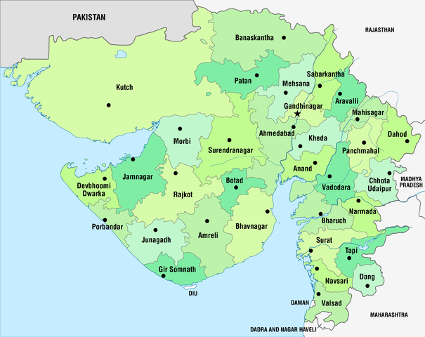
Deutsch: Administrative Karte von Gujarat in der Verwaltungsgliederung seit 15.08.2013
English: Administrative map of Gujarat with the administrative divisions since August 15, 2013 |
||
| તારીખ | see file history | ||
| સ્રોત | પોતાની રચના, using this map | ||
| લેખક | Maximilian Dörrbecker (Chumwa) | ||
| પરવાનગી (આ ફાઈલનો ફરી ઉપયોગ) |
હું, આ કાર્યનો પ્રકાશનાધિકાર ધારક, તેને નીચેના પરવાનાઓ હેઠળ અહીં પ્રકાશીત કરૂં છું:
આ ફાઈલ વપરાશની પરવાનગી : Creative Commons Attribution-Share Alike 3.0 Unported license.
તમે તમારી પસંદગીનો પરવાનો પસંદ કરી શકો છો. |
||
| અન્ય આવૃત્તિઓ |
|


.svg)

|
This locator map image could be re-created using vector graphics as an SVG file. This has several advantages; see Commons:Media for cleanup for more information. If an SVG form of this image is available, please upload it and afterwards replace this template with
{{vector version available|new image name}}.
It is recommended to name the SVG file “Administrative map of Gujarat.svg”—then the template Vector version available (or Vva) does not need the new image name parameter. |

|
This map has been made or improved in the German Kartenwerkstatt (Map Lab). You can propose maps to improve as well.
|
ફાઇલનો ઇતિહાસ
તારીખ/સમય ઉપર ક્લિક કરવાથી તે સમયે ફાઇલ કેવી હતી તે જોવા મળશે.
| તારીખ/સમય | લઘુચિત્ર | પરિમાણો | સભ્ય | ટિપ્પણી | |
|---|---|---|---|---|---|
| વર્તમાન | ૧૦:૩૩, ૧૯ નવેમ્બર ૨૦૧૩ | | ૩,૦૧૪ × ૨,૩૯૧ (૬૬૦ KB) | Chumwa | == {{int:filedesc}} == {{Information |Description= {{de|Administrative Karte von Gujarat in der Verwaltungsgliederung seit 15.08.2013}} {{en|Administrative map of Gujarat with the administrative divisions since August 15... |
ફાઇલનો વપરાશ
આ ફાઇલને કોઇ પાનાં વાપરતા નથી.
ફાઇલનો વ્યાપક ઉપયોગ
નીચેની બીજી વિકિઓ આ ફાઈલ વાપરે છે:
- bg.wikipedia.org પર વપરાશ
- bh.wikipedia.org પર વપરાશ
- टेम्पलेट:गुजरात
- अहमदाबाद जिला
- अमरेली जिला
- आनंद जिला
- बनासकांठा जिला
- भरूच जिला
- भावनगर जिला
- दाहोद जिला
- दांग जिला
- गांधीनगर जिला
- जामनगर जिला
- जूनागढ़ जिला
- खेड़ा जिला
- कच्छ जिला
- महीसागर जिला
- मेहसाणा जिला
- मोरबी जिला
- नर्मदा जिला
- नवसारी जिला
- पंचमहल जिला
- पाटन जिला
- पोरबंदर जिला
- राजकोट जिला
- साबरकांठा जिला
- सूरत जिला
- सुरेंद्रनगर जिला
- तापी जिला
- वड़ोदरा जिला
- वलसाड़ जिला
- अरावली जिला
- बोटाद जिला
- छोटा उदयपुर जिला
- देवभूमि द्वारका जिला
- गिर सोमनाथ जिला
- bn.wikipedia.org પર વપરાશ
- ca.wikipedia.org પર વપરાશ
આ ફાઇલના વધુ વૈશ્વિક વપરાશ જુઓ.