
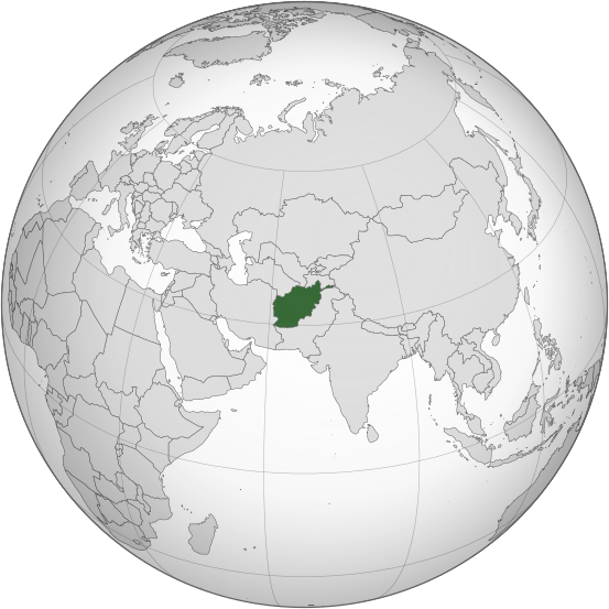
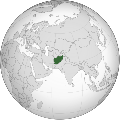
ચિત્ર:Afghanistan (orthographic projection).svg

Size of this PNG preview of this SVG file: ૫૫૩ × ૫૫૩ પિક્સેલ. અન્ય આવર્તનો: ૨૪૦ × ૨૪૦ પિક્સેલ | ૪૮૦ × ૪૮૦ પિક્સેલ | ૭૬૮ × ૭૬૮ પિક્સેલ | ૧,૦૨૪ × ૧,૦૨૪ પિક્સેલ | ૨,૦૪૮ × ૨,૦૪૮ પિક્સેલ.
મૂળભુત ફાઇલ (SVG ફાઇલ, માત્ર ૫૫૩ × ૫૫૩ પીક્સલ, ફાઇલનું કદ: ૨૯૮ KB)
.svg)
સારાંશ:
| વર્ણન |
اردو: طرحی متعامد از افغانستان |
| તારીખ | |
| સ્રોત | Own work based on: India (orthographic projection).svg by Ssolbergj |
| લેખક | Shahid Parvez |
| SVG genesis |
.svg)
પરવાના
The map has been created with the Generic Mapping Tools: https://www.generic-mapping-tools.org/ using one or more of these public-domain datasets for the relief:
|

|
આ રચનાની નકલ કરવા, વિતરણ અને સુધારો કરવા માટે GNU Free Documentation License, આવૃત્તિ 1.2 કે અન્ય આગળની આવૃત્તિ Free Software Foundation હેઠળ પરવાનગી છે; જેમાં કોઈ Invariant Sections, no Front-Cover Texts, and no Back-Cover Texts નથી. આ પરવાનાની પ્રત GNU Free Documentation License વિભાગમાં છે. |
અસલ - મૂળ અપલોડનો લોગ
Transferred from en.wikipedia to Commons by Cirt using CommonsHelper.
The original description page was here. All following user names refer to en.wikipedia.
- 2009-10-05 17:28 Parvez gsm 541×541× (517730 bytes) {{Information |Description = Afghanistan orthographic_projection |Source = I have created this work entirely by myself. |Date = October 5 |Author = Shahid Parvez |other_versions = }}
ફાઇલનો ઇતિહાસ
તારીખ/સમય ઉપર ક્લિક કરવાથી તે સમયે ફાઇલ કેવી હતી તે જોવા મળશે.
| તારીખ/સમય | લઘુચિત્ર | પરિમાણો | સભ્ય | ટિપ્પણી | |
|---|---|---|---|---|---|
| વર્તમાન | ૨૦:૧૬, ૨૭ જુલાઇ ૨૦૧૯ | | ૫૫૩ × ૫૫૩ (૨૯૮ KB) | Cerebellum | Revert to prior version, please provide a source for those territorial claims |
| ૧૫:૫૯, ૨૬ જુલાઇ ૨૦૧૯ |  | ૭૨૦ × ૭૨૦ (૩૮૪ KB) | Lakshmisreekanth | Updated color | |
| ૨૨:૩૦, ૨૫ જુલાઇ ૨૦૧૯ |  | ૭૨૦ × ૭૨૭ (૩૯૭ KB) | Lakshmisreekanth | Added claimed regions | |
| ૦૫:૦૬, ૧૭ માર્ચ ૨૦૧૫ |  | ૫૫૩ × ૫૫૩ (૨૯૮ KB) | Flappiefh | Removed Somaliland and Kosovo. Separated Western Sahara and Morroco. | |
| ૧૮:૧૩, ૪ ઓગસ્ટ ૨૦૧૩ |  | ૫૫૩ × ૫૫૩ (૩૦૨ KB) | Flappiefh | Added South Sudan. The map is now centered on Afghanistan. | |
| ૦૪:૧૫, ૨૧ નવેમ્બર ૨૦૦૯ |  | ૫૪૧ × ૫૪૧ (૫૦૬ KB) | File Upload Bot (Magnus Manske) | {{BotMoveToCommons|en.wikipedia|year={{subst:CURRENTYEAR}}|month={{subst:CURRENTMONTHNAME}}|day={{subst:CURRENTDAY}}}} {{Information |Description={{en|Afghanistan orthographic_projection}} |Source=Transferred from [http://en.wikipedia.org en.wikipedia]; |
ફાઇલનો વપરાશ
આ ફાઇલ માં 2 નીચેનાં પાનાઓ વપરાયેલાં છે:
ફાઇલનો વ્યાપક ઉપયોગ
નીચેની બીજી વિકિઓ આ ફાઈલ વાપરે છે:
- ady.wikipedia.org પર વપરાશ
- af.wikipedia.org પર વપરાશ
- ami.wikipedia.org પર વપરાશ
- arc.wikipedia.org પર વપરાશ
- ar.wikipedia.org પર વપરાશ
- arz.wikipedia.org પર વપરાશ
- ast.wikipedia.org પર વપરાશ
- as.wikipedia.org પર વપરાશ
- av.wikipedia.org પર વપરાશ
- awa.wikipedia.org પર વપરાશ
- azb.wikipedia.org પર વપરાશ
- az.wikipedia.org પર વપરાશ
- az.wiktionary.org પર વપરાશ
- ba.wikipedia.org પર વપરાશ
- bbc.wikipedia.org પર વપરાશ
- be-tarask.wikipedia.org પર વપરાશ
- be.wikipedia.org પર વપરાશ
- bg.wikipedia.org પર વપરાશ
- bh.wikipedia.org પર વપરાશ
- bi.wikipedia.org પર વપરાશ
- bn.wikipedia.org પર વપરાશ
- bn.wikivoyage.org પર વપરાશ
- br.wikipedia.org પર વપરાશ
આ ફાઇલના વધુ વૈશ્વિક વપરાશ જુઓ.
.svg)
.svg)