
ચિત્ર:Baltoro region from space annotated.png

આ પૂર્વાવલોકનનું કદ: ૬૩૩ × ૬૦૦ પિક્સેલ. અન્ય આવર્તનો: ૨૫૩ × ૨૪૦ પિક્સેલ | ૫૦૭ × ૪૮૦ પિક્સેલ | ૮૧૧ × ૭૬૮ પિક્સેલ | ૧,૦૮૧ × ૧,૦૨૪ પિક્સેલ | ૨,૩૩૬ × ૨,૨૧૩ પિક્સેલ.
મૂળભુત ફાઇલ (૨,૩૩૬ × ૨,૨૧૩ પીક્સલ, ફાઇલનું કદ: ૯.૮૪ MB, MIME પ્રકાર: image/png)
| વર્ણન |
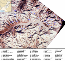
English: Baltoro region from space. Many mountains (e.g. K2, Broad Peak, Gasherbrums, Trango Towers) and glaciers are marked. |
| તારીખ |
(UTC) 2000-02-14 |
| સ્રોત | |
| લેખક |
|
| અન્ય આવૃત્તિઓ | Image:Baltororegion aus dem Weltraum - deutsch.png (deutsche Beschriftung - German Annotations) |
| This is a retouched picture, which means that it has been digitally altered from its original version. Modifications: ISS-image rotated, cropped, marked, pk-map.png included, region marked with a red circle. The original can be viewed here: Karakoram ISS.jpg:
|
| This is a retouched picture, which means that it has been digitally altered from its original version. Modifications: ISS-image rotated, cropped, marked, pk-map.png included, region marked with a red circle. The original can be viewed here: Pk-map.png:
|
આ ફાઈલ વપરાશની પરવાનગી : Creative Commons Attribution-Share Alike 3.0 Unported license.
- તમે મુક્ત છો:
- વહેંચવા – નકલ કરવા, વિતરણ કરવા અને રચનાઓ મોકલવા
- રીમિક્સ કરવા કે મઠારવા – રચના અપનાવવા
- નીચેની શરત હેઠળ:
- આરોપણ – તમારે આ રચનાનો ઉપયોગ કરવા માટે લેખક કે પ્રકાશન અધિકાર ધારકની યોગ્ય માહિતી, પરવાનગી (લાયસન્સ)ની કડી અને તેમાં ફેરફાર કર્યો હોય તો તેનો ઉલ્લેખ કરવો જ પડશે. તમે આ સત્તા અનુસાર જ આ રચનાનો પ્રયોગ થવો જોઈએ, પણ તેઓ તમને અથવા તમારા ઉપયોગ સાથે સંમત થાય છે તે રીતે નહીં.
- શેર- અલાઈક (બિન ભેદભાવ વહેંચણી) – તમે જો આ રચનાને બદલશો, તેમાં ફેરફાર કરશો અથવા તેના પર આધારિત કોઇ કાર્ય બનાવશો તો તમારે પરિણામી કાર્યને તે જ અથવા અનુરૂપ પરવાનગી હેઠળ જ પ્રકાશિત કરવું પડશે.
અસલ - મૂળ અપલોડનો લોગ
This image is a derivative work of the following images:
- Image:Pk-map.png licensed with PD-USGov-CIA-WF
- 2005-03-04T20:56:46Z Alfio 330x354 (14233 Bytes) CIA map of Pakistan
Uploaded with derivativeFX
ફાઇલનો ઇતિહાસ
તારીખ/સમય ઉપર ક્લિક કરવાથી તે સમયે ફાઇલ કેવી હતી તે જોવા મળશે.
| તારીખ/સમય | લઘુચિત્ર | પરિમાણો | સભ્ય | ટિપ્પણી | |
|---|---|---|---|---|---|
| વર્તમાન | ૨૧:૨૬, ૨૧ નવેમ્બર ૨૦૦૮ | | ૨,૩૩૬ × ૨,૨૧૩ (૯.૮૪ MB) | Rupert Pupkin | {{Information |Description={{en|1=Baltoro region from space. Many mountains (e.g. K2, Broad Peak, Gasherbrums, Trango Towers) and glaciers are marked. |Source=*Image:Pk-map.png |Date=2008-11-21 15:50 (UTC) |Author=*derivative work: ~~~ *[[:Image:Pk- |
ફાઇલનો વપરાશ
આ ફાઇલને કોઇ પાનાં વાપરતા નથી.
ફાઇલનો વ્યાપક ઉપયોગ
નીચેની બીજી વિકિઓ આ ફાઈલ વાપરે છે:
- arz.wikipedia.org પર વપરાશ
- az.wikipedia.org પર વપરાશ
- bn.wikipedia.org પર વપરાશ
- ca.wikipedia.org પર વપરાશ
- da.wikipedia.org પર વપરાશ
- de.wikipedia.org પર વપરાશ
- en.wikipedia.org પર વપરાશ
- es.wikipedia.org પર વપરાશ
- eu.wikipedia.org પર વપરાશ
- fa.wikipedia.org પર વપરાશ
- fr.wikipedia.org પર વપરાશ
- gl.wikipedia.org પર વપરાશ
- hi.wikipedia.org પર વપરાશ
- hu.wikipedia.org પર વપરાશ
- incubator.wikimedia.org પર વપરાશ
- it.wikipedia.org પર વપરાશ
- ja.wikipedia.org પર વપરાશ
- ko.wikipedia.org પર વપરાશ
- lld.wikipedia.org પર વપરાશ
- mai.wikipedia.org પર વપરાશ
આ ફાઇલના વધુ વૈશ્વિક વપરાશ જુઓ.