
ચિત્ર:Bhutan CIA WFB 2010 map.png
આથી વધુ ઘનત્વ ઉપલબ્ધ નથી.
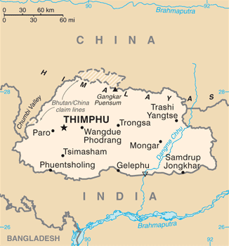
Bhutan_CIA_WFB_2010_map.png (૩૨૬ × ૩૫૦ પીક્સલ, ફાઇલનું કદ: ૧૬ KB, MIME પ્રકાર: image/png)

|
This map image could be re-created using vector graphics as an SVG file. This has several advantages; see Commons:Media for cleanup for more information. If an SVG form of this image is available, please upload it and afterwards replace this template with
{{vector version available|new image name}}.
It is recommended to name the SVG file “Bhutan CIA WFB 2010 map.svg”—then the template Vector version available (or Vva) does not need the new image name parameter. |
સારાંશ:
| વર્ણન | Bhutan map from CIA World Factbook (since June 24, 2010) |
| તારીખ | |
| સ્રોત |
CIA World Factbook, converted from original GIF format |
| લેખક | United States Central Intelligence Agency |
| અન્ય આવૃત્તિઓ |
|
પરવાના
This image is in the public domain because it contains materials that originally came from the United States Central Intelligence Agency's World Factbook.
|
 |
ફાઇલનો ઇતિહાસ
તારીખ/સમય ઉપર ક્લિક કરવાથી તે સમયે ફાઇલ કેવી હતી તે જોવા મળશે.
| તારીખ/સમય | લઘુચિત્ર | પરિમાણો | સભ્ય | ટિપ્પણી | |
|---|---|---|---|---|---|
| વર્તમાન | ૦૧:૧૦, ૭ જુલાઇ ૨૦૧૭ | | ૩૨૬ × ૩૫૦ (૧૬ KB) | Ras67 | cropped, opt. |
| ૧૭:૨૬, ૧૨ મે ૨૦૧૫ |  | ૩૩૦ × ૩૫૪ (૫૨ KB) | Evolt | Updated to version as of April 24, 2015 | |
| ૧૭:૪૭, ૨૨ ઓગસ્ટ ૨૦૧૧ |  | ૩૩૦ × ૩૫૪ (૧૮ KB) | Zyxw | =={{int:filedesc}}== {{Information | Description = Bhutan map from CIA World Factbook ([http://web.archive.org/web/20100704230847/https://www.cia.gov/library/publications/the-world-factbook/geos/bt.html since June 24, 2010]) | Source = CIA World Factbook, |
ફાઇલનો વપરાશ
આ ફાઇલ માં નીચેનું પાનું વપરાયેલું છે:
ફાઇલનો વ્યાપક ઉપયોગ
નીચેની બીજી વિકિઓ આ ફાઈલ વાપરે છે:
- ace.wikipedia.org પર વપરાશ
- af.wikipedia.org પર વપરાશ
- als.wikipedia.org પર વપરાશ
- ar.wikipedia.org પર વપરાશ
- as.wikipedia.org પર વપરાશ
- bcl.wikipedia.org પર વપરાશ
- bh.wikipedia.org પર વપરાશ
- bjn.wikipedia.org પર વપરાશ
- bn.wikipedia.org પર વપરાશ
- ca.wikipedia.org પર વપરાશ
- cy.wikipedia.org પર વપરાશ
- da.wikipedia.org પર વપરાશ
- de.wikipedia.org પર વપરાશ
- de.wiktionary.org પર વપરાશ
- dv.wikipedia.org પર વપરાશ
- dz.wikipedia.org પર વપરાશ
- en.wikipedia.org પર વપરાશ
- en.wiktionary.org પર વપરાશ
- eo.wikipedia.org પર વપરાશ
- es.wikipedia.org પર વપરાશ
- eu.wikipedia.org પર વપરાશ
- fa.wikipedia.org પર વપરાશ
- fi.wikipedia.org પર વપરાશ
આ ફાઇલના વધુ વૈશ્વિક વપરાશ જુઓ.