
ચિત્ર:CEM-36-Regno-di-Nivche-2429.jpg

આ પૂર્વાવલોકનનું કદ: ૮૦૦ × ૫૯૩ પિક્સેલ. અન્ય આવર્તનો: ૩૨૦ × ૨૩૭ પિક્સેલ | ૬૪૦ × ૪૭૪ પિક્સેલ | ૧,૦૨૪ × ૭૫૯ પિક્સેલ | ૧,૨૮૦ × ૯૪૯ પિક્સેલ | ૧,૬૦૦ × ૧,૧૮૬ પિક્સેલ.
મૂળભુત ફાઇલ (૧,૬૦૦ × ૧,૧૮૬ પીક્સલ, ફાઇલનું કદ: ૧.૦૭ MB, MIME પ્રકાર: image/jpeg)
સારાંશ:
| વર્ણન |
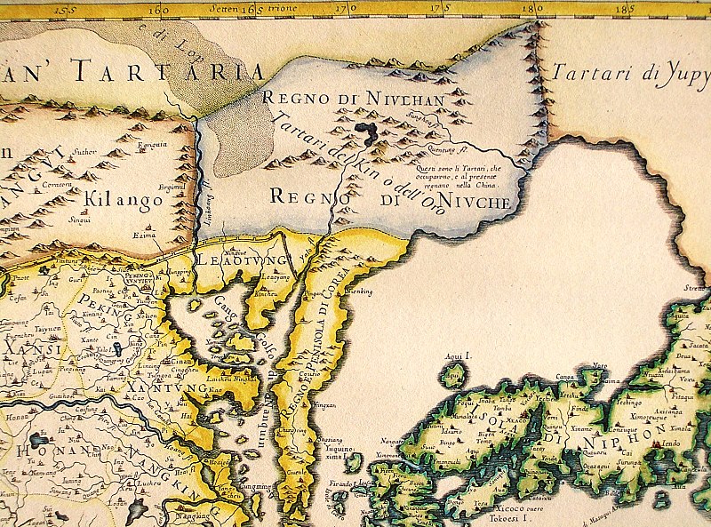
English: Northeastern fragment of a map of China (in Italian), showing the "Tartari del Kin o dell'Oro" (i.e., the Jin Tartars, or the Golden Tartars) populating the "Regno del Niulhan" (?) a.k.a. "Regno del Niuche" (i.e. the Kingdom of the Nüzhen, a.k.a Jurchen") who are further described as "The Tartars who have occupied, and at present are ruling, China". Further northeast, the "Tartari de Yupy" (i.e., "Fishskin Tartars" - the generic name of the Tungusic people of the Amur) are shown.
Italiano: "Il regno della China detto presentemente Catay e Mangin diuiso sopra le carte piu esatte nelle sue principali prouincie" |
| તારીખ | Originally published 1682; the copy at HKUST is a 1689 reprint. |
| સ્રોત |
English: An antique map from the Special Collection "China in Maps" of the Hong Kong University of Science and Technology Library, reproduced by the HKUST Library in the book "China in European Maps", Hong Kong, 2003. ISBN 962-86403-9-9.
Русский: Старинная карта из специальной коллекции Библиотеки Гонконгского научно-технического университета. Опубликована этой библиотекой в книге "China in European Maps" (Китай на европейских картах), Гонконг, 2003. ISBN 962-86403-9-9, тиражом 1000 экз. См. также каталог выставки, Special Collection "China in Maps".
. Fragment of Plate 36: "Il regno della China detto presentemente Catay e Mangin diuiso sopra le carte piu esatte nelle sue principali prouincie" |
| લેખક | Giacomo Cantelli (1643-1695), Giovanni Giacomo de Rossi (1627-1691) |
| અન્ય આવૃત્તિઓ |
Entire map:  |
પરવાના
|
This is a faithful photographic reproduction of a two-dimensional, public domain work of art. The work of art itself is in the public domain for the following reason:
The official position taken by the Wikimedia Foundation is that "faithful reproductions of two-dimensional public domain works of art are public domain".
This photographic reproduction is therefore also considered to be in the public domain in the United States. In other jurisdictions, re-use of this content may be restricted; see Reuse of PD-Art photographs for details. | ||||
ફાઇલનો ઇતિહાસ
તારીખ/સમય ઉપર ક્લિક કરવાથી તે સમયે ફાઇલ કેવી હતી તે જોવા મળશે.
| તારીખ/સમય | લઘુચિત્ર | પરિમાણો | સભ્ય | ટિપ્પણી | |
|---|---|---|---|---|---|
| વર્તમાન | ૧૮:૧૦, ૧૨ ઓગસ્ટ ૨૦૧૩ | | ૧,૬૦૦ × ૧,૧૮૬ (૧.૦૭ MB) | Soerfm | Crop, brightness |
| ૦૯:૩૬, ૧૮ માર્ચ ૨૦૦૯ |  | ૧,૬૦૦ × ૧,૨૦૦ (૧,૦૨૪ KB) | Vmenkov | {{Information |Description={{en|1=Northeastern fragment of a 1682 map of China (in Italian), showing the "Tartari del Kin o dell'Oro" (i.e., the Jin Tartars, or the Golden Tartars) populating the "Regno del Niulhan" (?) a.k.a. "Regno del Niuche" (i.e. the |
ફાઇલનો વપરાશ
આ ફાઇલ માં નીચેનું પાનું વપરાયેલું છે:
ફાઇલનો વ્યાપક ઉપયોગ
નીચેની બીજી વિકિઓ આ ફાઈલ વાપરે છે:
- bcl.wikipedia.org પર વપરાશ
- bg.wikipedia.org પર વપરાશ
- en.wikipedia.org પર વપરાશ
- es.wikipedia.org પર વપરાશ
- fr.wikipedia.org પર વપરાશ
- gl.wikipedia.org પર વપરાશ
- hy.wikipedia.org પર વપરાશ
- id.wikipedia.org પર વપરાશ
- la.wikipedia.org પર વપરાશ
- nl.wikipedia.org પર વપરાશ
- oc.wikipedia.org પર વપરાશ
- pa.wikipedia.org પર વપરાશ
- pnb.wikipedia.org પર વપરાશ
- pt.wikipedia.org પર વપરાશ
- ro.wikipedia.org પર વપરાશ
- ru.wikipedia.org પર વપરાશ
- uk.wikipedia.org પર વપરાશ
- vi.wikipedia.org પર વપરાશ
- war.wikipedia.org પર વપરાશ
- zh.wikipedia.org પર વપરાશ