
ચિત્ર:Dromaius novaehollandiae map distribution 2.svg

Size of this PNG preview of this SVG file: ૭૩૬ × ૬૦૦ પિક્સેલ. અન્ય આવર્તનો: ૨૯૫ × ૨૪૦ પિક્સેલ | ૫૮૯ × ૪૮૦ પિક્સેલ | ૯૪૨ × ૭૬૮ પિક્સેલ | ૧,૨૫૭ × ૧,૦૨૪ પિક્સેલ | ૨,૫૧૩ × ૨,૦૪૮ પિક્સેલ | ૧,૧૦૮ × ૯૦૩ પિક્સેલ.
મૂળભુત ફાઇલ (SVG ફાઇલ, માત્ર ૧,૧૦૮ × ૯૦૩ પીક્સલ, ફાઇલનું કદ: ૧૧૪ KB)
સારાંશ:
| વર્ણન |
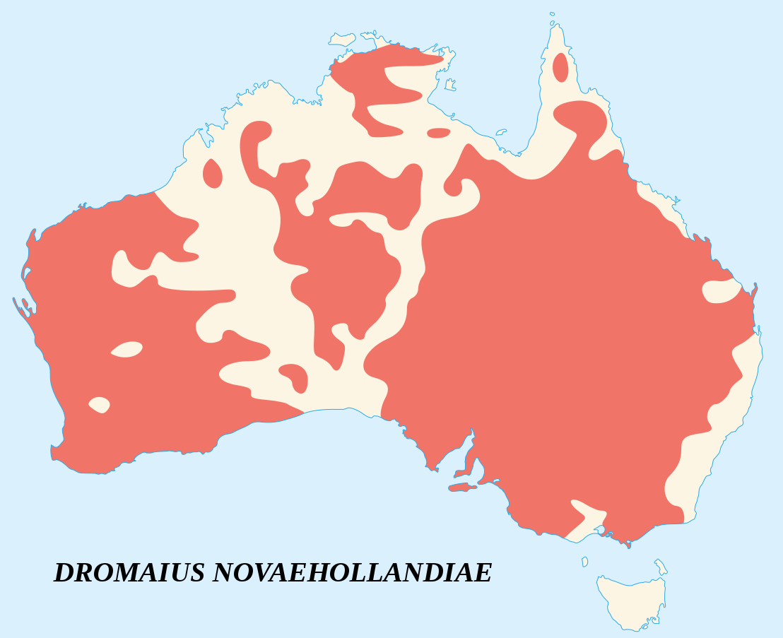
English: Emu's recorded observations map (Dromaius Novaehollandiae).
Areas where emu has been recorded. Français : Carte d'observations de l'Émeu d'Australie (Dromaius Novaehollandiae).
Zones où des émeus ont été observés. |
||
| તારીખ | |||
| સ્રોત |
English:
Français : |
||
| લેખક | Sémhur (talk) | ||
| આરોપણ (required by the license) | © Sémhur / Wikimedia Commons / | ||
| SVG | W3C-validity not checked.
|
||
| Atelier graphique |

| Camera location | | View this and other nearby images on: OpenStreetMap |
|---|
પરવાના
હું, આ કાર્યનો પ્રકાશનાધિકાર ધારક, તેને નીચેના પરવાનાઓ હેઠળ અહીં પ્રકાશીત કરૂં છું:
| Copyleft: કળાની આ રચના મુક્ત/મફત છે; તમે Free Art License ના નિયમોને આધિન આનું વિતરણ કે સુધારો કરી શકો છો. આ લાઈસેંસની પ્રત તમેને Copyleft Attitude site પર કે અન્ય સાઈટ પર મળી શકશે. |
This file is licensed under the Creative Commons Attribution-Share Alike 4.0 International, 3.0 Unported, 2.5 Generic, 2.0 Generic and 1.0 Generic license.
- તમે મુક્ત છો:
- વહેંચવા – નકલ કરવા, વિતરણ કરવા અને રચનાઓ મોકલવા
- રીમિક્સ કરવા કે મઠારવા – રચના અપનાવવા
- નીચેની શરત હેઠળ:
- આરોપણ – તમારે આ રચનાનો ઉપયોગ કરવા માટે લેખક કે પ્રકાશન અધિકાર ધારકની યોગ્ય માહિતી, પરવાનગી (લાયસન્સ)ની કડી અને તેમાં ફેરફાર કર્યો હોય તો તેનો ઉલ્લેખ કરવો જ પડશે. તમે આ સત્તા અનુસાર જ આ રચનાનો પ્રયોગ થવો જોઈએ, પણ તેઓ તમને અથવા તમારા ઉપયોગ સાથે સંમત થાય છે તે રીતે નહીં.
- શેર- અલાઈક (બિન ભેદભાવ વહેંચણી) – તમે જો આ રચનાને બદલશો, તેમાં ફેરફાર કરશો અથવા તેના પર આધારિત કોઇ કાર્ય બનાવશો તો તમારે પરિણામી કાર્યને તે જ અથવા અનુરૂપ પરવાનગી હેઠળ જ પ્રકાશિત કરવું પડશે.
તમે તમારી પસંદગીનો પરવાનો પસંદ કરી શકો છો.
ફાઇલનો ઇતિહાસ
તારીખ/સમય ઉપર ક્લિક કરવાથી તે સમયે ફાઇલ કેવી હતી તે જોવા મળશે.
| તારીખ/સમય | લઘુચિત્ર | પરિમાણો | સભ્ય | ટિપ્પણી | |
|---|---|---|---|---|---|
| વર્તમાન | ૨૦:૩૯, ૨૫ જૂન ૨૦૦૭ | | ૧,૧૦૮ × ૯૦૩ (૧૧૪ KB) | Sémhur | better coast lines |
| ૧૬:૫૯, ૨૪ જૂન ૨૦૦૭ |  | ૧,૧૦૮ × ૯૦૩ (૭૨ KB) | Sémhur | {{Information |Description= {{fr|Carte d'observations de l'émeu (''Dromaius Novaehollandiae'').<br/>Légende : en marron, zones où des émeus ont été observés.}} {{en|Emu's recorded observations map (''Dromaius Novaehollandiae'').<br/>Legend : maroon |
ફાઇલનો વપરાશ
આ ફાઇલ માં નીચેનું પાનું વપરાયેલું છે:
ફાઇલનો વ્યાપક ઉપયોગ
નીચેની બીજી વિકિઓ આ ફાઈલ વાપરે છે:
- an.wikipedia.org પર વપરાશ
- ar.wikipedia.org પર વપરાશ
- arz.wikipedia.org પર વપરાશ
- ast.wikipedia.org પર વપરાશ
- be.wikipedia.org પર વપરાશ
- bg.wikipedia.org પર વપરાશ
- bn.wikipedia.org પર વપરાશ
- ca.wikipedia.org પર વપરાશ
- ceb.wikipedia.org પર વપરાશ
- cs.wikipedia.org પર વપરાશ
- cy.wikipedia.org પર વપરાશ
- de.wikipedia.org પર વપરાશ
- en.wikipedia.org પર વપરાશ
- eo.wikipedia.org પર વપરાશ
- et.wikipedia.org પર વપરાશ
- eu.wikipedia.org પર વપરાશ
- fa.wikipedia.org પર વપરાશ
- fi.wikipedia.org પર વપરાશ
- ga.wikipedia.org પર વપરાશ
- gl.wikipedia.org પર વપરાશ
- he.wikipedia.org પર વપરાશ
- hr.wikipedia.org પર વપરાશ
- hu.wikipedia.org પર વપરાશ
- hy.wikipedia.org પર વપરાશ
- id.wikipedia.org પર વપરાશ
- incubator.wikimedia.org પર વપરાશ
- is.wikipedia.org પર વપરાશ
- ja.wikipedia.org પર વપરાશ
- jv.wikipedia.org પર વપરાશ
- ka.wikipedia.org પર વપરાશ
- kk.wikipedia.org પર વપરાશ
- kn.wikipedia.org પર વપરાશ
- ko.wikipedia.org પર વપરાશ
- kw.wikipedia.org પર વપરાશ
- la.wikipedia.org પર વપરાશ
- lt.wikipedia.org પર વપરાશ
- lv.wikipedia.org પર વપરાશ
- mk.wikipedia.org પર વપરાશ
- ml.wikipedia.org પર વપરાશ
- ms.wikipedia.org પર વપરાશ
- my.wikipedia.org પર વપરાશ
- nn.wikipedia.org પર વપરાશ
- no.wikipedia.org પર વપરાશ
- nv.wikipedia.org પર વપરાશ
- or.wikipedia.org પર વપરાશ
- pa.wikipedia.org પર વપરાશ
આ ફાઇલના વધુ વૈશ્વિક વપરાશ જુઓ.