
ચિત્ર:FraMauroDetailedMapInverted.jpg
આ પૂર્વાવલોકનનું કદ: ૬૦૨ × ૫૯૯ પિક્સેલ. અન્ય આવર્તનો: ૨૪૧ × ૨૪૦ પિક્સેલ | ૪૮૨ × ૪૮૦ પિક્સેલ | ૭૭૧ × ૭૬૮ પિક્સેલ | ૧,૦૨૯ × ૧,૦૨૪ પિક્સેલ | ૨,૨૫૫ × ૨,૨૪૫ પિક્સેલ.
મૂળભુત ફાઇલ (૨,૨૫૫ × ૨,૨૪૫ પીક્સલ, ફાઇલનું કદ: ૬.૪૮ MB, MIME પ્રકાર: image/jpeg)
સારાંશ:
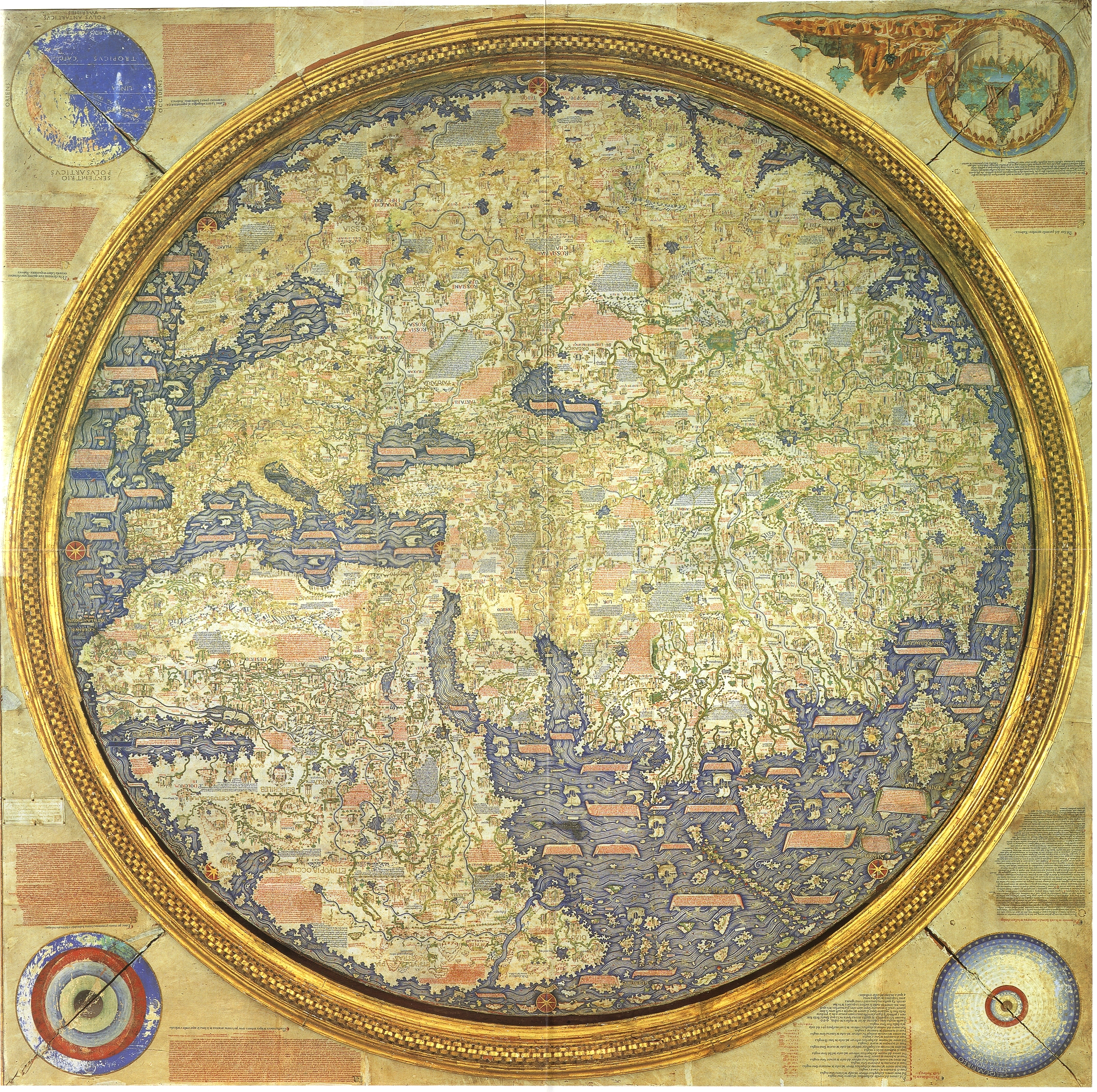
Inverted map of Fra Mauro (1460). Source "The Fra Mauro World map" Piero Falchetta.
પરવાના
|
This is a faithful photographic reproduction of a two-dimensional, public domain work of art. The work of art itself is in the public domain for the following reason:
The official position taken by the Wikimedia Foundation is that "faithful reproductions of two-dimensional public domain works of art are public domain".
This photographic reproduction is therefore also considered to be in the public domain in the United States. In other jurisdictions, re-use of this content may be restricted; see Reuse of PD-Art photographs for details. | ||||
ફાઇલનો ઇતિહાસ
તારીખ/સમય ઉપર ક્લિક કરવાથી તે સમયે ફાઇલ કેવી હતી તે જોવા મળશે.
| તારીખ/સમય | લઘુચિત્ર | પરિમાણો | સભ્ય | ટિપ્પણી | |
|---|---|---|---|---|---|
| વર્તમાન | ૧૫:૪૫, ૧૦ સપ્ટેમ્બર ૨૦૧૬ | | ૨,૨૫૫ × ૨,૨૪૫ (૬.૪૮ MB) | Countakeshi | This image is suppose to be North-South as opposed to the original File:FraMauroDetailedMap.jpg which is South-North |
| ૦૫:૪૬, ૧૪ જુલાઇ ૨૦૧૬ |  | ૨,૨૪૦ × ૨,૨૪૦ (૬.૪૫ MB) | Llann Wé² | Original map with inverted poles | |
| ૦૫:૪૯, ૧૨ જુલાઇ ૨૦૧૬ |  | ૨,૨૫૫ × ૨,૨૪૫ (૬.૪૮ MB) | Cckerberos | Reverted to version as of 12:18, 1 May 2007 (UTC) | |
| ૨૨:૩૧, ૨૩ માર્ચ ૨૦૧૬ |  | ૨,૨૪૦ × ૨,૨૪૦ (૬.૪૫ MB) | SteinsplitterBot | Bot: Image rotated by 180° | |
| ૧૭:૪૮, ૧ મે ૨૦૦૭ |  | ૨,૨૫૫ × ૨,૨૪૫ (૬.૪૮ MB) | World Imaging | Better definition. | |
| ૧૭:૩૫, ૧ મે ૨૦૦૭ |  | ૫૬૪ × ૫૬૧ (૩૭૫ KB) | World Imaging | Inverted map of Fra Mauro (1460). Source "The Fra Mauro World map" Piero Falchetta. |
ફાઇલનો વપરાશ
આ ફાઇલ માં નીચેનું પાનું વપરાયેલું છે:
ફાઇલનો વ્યાપક ઉપયોગ
નીચેની બીજી વિકિઓ આ ફાઈલ વાપરે છે:
- af.wikipedia.org પર વપરાશ
- azb.wikipedia.org પર વપરાશ
- be.wikipedia.org પર વપરાશ
- bn.wikipedia.org પર વપરાશ
- ca.wikipedia.org પર વપરાશ
- cs.wikipedia.org પર વપરાશ
- cv.wikipedia.org પર વપરાશ
- de.wikipedia.org પર વપરાશ
- de.wikibooks.org પર વપરાશ
- en.wikipedia.org પર વપરાશ
- eo.wikipedia.org પર વપરાશ
- es.wikipedia.org પર વપરાશ
- et.wikipedia.org પર વપરાશ
- fa.wikipedia.org પર વપરાશ
- fa.wikibooks.org પર વપરાશ
- fr.wikipedia.org પર વપરાશ
- he.wikipedia.org પર વપરાશ
આ ફાઇલના વધુ વૈશ્વિક વપરાશ જુઓ.