
ચિત્ર:India Geographic Map.jpg

આ પૂર્વાવલોકનનું કદ: ૬૨૨ × ૬૦૦ પિક્સેલ. અન્ય આવર્તનો: ૨૪૯ × ૨૪૦ પિક્સેલ | ૪૯૮ × ૪૮૦ પિક્સેલ | ૭૯૭ × ૭૬૮ પિક્સેલ | ૧,૦૬૨ × ૧,૦૨૪ પિક્સેલ | ૧,૪૪૦ × ૧,૩૮૮ પિક્સેલ.
મૂળભુત ફાઇલ (૧,૪૪૦ × ૧,૩૮૮ પીક્સલ, ફાઇલનું કદ: ૮૦૯ KB, MIME પ્રકાર: image/jpeg)
| વર્ણન |
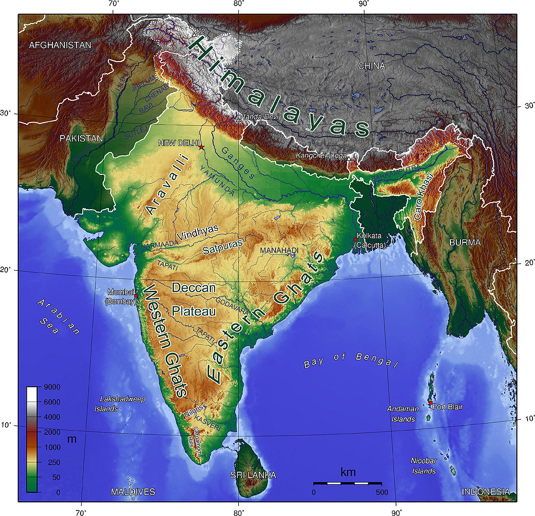
English: Map showing Mountains and Rivers of India |
| સ્રોત | http://en.wikipedia.org/wiki/Image:India_Geographic_Map.jpg |
| લેખક | mukesh Suthar palari |
| અન્ય આવૃત્તિઓ | hindi |

|
આ રચનાની નકલ કરવા, વિતરણ અને સુધારો કરવા માટે GNU Free Documentation License, આવૃત્તિ 1.2 કે અન્ય આગળની આવૃત્તિ Free Software Foundation હેઠળ પરવાનગી છે; જેમાં કોઈ Invariant Sections, no Front-Cover Texts, and no Back-Cover Texts નથી. આ પરવાનાની પ્રત GNU Free Documentation License વિભાગમાં છે. |
| આ ફાઈલ વપરાશની પરવાનગી : Creative Commons Attribution-Share Alike 3.0 Unported license. | ||
| ||
| GFDL licensing update ના ભાગ રૂપે આ પરવાનાનો ટેગ ફાઈલ પર લગાડવામાં આવ્યો છે. |
ફાઇલનો ઇતિહાસ
તારીખ/સમય ઉપર ક્લિક કરવાથી તે સમયે ફાઇલ કેવી હતી તે જોવા મળશે.
| તારીખ/સમય | લઘુચિત્ર | પરિમાણો | સભ્ય | ટિપ્પણી | |
|---|---|---|---|---|---|
| વર્તમાન | ૦૫:૩૩, ૧૭ ઓક્ટોબર ૨૦૦૮ | | ૧,૪૪૦ × ૧,૩૮૮ (૮૦૯ KB) | Carlos-PCC | {{Information |Description=Map showing Mountains and Rivers of India |Source=http://en.wikipedia.org/wiki/Image:India_Geographic_Map.jpg |Date= |Author=Sagredo |Permission={{GFDL}} |other_versions= }} Category:Maps of India <!--{{ImageUpload|basic}}- |
ફાઇલનો વપરાશ
આ ફાઇલ માં 2 નીચેનાં પાનાઓ વપરાયેલાં છે:
ફાઇલનો વ્યાપક ઉપયોગ
નીચેની બીજી વિકિઓ આ ફાઈલ વાપરે છે:
- af.wikipedia.org પર વપરાશ
- ar.wikipedia.org પર વપરાશ
- ast.wikipedia.org પર વપરાશ
- bh.wikipedia.org પર વપરાશ
- bn.wikipedia.org પર વપરાશ
- ca.wikipedia.org પર વપરાશ
- cs.wikipedia.org પર વપરાશ
- cs.wikiquote.org પર વપરાશ
- da.wikipedia.org પર વપરાશ
- de.wikipedia.org પર વપરાશ
- en.wikipedia.org પર વપરાશ
- es.wikipedia.org પર વપરાશ
- fa.wikipedia.org પર વપરાશ
- fi.wikipedia.org પર વપરાશ
- fr.wikipedia.org પર વપરાશ
- hif.wikipedia.org પર વપરાશ
- hi.wikipedia.org પર વપરાશ
- hi.wikibooks.org પર વપરાશ
- hu.wikipedia.org પર વપરાશ
- io.wikipedia.org પર વપરાશ
- it.wikibooks.org પર વપરાશ
- ja.wikipedia.org પર વપરાશ
- lv.wikipedia.org પર વપરાશ
- mai.wikipedia.org પર વપરાશ
- ml.wikipedia.org પર વપરાશ
- mr.wikipedia.org પર વપરાશ
આ ફાઇલના વધુ વૈશ્વિક વપરાશ જુઓ.