
ચિત્ર:Indus river.svg

Size of this PNG preview of this SVG file: ૫૫૫ × ૬૦૦ પિક્સેલ. અન્ય આવર્તનો: ૨૨૨ × ૨૪૦ પિક્સેલ | ૪૪૪ × ૪૮૦ પિક્સેલ | ૭૧૧ × ૭૬૮ પિક્સેલ | ૯૪૮ × ૧,૦૨૪ પિક્સેલ | ૧,૮૯૫ × ૨,૦૪૮ પિક્સેલ | ૨,૩૦૯ × ૨,૪૯૫ પિક્સેલ.
મૂળભુત ફાઇલ (SVG ફાઇલ, માત્ર ૨,૩૦૯ × ૨,૪૯૫ પીક્સલ, ફાઇલનું કદ: ૧૭૨ KB)
https://iasbaba.com/wp-content/uploads/2023/01/Indus-Waters-Treaty.png.webp
સારાંશ:
| વર્ણન |
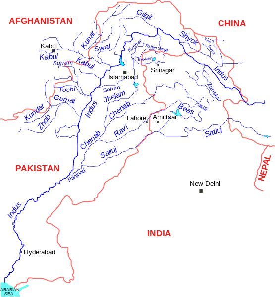
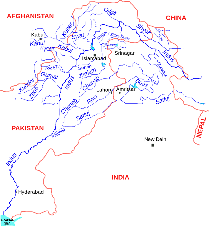
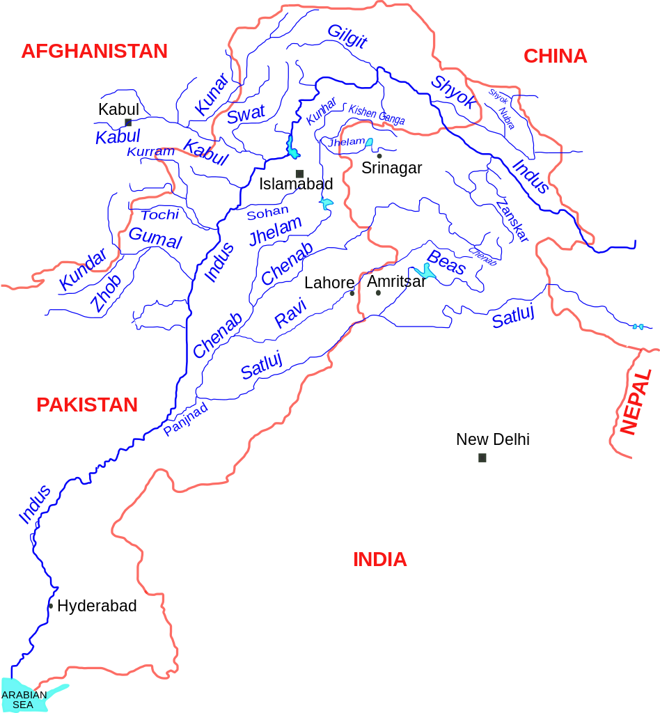
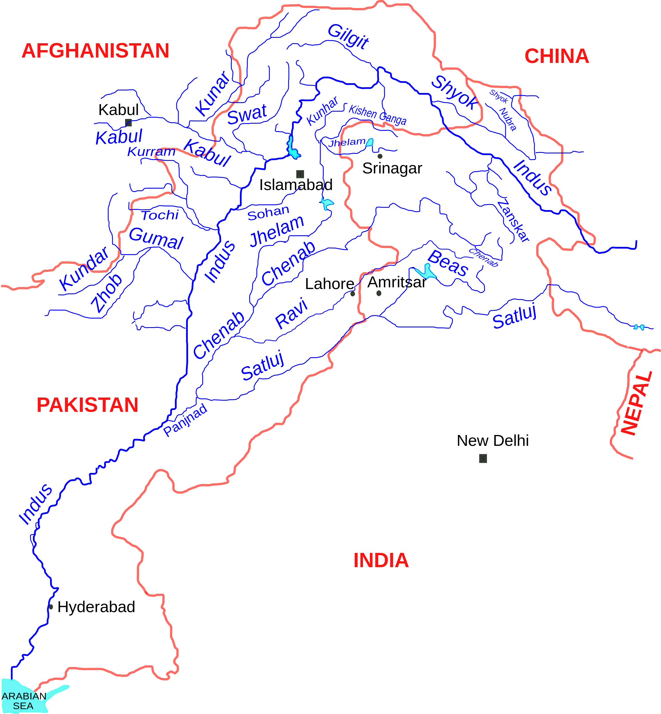
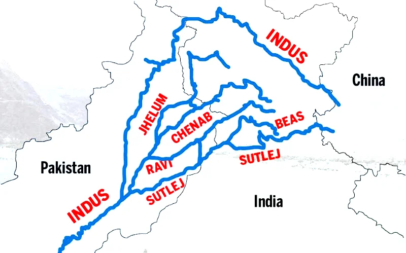
English: Indus river and tributaries, data based on The Times Atlas of the world (Family edition) |
| તારીખ | |
| સ્રોત | પોતાની રચના |
| લેખક | Kmhkmh |
પરવાના
હું, આ કાર્યનો પ્રકાશનાધિકાર ધારક, તેને નીચેના પરવાના હેઠળ અહીં પ્રકાશીત કરૂં છું:
આ ફાઈલ વપરાશની પરવાનગી :Creative Commons Attribution 3.0 Unported license.
- તમે મુક્ત છો:
- વહેંચવા – નકલ કરવા, વિતરણ કરવા અને રચનાઓ મોકલવા
- રીમિક્સ કરવા કે મઠારવા – રચના અપનાવવા
- નીચેની શરત હેઠળ:
- આરોપણ – તમારે આ રચનાનો ઉપયોગ કરવા માટે લેખક કે પ્રકાશન અધિકાર ધારકની યોગ્ય માહિતી, પરવાનગી (લાયસન્સ)ની કડી અને તેમાં ફેરફાર કર્યો હોય તો તેનો ઉલ્લેખ કરવો જ પડશે. તમે આ સત્તા અનુસાર જ આ રચનાનો પ્રયોગ થવો જોઈએ, પણ તેઓ તમને અથવા તમારા ઉપયોગ સાથે સંમત થાય છે તે રીતે નહીં.
| Warning! According to Indian law, it is illegal to produce maps that in the view of the Indian government, misrepresent Indian territories by showing areas the Indian government claims ownership of but does not control as not belonging to India or as being contested. |
ફાઇલનો ઇતિહાસ
તારીખ/સમય ઉપર ક્લિક કરવાથી તે સમયે ફાઇલ કેવી હતી તે જોવા મળશે.
| તારીખ/સમય | લઘુચિત્ર | પરિમાણો | સભ્ય | ટિપ્પણી | |
|---|---|---|---|---|---|
| વર્તમાન | ૧૬:૪૯, ૧૧ સપ્ટેમ્બર ૨૦૧૭ | | ૨,૩૦૯ × ૨,૪૯૫ (૧૭૨ KB) | Kmhkmh | minor tweaks |
| ૦૧:૩૪, ૨૫ જુલાઇ ૨૦૧૫ |  | ૨,૩૦૯ × ૨,૪૯૫ (૧૭૩ KB) | Kmhkmh | the the modification is not correct and only depicting the _temporary_ flow of floodwaters | |
| ૨૩:૨૫, ૨૪ એપ્રિલ ૨૦૧૫ |  | ૨,૩૦૯ × ૨,૪૯૫ (૧૮૨ KB) | RaviC | Rough redrawing of new southern pathway found. Source: http://indiatoday.intoday.in/story/indus-river-re-enters-india/1/158976.html | |
| ૧૫:૫૩, ૧ જૂન ૨૦૦૯ |  | ૨,૩૦૯ × ૨,૪૯૫ (૧૭૩ KB) | Kmhkmh | few details added | |
| ૧૬:૦૨, ૩૦ મે ૨૦૦૯ |  | ૨,૨૮૫ × ૨,૪૯૫ (૧૫૧ KB) | Kmhkmh | few detailes added | |
| ૦૩:૪૩, ૩૦ મે ૨૦૦૯ |  | ૨,૨૮૫ × ૨,૪૯૫ (૧૨૧ KB) | Kmhkmh | {{Information |Description={{en|1=Indus river and tributaries}} |Source=Own work by uploader |Author=Kmhkmh |Date=2009-5-29 |Permission= |other_versions= }} <!--{{ImageUpload|full}}--> |
ફાઇલનો વપરાશ
આ ફાઇલ માં 2 નીચેનાં પાનાઓ વપરાયેલાં છે:
ફાઇલનો વ્યાપક ઉપયોગ
નીચેની બીજી વિકિઓ આ ફાઈલ વાપરે છે:
- af.wikipedia.org પર વપરાશ
- als.wikipedia.org પર વપરાશ
- am.wikipedia.org પર વપરાશ
- ar.wikipedia.org પર વપરાશ
- ast.wikipedia.org પર વપરાશ
- as.wikipedia.org પર વપરાશ
- awa.wikipedia.org પર વપરાશ
- azb.wikipedia.org પર વપરાશ
- ba.wikipedia.org પર વપરાશ
- be.wikipedia.org પર વપરાશ
- bg.wikipedia.org પર વપરાશ
- bh.wikipedia.org પર વપરાશ
- bn.wikipedia.org પર વપરાશ
- ca.wikipedia.org પર વપરાશ
- ceb.wikipedia.org પર વપરાશ
- ce.wikipedia.org પર વપરાશ
- ckb.wikipedia.org પર વપરાશ
- cs.wikipedia.org પર વપરાશ
- da.wikipedia.org પર વપરાશ
આ ફાઇલના વધુ વૈશ્વિક વપરાશ જુઓ.