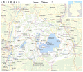
ચિત્ર:Karte Chiemgau.png
Appearance

આ પૂર્વાવલોકનનું કદ: ૬૯૧ × ૬૦૦ પિક્સેલ. અન્ય આવર્તનો: ૨૭૭ × ૨૪૦ પિક્સેલ | ૫૫૩ × ૪૮૦ પિક્સેલ | ૮૮૫ × ૭૬૮ પિક્સેલ | ૧,૧૮૦ × ૧,૦૨૪ પિક્સેલ | ૨,૧૫૫ × ૧,૮૭૦ પિક્સેલ.
મૂળભુત ફાઇલ (૨,૧૫૫ × ૧,૮૭૦ પીક્સલ, ફાઇલનું કદ: ૧.૩૩ MB, MIME પ્રકાર: image/png)
ફાઇલનો ઇતિહાસ
તારીખ/સમય ઉપર ક્લિક કરવાથી તે સમયે ફાઇલ કેવી હતી તે જોવા મળશે.
| તારીખ/સમય | લઘુચિત્ર | પરિમાણો | સભ્ય | ટિપ્પણી | |
|---|---|---|---|---|---|
| વર્તમાન | ૦૫:૩૨, ૫ જૂન ૨૦૧૫ |  | ૨,૧૫૫ × ૧,૮૭૦ (૧.૩૩ MB) | Cmdrjameson | Compressed with pngout. Reduced by 829kB (37% decrease). |
| ૦૩:૨૮, ૭ નવેમ્બર ૨૦૦૯ |  | ૨,૧૫૫ × ૧,૮૭૦ (૨.૧૪ MB) | Chumwa | Hemhofer Seenplatte → Eggstätt-Hemhofer Seenplatte | |
| ૦૨:૪૫, ૫ નવેમ્બર ૨૦૦૯ |  | ૨,૧૫૫ × ૧,૮૭૦ (૨.૧૪ MB) | Chumwa | Chiemseeinseln gehören zum Lkr. Rosenheim | |
| ૧૨:૨૧, ૪ નવેમ્બર ૨૦૦૯ |  | ૨,૧૫૫ × ૧,૮૭૦ (૨.૧૪ MB) | Chumwa | {{Information |Description={{de|Karte: Chiemgau}} {{en|Map: Chiemgau}} |Author=Maximilian Dörrbecker (Chumwa) |Source=own work, using * OpenStreetMap data for the background * [[:File:Germany_location_map.svg|t |
ફાઇલનો વપરાશ
આ ફાઇલને કોઇ પાનાં વાપરતા નથી.
ફાઇલનો વ્યાપક ઉપયોગ
નીચેની બીજી વિકિઓ આ ફાઈલ વાપરે છે:
- an.wikipedia.org પર વપરાશ
- ar.wikipedia.org પર વપરાશ
- arz.wikipedia.org પર વપરાશ
- ca.wikipedia.org પર વપરાશ
- ceb.wikipedia.org પર વપરાશ
- de.wikipedia.org પર વપરાશ
- de.wikivoyage.org પર વપરાશ
- en.wikipedia.org પર વપરાશ
- eo.wikipedia.org પર વપરાશ
- es.wikipedia.org પર વપરાશ
- eu.wikipedia.org પર વપરાશ
- fr.wikipedia.org પર વપરાશ
- hu.wikipedia.org પર વપરાશ
- it.wikipedia.org પર વપરાશ
- nl.wikipedia.org પર વપરાશ
- pl.wikipedia.org પર વપરાશ
- pl.wikivoyage.org પર વપરાશ
- ro.wikipedia.org પર વપરાશ
- ru.wikipedia.org પર વપરાશ
- sr.wikipedia.org પર વપરાશ
- www.wikidata.org પર વપરાશ
