
ચિત્ર:Map-of-southeast-asia 900 CE.png
આ પૂર્વાવલોકનનું કદ: ૪૨૬ × ૬૦૦ પિક્સેલ. અન્ય આવર્તનો: ૧૭૦ × ૨૪૦ પિક્સેલ | ૩૪૧ × ૪૮૦ પિક્સેલ | ૭૯૧ × ૧,૧૧૪ પિક્સેલ.
મૂળભુત ફાઇલ (૭૯૧ × ૧,૧૧૪ પીક્સલ, ફાઇલનું કદ: ૧૮૨ KB, MIME પ્રકાર: image/png)
khmerempire3.jpg
સારાંશ:
| વર્ણન |
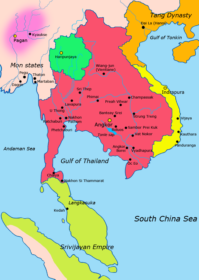
English: Map of Southeast Asia circa 900 CE, showing the Khmer Empire in red, Champa in yellow and Haripunjaya in light Green plus additional surrounding states.
sources i used for this work include http://ecaimaps.berkeley.edu/animations/2003_03_khmer_animation.swf http://www.britannica.com/EBchecked/media/3395/Khmer-empire-1200 Atlas of world history, Patrick Karl O'brien Societies, Networks, and Transitions: A Global History, Volume B. Craig A.Lockard http://upload.wikimedia.org/wikipedia/commons/thumb/4/45/Srivijaya_Empire.svg/2000px-Srivijaya_Empire.svg.png File:DvaravatiMapThailand.png http://upload.wikimedia.org/wikipedia/commons/e/eb/Thailand_2002_CIA_map.jpgBahasa Indonesia: Peta Asia Tenggara sekitar tahun 900 M, menampilkan Kerajaan Khmer dengan warna merah, Champa dengan warna kuning dan Haripunjaya dengan warna hijau beserta beberapa negara-negara lainnya. |
|||
| તારીખ | ||||
| સ્રોત | પોતાની રચના | |||
| લેખક | Javierfv1212 | |||
| અન્ય આવૃત્તિઓ |
|


પરવાના
હું, આ કાર્યનો પ્રકાશનાધિકાર ધારક, તેને નીચેના પરવાના હેઠળ અહીં પ્રકાશીત કરૂં છું:
| આ ફાઈલ વપરાશની પરવાનગી : Creative Commons CC0 1.0 Universal Public Domain Dedication. | |
| આ રચના સાથે સંકળાયેલી વ્યક્તિએ આ રચનાના સર્વ વૈશ્વીક પ્રકાશન અધિકારોને દસ્તાવેજ (deed) દ્વારપબ્લીક ડોમેન public domainમાં અર્પિત કર્યાં છે. તમે આની નકલ કરી શકો, વહેંચી શકો, ધંધાદારી કારનો માટે પણ. આ માટે કોઈ પણ પરવાનગી લેવાની જરૂર નથી
|
ફાઇલનો ઇતિહાસ
તારીખ/સમય ઉપર ક્લિક કરવાથી તે સમયે ફાઇલ કેવી હતી તે જોવા મળશે.
| તારીખ/સમય | લઘુચિત્ર | પરિમાણો | સભ્ય | ટિપ્પણી | |
|---|---|---|---|---|---|
| વર્તમાન | ૧૯:૪૩, ૮ એપ્રિલ ૨૦૧૧ | | ૭૯૧ × ૧,૧૧૪ (૧૮૨ KB) | Ras67 | cropped |
| ૦૭:૪૩, ૨૮ માર્ચ ૨૦૧૧ |  | ૮૦૦ × ૧,૧૨૫ (૨૨૨ KB) | Javierfv1212 | {{Information |Description ={{en|1=Map of South-east asia circa 900 CE, showing the Khmer Empire in red, Champa in yellow and Haripunjaya in light Green plus additional surrounding states. sources i used for this work include http://ecaimaps.berkele |
ફાઇલનો વપરાશ
આ ફાઇલ માં નીચેનું પાનું વપરાયેલું છે:
ફાઇલનો વ્યાપક ઉપયોગ
નીચેની બીજી વિકિઓ આ ફાઈલ વાપરે છે:
- af.wikipedia.org પર વપરાશ
- ar.wikipedia.org પર વપરાશ
- azb.wikipedia.org પર વપરાશ
- az.wikipedia.org પર વપરાશ
- bg.wikipedia.org પર વપરાશ
- ceb.wikipedia.org પર વપરાશ
- cs.wikipedia.org પર વપરાશ
- el.wikipedia.org પર વપરાશ
- en.wikipedia.org પર વપરાશ
- eo.wikipedia.org પર વપરાશ
- et.wikipedia.org પર વપરાશ
- eu.wikipedia.org પર વપરાશ
- fa.wikipedia.org પર વપરાશ
- fi.wikipedia.org પર વપરાશ
- fr.wikipedia.org પર વપરાશ
- he.wikipedia.org પર વપરાશ
- id.wikipedia.org પર વપરાશ
- it.wikipedia.org પર વપરાશ
- ja.wikipedia.org પર વપરાશ
- ka.wikipedia.org પર વપરાશ
- km.wikipedia.org પર વપરાશ
- lo.wikipedia.org પર વપરાશ
- lt.wikipedia.org પર વપરાશ
- mg.wikipedia.org પર વપરાશ
- ml.wikipedia.org પર વપરાશ
- mn.wikipedia.org પર વપરાશ
આ ફાઇલના વધુ વૈશ્વિક વપરાશ જુઓ.