
ચિત્ર:Mt Kailash sat.jpg

આ પૂર્વાવલોકનનું કદ: ૮૦૦ × ૫૭૫ પિક્સેલ. અન્ય આવર્તનો: ૩૨૦ × ૨૩૦ પિક્સેલ | ૬૪૦ × ૪૬૦ પિક્સેલ | ૧,૦૨૪ × ૭૩૬ પિક્સેલ | ૧,૧૫૨ × ૮૨૮ પિક્સેલ.
મૂળભુત ફાઇલ (૧,૧૫૨ × ૮૨૮ પીક્સલ, ફાઇલનું કદ: ૬૫૨ KB, MIME પ્રકાર: image/jpeg)
સારાંશ:
| વર્ણન |
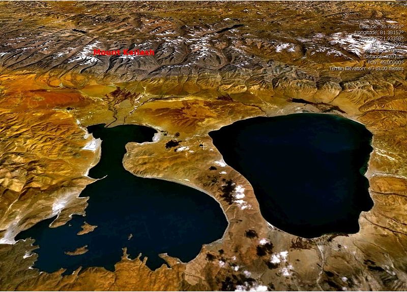
English: Landsat7 Satellite view of the Mount Kailash, draped over SRTM DEM with en:Lake Manasarovar (right) and en:Lake Rakshastal (left) in the foreground. (Image made with the visualisation software NASA World Wind (Open Source))
Please move UP caption Mount Kailash Image:Mt Kailash sat.jpgPlease move UP caption Mount Kailash to enable mount kailash peak visible.Thanks. |
| તારીખ | ૧ મે ૨૦૦૫ (original upload date) |
| સ્રોત | Transferred from en.wikipedia to Commons. |
| લેખક | The original uploader was Moumine at અંગ્રેજી વિકિપીડિયા. |
પરવાના
| આ ફાઈલ વપરાશની પરવાનગી : Creative Commons Attribution-Share Alike 3.0 Unported license. Subject to disclaimers. | ||
| ||
| GFDL licensing update ના ભાગ રૂપે આ પરવાનાનો ટેગ ફાઈલ પર લગાડવામાં આવ્યો છે. |

|
આ રચનાની નકલ કરવા, વિતરણ અને સુધારો કરવા માટે GNU Free Documentation License, આવૃત્તિ 1.2 કે અન્ય આગળની આવૃત્તિ Free Software Foundation હેઠળ પરવાનગી છે; જેમાં કોઈ Invariant Sections, no Front-Cover Texts, and no Back-Cover Texts નથી. આ પરવાનાની પ્રત GNU Free Documentation License વિભાગમાં છે. Subject to disclaimers. |
અસલ - મૂળ અપલોડનો લોગ
The original description page was here. All following user names refer to en.wikipedia.
- 2005-05-01 22:31 Moumine 1152×828×8 (667457 bytes) {{gfdl}} Landsat7 Satellite view of the Mount Kailash, draped over SRTM DEM with [[Lake Manasarowar]] (right) and [[Lake Rakshastal]] (left) in the foreground. (Image made with the visualisation software NASA World Wind (Open Source))
ફાઇલનો ઇતિહાસ
તારીખ/સમય ઉપર ક્લિક કરવાથી તે સમયે ફાઇલ કેવી હતી તે જોવા મળશે.
| તારીખ/સમય | લઘુચિત્ર | પરિમાણો | સભ્ય | ટિપ્પણી | |
|---|---|---|---|---|---|
| વર્તમાન | ૧૨:૧૬, ૭ જાન્યુઆરી ૨૦૦૮ | | ૧,૧૫૨ × ૮૨૮ (૬૫૨ KB) | File Upload Bot (Magnus Manske) | {{BotMoveToCommons|en.wikipedia}} {{Information |Description={{en|Landsat7 Satellite view of the Mount Kailash, draped over SRTM DEM with en:Lake Manasarovar (right) and en:Lake Rakshastal (left) in the foreground. (Image made with the visualis |
ફાઇલનો વપરાશ
આ ફાઇલ માં નીચેનું પાનું વપરાયેલું છે:
ફાઇલનો વ્યાપક ઉપયોગ
નીચેની બીજી વિકિઓ આ ફાઈલ વાપરે છે:
- bg.wikipedia.org પર વપરાશ
- bh.wikipedia.org પર વપરાશ
- bn.wikipedia.org પર વપરાશ
- ceb.wikipedia.org પર વપરાશ
- cs.wikipedia.org પર વપરાશ
- cv.wikipedia.org પર વપરાશ
- cy.wikipedia.org પર વપરાશ
- de.wikipedia.org પર વપરાશ
- en.wikipedia.org પર વપરાશ
- es.wikipedia.org પર વપરાશ
- fr.wikipedia.org પર વપરાશ
- hi.wikipedia.org પર વપરાશ
- hu.wikipedia.org પર વપરાશ
- it.wikipedia.org પર વપરાશ
- ka.wikipedia.org પર વપરાશ
- kn.wikipedia.org પર વપરાશ
- ko.wikipedia.org પર વપરાશ
- ky.wikipedia.org પર વપરાશ
- lt.wikipedia.org પર વપરાશ
- mai.wikipedia.org પર વપરાશ
- ml.wikipedia.org પર વપરાશ
- ne.wikipedia.org પર વપરાશ
- nl.wikipedia.org પર વપરાશ
- or.wikipedia.org પર વપરાશ
- pl.wikipedia.org પર વપરાશ
- pnb.wikipedia.org પર વપરાશ
- pt.wikipedia.org પર વપરાશ
- ru.wikipedia.org પર વપરાશ
આ ફાઇલના વધુ વૈશ્વિક વપરાશ જુઓ.