
ચિત્ર:Munnar Top station.jpg

આ પૂર્વાવલોકનનું કદ: ૮૦૦ × ૪૯૪ પિક્સેલ. અન્ય આવર્તનો: ૩૨૦ × ૧૯૭ પિક્સેલ | ૬૪૦ × ૩૯૫ પિક્સેલ | ૧,૦૨૪ × ૬૩૨ પિક્સેલ | ૧,૨૪૬ × ૭૬૯ પિક્સેલ.
મૂળભુત ફાઇલ (૧,૨૪૬ × ૭૬૯ પીક્સલ, ફાઇલનું કદ: ૯૦૫ KB, MIME પ્રકાર: image/jpeg)
સારાંશ:
| વર્ણન |
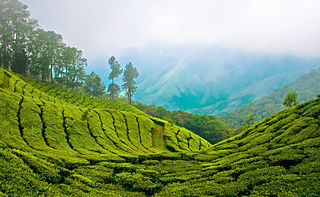
English: Top station, 41 km (1hr) from Munnar is aptly named, as it is home to some of the highest tea plantations in India. It lies on the state border between Kerala and Tamilnadu and commands a panoramic view of rolling green hills. |
||
| તારીખ | |||
| સ્રોત | Top Station - Munnar | ||
| લેખક | Bimal K C from Cochin, India | ||
| પરવાનગી (આ ફાઈલનો ફરી ઉપયોગ) |
આ ફાઈલ વપરાશની પરવાનગી : Creative Commons Attribution 2.0 Generic license.
|
|
ફાઇલનો ઇતિહાસ
તારીખ/સમય ઉપર ક્લિક કરવાથી તે સમયે ફાઇલ કેવી હતી તે જોવા મળશે.
| તારીખ/સમય | લઘુચિત્ર | પરિમાણો | સભ્ય | ટિપ્પણી | |
|---|---|---|---|---|---|
| વર્તમાન | ૧૮:૩૫, ૬ એપ્રિલ ૨૦૧૧ | | ૧,૨૪૬ × ૭૬૯ (૯૦૫ KB) | Ras67 | cropped |
| ૧૭:૩૩, ૧૨ ઓગસ્ટ ૨૦૦૮ |  | ૧,૨૮૦ × ૮૦૩ (૯૫૨ KB) | Challiyan | {{Information |Description= Top station, 41 km (1hr) from Munnar is aptly named, as it is home to some of the highest tea plantations in India. It lies on the state border between Kerala and Tamilnadu and commands a panoramic view of rolling green hills. |
ફાઇલનો વપરાશ
ફાઇલનો વ્યાપક ઉપયોગ
નીચેની બીજી વિકિઓ આ ફાઈલ વાપરે છે:
- bo.wikipedia.org પર વપરાશ
- cs.wikipedia.org પર વપરાશ
- de.wikipedia.org પર વપરાશ
- en.wikipedia.org પર વપરાશ
- en.wikivoyage.org પર વપરાશ
- es.wikipedia.org પર વપરાશ
- fr.wikipedia.org પર વપરાશ
- id.wikipedia.org પર વપરાશ
- incubator.wikimedia.org પર વપરાશ
- kn.wikipedia.org પર વપરાશ
- ml.wikipedia.org પર વપરાશ
- കേരളം
- മൂന്നാർ
- വിക്കിപീഡിയ:തിരഞ്ഞെടുക്കാവുന്ന ചിത്രങ്ങൾ/നിലവറ 19
- വിക്കിപീഡിയ:തിരഞ്ഞെടുത്ത ചിത്രങ്ങൾ/മേയ് 2016
- വിക്കിപീഡിയ:തിരഞ്ഞെടുത്ത ചിത്രങ്ങൾ/08-05-2016
- വിക്കിപീഡിയ:തിരഞ്ഞെടുത്ത ചിത്രങ്ങൾ/09-05-2016
- വിക്കിപീഡിയ:തിരഞ്ഞെടുത്ത ചിത്രങ്ങൾ/10-05-2016
- വിക്കിപീഡിയ:തിരഞ്ഞെടുത്ത ചിത്രങ്ങൾ/11-05-2016
- വിക്കിപീഡിയ:തിരഞ്ഞെടുത്ത ചിത്രങ്ങൾ/12-05-2016
- വിക്കിപീഡിയ:തിരഞ്ഞെടുത്ത ചിത്രങ്ങൾ/13-05-2016
- വിക്കിപീഡിയ:തിരഞ്ഞെടുത്ത ചിത്രങ്ങൾ/14-05-2016
- nl.wikipedia.org પર વપરાશ
- no.wiktionary.org પર વપરાશ
- pl.wikipedia.org પર વપરાશ
- ru.wikipedia.org પર વપરાશ
- sa.wikipedia.org પર વપરાશ
- sv.wikipedia.org પર વપરાશ
- ta.wikipedia.org પર વપરાશ
- te.wikipedia.org પર વપરાશ
- ur.wikipedia.org પર વપરાશ
- war.wikipedia.org પર વપરાશ