
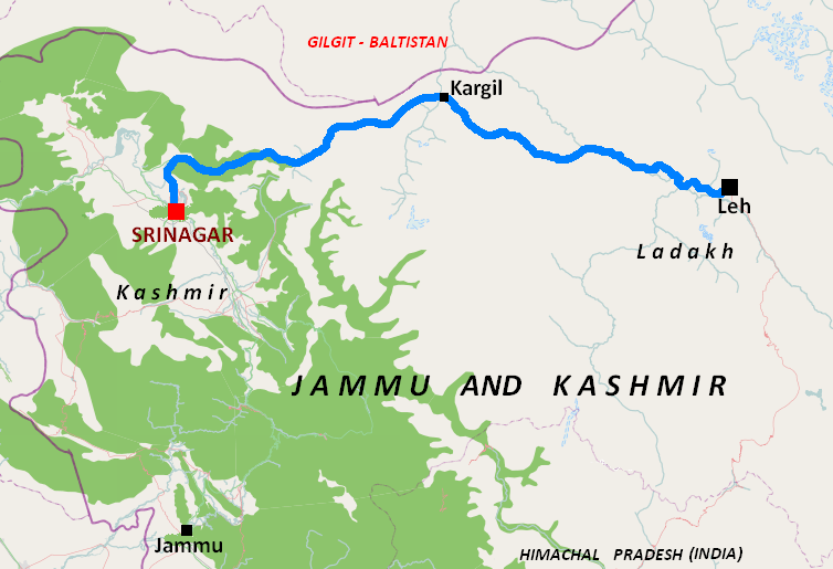
ચિત્ર:Nh1d.PNG
આથી વધુ ઘનત્વ ઉપલબ્ધ નથી.
Nh1d.PNG (૭૫૪ × ૫૧૫ પીક્સલ, ફાઇલનું કદ: ૯૯ KB, MIME પ્રકાર: image/png)
સારાંશ:
| વર્ણન | |
| તારીખ | |
| સ્રોત | Basic map is from OpenStreetMaps (Cycle Map layer); names and locations added by me taking reference from en:File:Kashmir map.svg |
| લેખક |
|
પરવાના
આ ફાઈલ વપરાશની પરવાનગી : Creative Commons Attribution-Share Alike 2.0 Generic license.
- તમે મુક્ત છો:
- વહેંચવા – નકલ કરવા, વિતરણ કરવા અને રચનાઓ મોકલવા
- રીમિક્સ કરવા કે મઠારવા – રચના અપનાવવા
- નીચેની શરત હેઠળ:
- આરોપણ – તમારે આ રચનાનો ઉપયોગ કરવા માટે લેખક કે પ્રકાશન અધિકાર ધારકની યોગ્ય માહિતી, પરવાનગી (લાયસન્સ)ની કડી અને તેમાં ફેરફાર કર્યો હોય તો તેનો ઉલ્લેખ કરવો જ પડશે. તમે આ સત્તા અનુસાર જ આ રચનાનો પ્રયોગ થવો જોઈએ, પણ તેઓ તમને અથવા તમારા ઉપયોગ સાથે સંમત થાય છે તે રીતે નહીં.
- શેર- અલાઈક (બિન ભેદભાવ વહેંચણી) – તમે જો આ રચનાને બદલશો, તેમાં ફેરફાર કરશો અથવા તેના પર આધારિત કોઇ કાર્ય બનાવશો તો તમારે પરિણામી કાર્યને તે જ અથવા અનુરૂપ પરવાનગી હેઠળ જ પ્રકાશિત કરવું પડશે.
| Description |
This map was created from OpenStreetMap project data, collected by the community. This map may be incomplete, and may contain errors. Don't rely solely on it for navigation. |
|||
| તારીખ | (see file history) | |||
| સ્રોત | openstreetmap.org | |||
| રચયિતા |
OpenStreetMap contributors |
|||
| પરવાનગી (આ ફાઈલનો ફરી ઉપયોગ) |
OpenStreetMap data is available under the Open Database License (details). Map tiles are licensed under the Creative Commons Attribution-ShareAlike 2.0 license (CC-BY-SA 2.0).
આ ફાઈલ વપરાશની પરવાનગી : Creative Commons Attribution-Share Alike 2.0 Generic license.
|
|||
| Georeferencing | If inappropriate please set warp_status = skip to hide. |
અસલ - મૂળ અપલોડનો લોગ
Transferred from en.wikipedia to Commons by Ashok modhvadia.
The original description page was here. All following user names refer to en.wikipedia.
- 2011-03-21 07:57 Tatiraju.rishabh 754×515× (101876 bytes) {Information |Description= {{en|Map of [[National Highway 1D (India)]]}} |Source=Basic map is from OpenStreetMaps (Cycle Map layer); names and locations added by me taking reference from <nowiki>[[File:Kashmir map.svg]] |Date=2011-03-21 |Author= </nowiki>
ફાઇલનો ઇતિહાસ
તારીખ/સમય ઉપર ક્લિક કરવાથી તે સમયે ફાઇલ કેવી હતી તે જોવા મળશે.
| તારીખ/સમય | લઘુચિત્ર | પરિમાણો | સભ્ય | ટિપ્પણી | |
|---|---|---|---|---|---|
| વર્તમાન | ૧૫:૨૦, ૨૮ નવેમ્બર ૨૦૧૩ | | ૭૫૪ × ૫૧૫ (૯૯ KB) | Ashok modhvadia | {{Information |Description={{en|en:Category:OpenStreetMap maps}} |Source=Transferred from [http://en.wikipedia.org en.wikipedia]; transfer was stated to be made by User:Ashok modhvadia.<br/> (Original text : ''Basic map is from OpenStreetMaps... |
ફાઇલનો વપરાશ
આ ફાઇલ માં નીચેનું પાનું વપરાયેલું છે:
ફાઇલનો વ્યાપક ઉપયોગ
નીચેની બીજી વિકિઓ આ ફાઈલ વાપરે છે:
- bn.wikipedia.org પર વપરાશ
- de.wikipedia.org પર વપરાશ
- en.wikipedia.org પર વપરાશ
- ml.wikipedia.org પર વપરાશ
- ta.wikipedia.org પર વપરાશ
- www.wikidata.org પર વપરાશ