
ચિત્ર:Orissa State map.svg

Size of this PNG preview of this SVG file: ૭૪૦ × ૫૯૯ પિક્સેલ. અન્ય આવર્તનો: ૨૯૬ × ૨૪૦ પિક્સેલ | ૫૯૩ × ૪૮૦ પિક્સેલ | ૯૪૮ × ૭૬૮ પિક્સેલ | ૧,૨૬૪ × ૧,૦૨૪ પિક્સેલ | ૨,૫૨૯ × ૨,૦૪૮ પિક્સેલ | ૨,૧૮૪ × ૧,૭૬૯ પિક્સેલ.
મૂળભુત ફાઇલ (SVG ફાઇલ, માત્ર ૨,૧૮૪ × ૧,૭૬૯ પીક્સલ, ફાઇલનું કદ: ૧.૭૭ MB)
સારાંશ:
| શીર્ષક |
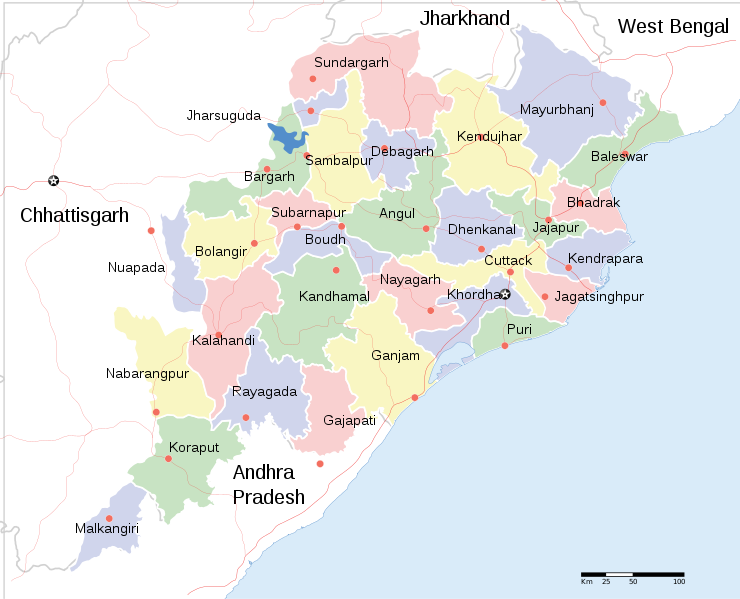
English: Locator map of Indian state, Odisha. |
| Description |
Locator map of the state of Orissa, India with district boundaries. |
| તારીખ | |
| સ્રોત |
પોતાની રચના |
| રચયિતા | |
| પરવાનગી (આ ફાઈલનો ફરી ઉપયોગ) |
હું, આ કાર્યનો પ્રકાશનાધિકાર ધારક, તેને નીચેના પરવાના હેઠળ અહીં પ્રકાશીત કરૂં છું: આ ફાઈલ વપરાશની પરવાનગી : Creative Commons Attribution-Share Alike 3.0 Unported license.
|
| Geotemporal data | |
| Date depicted | second half of 20 century અને 21 century |
| Georeferencing | If inappropriate please set warp_status = skip to hide. |
| Archival data | |
| નોંધ | Part of WikiProject India Maps |
| અન્ય આવૃત્તિઓ |
[]
|


ફાઇલનો ઇતિહાસ
તારીખ/સમય ઉપર ક્લિક કરવાથી તે સમયે ફાઇલ કેવી હતી તે જોવા મળશે.
| તારીખ/સમય | લઘુચિત્ર | પરિમાણો | સભ્ય | ટિપ્પણી | |
|---|---|---|---|---|---|
| વર્તમાન | ૦૧:૪૮, ૧૧ જૂન ૨૦૨૦ | | ૨,૧૮૪ × ૧,૭૬૯ (૧.૭૭ MB) | শরদিন্দু ভট্টাচার্য্য | File uploaded using svgtranslate tool (https://svgtranslate.toolforge.org/). Added translation for bn. |
| ૧૫:૦૫, ૧ એપ્રિલ ૨૦૧૧ |  | ૨,૧૮૪ × ૧,૭૬૯ (૧.૭૬ MB) | Jayantanth | == {{int:filedesc}} == {{WikiProject_India_Maps |Title=Orissa locator map |Description=Locator map of the state of Orissa, India with district boundaries. |Source= |Date=2008-12-29 |Author={{User:PlaneMad/Info}} }} [[Category:WikiPr |
ફાઇલનો વપરાશ
આ ફાઇલને કોઇ પાનાં વાપરતા નથી.
ફાઇલનો વ્યાપક ઉપયોગ
નીચેની બીજી વિકિઓ આ ફાઈલ વાપરે છે:
- bcl.wikipedia.org પર વપરાશ
- bn.wikipedia.org પર વપરાશ
- cv.wikipedia.org પર વપરાશ
- en.wikipedia.org પર વપરાશ
- fa.wikipedia.org પર વપરાશ
- fr.wikipedia.org પર વપરાશ
- ha.wikipedia.org પર વપરાશ
- hr.wikipedia.org પર વપરાશ
- hy.wikipedia.org પર વપરાશ
- it.wikipedia.org પર વપરાશ
- mai.wikipedia.org પર વપરાશ
- ml.wikipedia.org પર વપરાશ
- mn.wikipedia.org પર વપરાશ
- ne.wikipedia.org પર વપરાશ
- pa.wikipedia.org પર વપરાશ
- ru.wikipedia.org પર વપરાશ
- sa.wikipedia.org પર વપરાશ
- sd.wikipedia.org પર વપરાશ
- tg.wikipedia.org પર વપરાશ
- ur.wikipedia.org પર વપરાશ
- zh.wikipedia.org પર વપરાશ
આ ફાઇલના વધુ વૈશ્વિક વપરાશ જુઓ.