
ચિત્ર:Portland or 1897.png
આ પૂર્વાવલોકનનું કદ: ૬૯૬ × ૫૯૯ પિક્સેલ. અન્ય આવર્તનો: ૨૭૯ × ૨૪૦ પિક્સેલ | ૫૫૮ × ૪૮૦ પિક્સેલ | ૮૯૨ × ૭૬૮ પિક્સેલ | ૧,૧૯૦ × ૧,૦૨૪ પિક્સેલ | ૧,૮૧૧ × ૧,૫૫૯ પિક્સેલ.
મૂળભુત ફાઇલ (૧,૮૧૧ × ૧,૫૫૯ પીક્સલ, ફાઇલનું કદ: ૫.૩૮ MB, MIME પ્રકાર: image/png)
સારાંશ:
| વર્ણન |
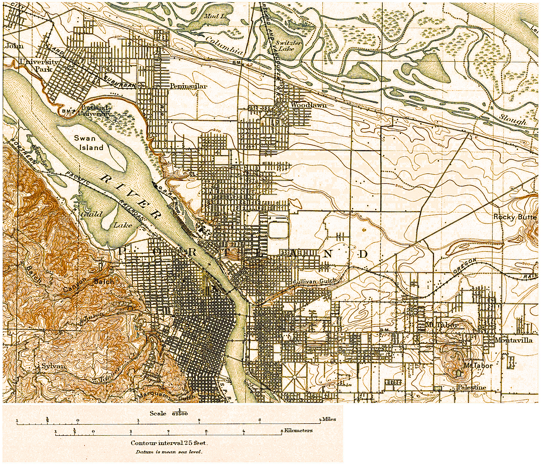
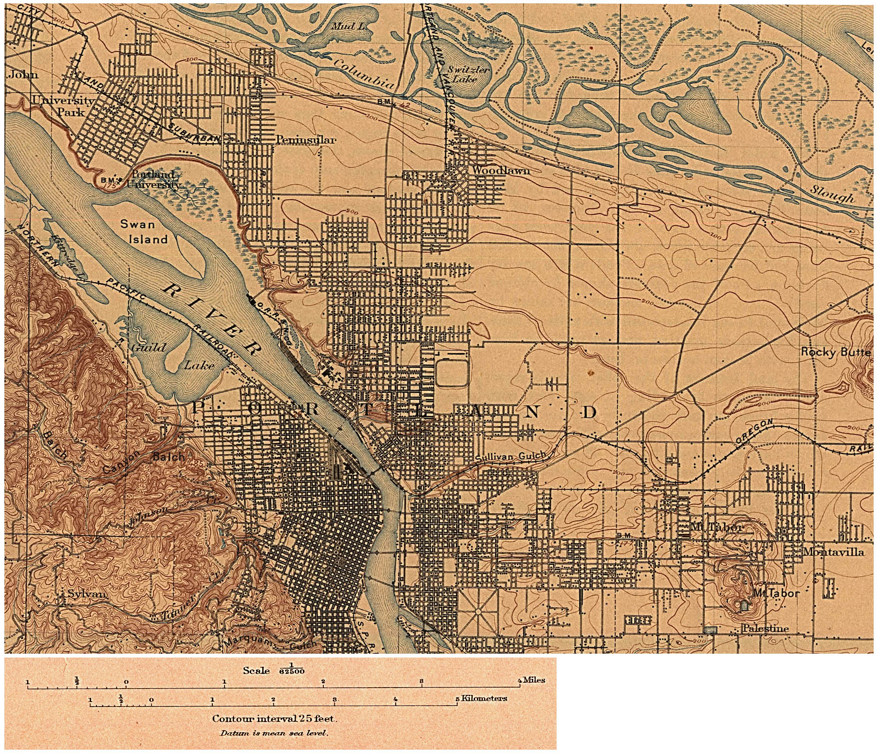
English: Topographic map of Portland, U.S. as of 1897. I processed the original scan http://www.lib.utexas.edu/maps/historical/portland_or_1897.jpg to remove 100+ years of aging ink and paper by color replacements and sharpening. |
| તારીખ | |
| સ્રોત | http://www.lib.utexas.edu/maps/historical/portland_or_1897.jpg |
| લેખક | U.S. Geological Survey + EncMstr |
પરવાના
This work is in the public domain in the United States because it is a work prepared by an officer or employee of the United States Government as part of that person’s official duties under the terms of Title 17, Chapter 1, Section 105 of the US Code.
Note: This only applies to original works of the Federal Government and not to the work of any individual U.S. state, territory, commonwealth, county, municipality, or any other subdivision. This template also does not apply to postage stamp designs published by the United States Postal Service since 1978. (See § 313.6(C)(1) of Compendium of U.S. Copyright Office Practices). It also does not apply to certain US coins; see The US Mint Terms of Use.
|
 | |
| પ્રકાશન કાયદા હેઠળ અને તેને મળતા આવતાં આ ફાઈલ ને મુક્ત ગણાઈ છે | ||
ફાઇલનો ઇતિહાસ
તારીખ/સમય ઉપર ક્લિક કરવાથી તે સમયે ફાઇલ કેવી હતી તે જોવા મળશે.
| તારીખ/સમય | લઘુચિત્ર | પરિમાણો | સભ્ય | ટિપ્પણી | |
|---|---|---|---|---|---|
| વર્તમાન | ૦૫:૫૮, ૩૦ જાન્યુઆરી ૨૦૦૯ | | ૧,૮૧૧ × ૧,૫૫૯ (૫.૩૮ MB) | EncMstr | {{Information |Description={{en|1=Topographic map of w:Portland, Oregon, U.S. as of 1897. I processed the original scan http://www.lib.utexas.edu/maps/historical/portland_or_1897.jpg to remove 100+ years of aging ink and paper by color replacements |
ફાઇલનો વપરાશ
આ ફાઇલ માં નીચેનું પાનું વપરાયેલું છે:
ફાઇલનો વ્યાપક ઉપયોગ
નીચેની બીજી વિકિઓ આ ફાઈલ વાપરે છે:
- en.wikipedia.org પર વપરાશ
- fa.wikipedia.org પર વપરાશ
- hi.wikipedia.org પર વપરાશ
- ja.wikipedia.org પર વપરાશ
- mk.wikipedia.org પર વપરાશ
- ru.wikipedia.org પર વપરાશ