
ચિત્ર:San Francisco Bay Bridges map en.svg

Size of this PNG preview of this SVG file: ૨૭૦ × ૩૩૦ પિક્સેલ. અન્ય આવર્તનો: ૧૯૬ × ૨૪૦ પિક્સેલ | ૩૯૩ × ૪૮૦ પિક્સેલ | ૬૨૮ × ૭૬૮ પિક્સેલ | ૮૩૮ × ૧,૦૨૪ પિક્સેલ | ૧,૬૭૬ × ૨,૦૪૮ પિક્સેલ.
મૂળભુત ફાઇલ (SVG ફાઇલ, માત્ર ૨૭૦ × ૩૩૦ પીક્સલ, ફાઇલનું કદ: ૩૨૧ KB)
સારાંશ:
| વર્ણન |
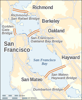
English: Map of the bridges of San Francisco Bay — in the San Francisco Bay Area, California.
|
| તારીખ | |
| સ્રોત |
પોતાની રચના This W3C-unspecified vector image was created with Inkscape . |
| લેખક | Alexrk |
| અન્ય આવૃત્તિઓ | Derivative works of this file: San Francisco Bay Bridges map ar.pngDerivative works of this file: San Francisco Bay Bridges map ar.svg |

|
This map has been made or improved in the German Kartenwerkstatt (Map Lab). You can propose maps to improve as well.
|

|
This SVG file contains embedded text that can be translated into your language, using any capable SVG editor, text editor or the SVG Translate tool. For more information see: About translating SVG files. |
પરવાના
હું, આ કાર્યનો પ્રકાશનાધિકાર ધારક, તેને નીચેના પરવાના હેઠળ અહીં પ્રકાશીત કરૂં છું:
આ ફાઈલ વપરાશની પરવાનગી : Creative Commons Attribution-Share Alike 3.0 Unported license.
- તમે મુક્ત છો:
- વહેંચવા – નકલ કરવા, વિતરણ કરવા અને રચનાઓ મોકલવા
- રીમિક્સ કરવા કે મઠારવા – રચના અપનાવવા
- નીચેની શરત હેઠળ:
- આરોપણ – તમારે આ રચનાનો ઉપયોગ કરવા માટે લેખક કે પ્રકાશન અધિકાર ધારકની યોગ્ય માહિતી, પરવાનગી (લાયસન્સ)ની કડી અને તેમાં ફેરફાર કર્યો હોય તો તેનો ઉલ્લેખ કરવો જ પડશે. તમે આ સત્તા અનુસાર જ આ રચનાનો પ્રયોગ થવો જોઈએ, પણ તેઓ તમને અથવા તમારા ઉપયોગ સાથે સંમત થાય છે તે રીતે નહીં.
- શેર- અલાઈક (બિન ભેદભાવ વહેંચણી) – તમે જો આ રચનાને બદલશો, તેમાં ફેરફાર કરશો અથવા તેના પર આધારિત કોઇ કાર્ય બનાવશો તો તમારે પરિણામી કાર્યને તે જ અથવા અનુરૂપ પરવાનગી હેઠળ જ પ્રકાશિત કરવું પડશે.
ફાઇલનો ઇતિહાસ
તારીખ/સમય ઉપર ક્લિક કરવાથી તે સમયે ફાઇલ કેવી હતી તે જોવા મળશે.
| તારીખ/સમય | લઘુચિત્ર | પરિમાણો | સભ્ય | ટિપ્પણી | |
|---|---|---|---|---|---|
| વર્તમાન | ૧૯:૪૪, ૨૪ જુલાઇ ૨૦૦૮ | | ૨૭૦ × ૩૩૦ (૩૨૧ KB) | Alexrk | |
| ૨૦:૪૪, ૧૯ જુલાઇ ૨૦૦૮ |  | ૨૭૦ × ૩૩૦ (૩૨૧ KB) | Alexrk | 2 Scales: km & mi | |
| ૧૯:૩૧, ૧૯ જુલાઇ ૨૦૦૮ |  | ૨૭૦ × ૩૩૦ (૩૧૮ KB) | Alexrk | Scale, Size | |
| ૧૯:૧૯, ૧૯ જુલાઇ ૨૦૦૮ |  | ૨૮૭ × ૩૪૭ (૩૧૭ KB) | Alexrk | Revise Labels, Background | |
| ૧૯:૧૨, ૧૯ જુલાઇ ૨૦૦૮ |  | ૨૮૭ × ૩૪૭ (૩૦૬ KB) | Alexrk | Mess with fonts | |
| ૧૯:૦૩, ૧૯ જુલાઇ ૨૦૦૮ |  | ૨૮૭ × ૩૪૭ (૩૧૪ KB) | Alexrk | {{Information |Description={{en|1=Locator Map of San Francisco Bay bridges}} |Source=Own work by uploader |Author=Alexrk |Date= |Permission= |other_versions= }} {{ImageUpload|full}} |
ફાઇલનો વપરાશ
આ ફાઇલ માં નીચેનું પાનું વપરાયેલું છે:
ફાઇલનો વ્યાપક ઉપયોગ
નીચેની બીજી વિકિઓ આ ફાઈલ વાપરે છે:
- arz.wikipedia.org પર વપરાશ
- ast.wikipedia.org પર વપરાશ
- bcl.wikipedia.org પર વપરાશ
- bg.wikipedia.org પર વપરાશ
- ca.wikipedia.org પર વપરાશ
- cs.wikipedia.org પર વપરાશ
- de.wikipedia.org પર વપરાશ
- en.wikipedia.org પર વપરાશ
- es.wikipedia.org પર વપરાશ
- fi.wikipedia.org પર વપરાશ
- fr.wikipedia.org પર વપરાશ
- ga.wikipedia.org પર વપરાશ
- he.wikipedia.org પર વપરાશ
- is.wikipedia.org પર વપરાશ
- ml.wikipedia.org પર વપરાશ
- my.wikipedia.org પર વપરાશ
- pt.wikipedia.org પર વપરાશ
- sco.wikipedia.org પર વપરાશ
- sl.wikipedia.org પર વપરાશ
- ta.wikipedia.org પર વપરાશ
- th.wikipedia.org પર વપરાશ
- uk.wikipedia.org પર વપરાશ
આ ફાઇલના વધુ વૈશ્વિક વપરાશ જુઓ.