
ચિત્ર:Tamil distribution.png

આ પૂર્વાવલોકનનું કદ: ૫૩૨ × ૫૯૯ પિક્સેલ. અન્ય આવર્તનો: ૨૧૩ × ૨૪૦ પિક્સેલ | ૪૨૬ × ૪૮૦ પિક્સેલ | ૬૮૨ × ૭૬૮ પિક્સેલ | ૯૦૯ × ૧,૦૨૪ પિક્સેલ | ૧,૬૪૯ × ૧,૮૫૮ પિક્સેલ.
મૂળભુત ફાઇલ (૧,૬૪૯ × ૧,૮૫૮ પીક્સલ, ફાઇલનું કદ: ૫૬૭ KB, MIME પ્રકાર: image/png)
| શીર્ષક |
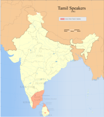
Tamil speakers map |
| Description |
Detail of Image:Tamil speakers map.svg; Areas in India and Sri Lanka where Tamil is spoken (1961). |
| તારીખ | |
| સ્રોત |
પોતાની રચના |
| રચયિતા | |
| પરવાનગી (આ ફાઈલનો ફરી ઉપયોગ) |
હું, આ કાર્યનો પ્રકાશનાધિકાર ધારક, તેને નીચેના પરવાના હેઠળ અહીં પ્રકાશીત કરૂં છું: આ ફાઈલ વપરાશની પરવાનગી : Creative Commons Attribution-Share Alike 3.0 Unported license.
|
| Geotemporal data | |
| Date depicted | second half of 20 century અને 21 century |
| Georeferencing | If inappropriate please set warp_status = skip to hide. |
| Archival data | |
| નોંધ | Part of WikiProject India Maps |
ફાઇલનો ઇતિહાસ
તારીખ/સમય ઉપર ક્લિક કરવાથી તે સમયે ફાઇલ કેવી હતી તે જોવા મળશે.
| તારીખ/સમય | લઘુચિત્ર | પરિમાણો | સભ્ય | ટિપ્પણી | |
|---|---|---|---|---|---|
| વર્તમાન | ૧૭:૦૮, ૧૪ સપ્ટેમ્બર ૨૦૨૧ | | ૧,૬૪૯ × ૧,૮૫૮ (૫૬૭ KB) | Amritsvāraya | Updated the map to 1981 |
| ૦૦:૫૯, ૨૧ મે ૨૦૦૭ |  | ૩૬૬ × ૩૧૯ (૪૩ KB) | Dbachmann | {{WikiProject_India_Maps |Title=Tamil speakers map |Description=Detail of Image:Tamil speakers map.svg; Areas in India and Sri Lanka where Tamil is spoken (1961). |Source= [http://www.himalmag.com/2003/april/images/inside_back_map.jpg Himalag - La |
ફાઇલનો વપરાશ
આ ફાઇલ માં નીચેનું પાનું વપરાયેલું છે:
ફાઇલનો વ્યાપક ઉપયોગ
નીચેની બીજી વિકિઓ આ ફાઈલ વાપરે છે:
- af.wikipedia.org પર વપરાશ
- ar.wikipedia.org પર વપરાશ
- azb.wikipedia.org પર વપરાશ
- ca.wikipedia.org પર વપરાશ
- en.wikipedia.org પર વપરાશ
- Liberation Tigers of Tamil Eelam
- Tamil Nadu
- Tamil language
- Tamils
- Iyer
- List of Tamil people
- George Uglow Pope
- Tamil Jain
- Iyengar
- User talk:Deeceevoice
- Category:Tamil people
- User talk:Princenrsama~enwiki
- User talk:Sivaraj
- Louis Jacolliot
- Music of Tamil Nadu
- Murali Kartik
- Kaarkaathaar
- Hebbar Iyengar
- Eelam
- Alain Daniélou
- Tamil cuisine
- Hinduism in Sri Lanka
- User talk:Paul Raj
- Balakumaran
- Tamil Muslim
- Tamil diaspora
- Category:Tamil festivals
- Category:Tamil diaspora
- User talk:Senthilkumaras
- User:Senthilkumaras
- Category:Tamil actors
- Jaffna kingdom
- Sri Lankan Tamils
- Sangam period
- Tamilakam
- Kongu Vellalar
- Naṟṟiṇai
- Agamudayar
- Karaiyar
- List of Sri Lankan Tamils
- History of Tamil Nadu
- Tamil Brahmin
- Elur Chetty
- User talk:Aadal
- Tamil numerals
આ ફાઇલના વધુ વૈશ્વિક વપરાશ જુઓ.