
ચિત્ર:Azores-map.png

આ પૂર્વાવલોકનનું કદ: ૮૦૦ × ૪૮૯ પિક્સેલ. અન્ય આવર્તનો: ૩૨૦ × ૧૯૫ પિક્સેલ | ૬૪૦ × ૩૯૧ પિક્સેલ | ૧,૦૨૪ × ૬૨૫ પિક્સેલ | ૧,૨૮૦ × ૭૮૨ પિક્સેલ | ૨,૯૬૦ × ૧,૮૦૮ પિક્સેલ.
મૂળભુત ફાઇલ (૨,૯૬૦ × ૧,૮૦૮ પીક્સલ, ફાઇલનું કદ: ૩૫૮ KB, MIME પ્રકાર: image/png)

|
This map image could be re-created using vector graphics as an SVG file. This has several advantages; see Commons:Media for cleanup for more information. If an SVG form of this image is available, please upload it and afterwards replace this template with
{{vector version available|new image name}}.
It is recommended to name the SVG file “Azores-map.svg”—then the template Vector version available (or Vva) does not need the new image name parameter. |
સારાંશ:
| વર્ણન |
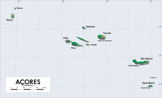
Map of Azores Islands (Portugal)
|
| તારીખ | ૨૧ માર્ચ ૨૦૦૬ (original upload date) |
| સ્રોત | No machine-readable source provided. Own work assumed (based on copyright claims). |
| લેખક | No machine-readable author provided. Varp~commonswiki assumed (based on copyright claims). |
derivative works
Derivative works of this file: Azores Base Map.png
પરવાના
| હું, આ રચનાઓ પ્રકાશન અધિકાર ધારક, આ રચનાને public domain પર પ્રકાશિત કરું છું. આ સમગ્ર વિશ્વમઆં કાર્યરત રહેશે. અમુક દેશોમાં કાયદેસર રીતે તે શક્ય નથી, જો તેમ હોય તો : કો કોઈને પણ કોઈપણ વપરાશ, કોઇ પણ શરત વગર, માટે આ રચના વાપરવાની છૂટ આપું છું સિવાયકે તે શરતો કાયદેસર જરૂરી હોય. |
ફાઇલનો ઇતિહાસ
તારીખ/સમય ઉપર ક્લિક કરવાથી તે સમયે ફાઇલ કેવી હતી તે જોવા મળશે.
| તારીખ/સમય | લઘુચિત્ર | પરિમાણો | સભ્ય | ટિપ્પણી | |
|---|---|---|---|---|---|
| વર્તમાન | ૨૨:૩૦, ૭ નવેમ્બર ૨૦૧૬ | | ૨,૯૬૦ × ૧,૮૦૮ (૩૫૮ KB) | NordNordWest | + 75 km |
| ૨૦:૩૧, ૮ એપ્રિલ ૨૦૦૬ |  | ૨,૯૬૦ × ૧,૮૦૮ (૩૮૦ KB) | Varp~commonswiki | ||
| ૧૮:૦૩, ૭ એપ્રિલ ૨૦૦૬ |  | ૨,૯૬૦ × ૧,૮૦૮ (૩૭૯ KB) | Varp~commonswiki | ||
| ૦૦:૨૪, ૩ એપ્રિલ ૨૦૦૬ |  | ૨,૯૬૦ × ૧,૮૦૮ (૩૨૯ KB) | Varp~commonswiki | ||
| ૦૧:૧૦, ૨૭ માર્ચ ૨૦૦૬ |  | ૨,૯૬૦ × ૧,૮૦૮ (૩૧૯ KB) | Varp~commonswiki | ||
| ૧૭:૫૭, ૨૧ માર્ચ ૨૦૦૬ |  | ૨,૯૬૦ × ૧,૮૦૮ (૩૧૮ KB) | Varp~commonswiki | *Map of Azores Islands (Portugal) *drawn by varp |
ફાઇલનો વપરાશ
આ ફાઇલને કોઇ પાનાં વાપરતા નથી.
ફાઇલનો વ્યાપક ઉપયોગ
નીચેની બીજી વિકિઓ આ ફાઈલ વાપરે છે:
- af.wikipedia.org પર વપરાશ
- als.wikipedia.org પર વપરાશ
- az.wikipedia.org પર વપરાશ
- bg.wikipedia.org પર વપરાશ
- br.wikipedia.org પર વપરાશ
- bs.wikipedia.org પર વપરાશ
- ca.wikipedia.org પર વપરાશ
- de.wikipedia.org પર વપરાશ
- el.wikipedia.org પર વપરાશ
- el.wikivoyage.org પર વપરાશ
- en.wikipedia.org પર વપરાશ
- en.wikiversity.org પર વપરાશ
- en.wikivoyage.org પર વપરાશ
- es.wikipedia.org પર વપરાશ
- et.wikipedia.org પર વપરાશ
- fi.wikivoyage.org પર વપરાશ
- frr.wikipedia.org પર વપરાશ
- fr.wikipedia.org પર વપરાશ
- ga.wikipedia.org પર વપરાશ
- gl.wikipedia.org પર વપરાશ
- he.wikivoyage.org પર વપરાશ
- hsb.wikipedia.org પર વપરાશ
- hu.wikipedia.org પર વપરાશ
- it.wikipedia.org પર વપરાશ
- ja.wikipedia.org પર વપરાશ
- lb.wikipedia.org પર વપરાશ
- lt.wikipedia.org પર વપરાશ
- mr.wikipedia.org પર વપરાશ
- nl.wikipedia.org પર વપરાશ
- pl.wiktionary.org પર વપરાશ
- pt.wikipedia.org પર વપરાશ
- ru.wikipedia.org પર વપરાશ
- ru.wikivoyage.org પર વપરાશ
- simple.wikipedia.org પર વપરાશ
- sl.wikipedia.org પર વપરાશ
- sq.wikipedia.org પર વપરાશ
- sv.wikipedia.org પર વપરાશ
આ ફાઇલના વધુ વૈશ્વિક વપરાશ જુઓ.