
ચિત્ર:Azores satellite photo-NASA.jpg

આ પૂર્વાવલોકનનું કદ: ૮૦૦ × ૬૦૦ પિક્સેલ. અન્ય આવર્તનો: ૩૨૦ × ૨૪૦ પિક્સેલ | ૬૪૦ × ૪૮૦ પિક્સેલ | ૧,૦૨૪ × ૭૬૮ પિક્સેલ | ૧,૨૮૦ × ૯૬૦ પિક્સેલ | ૧,૬૦૦ × ૧,૨૦૦ પિક્સેલ.
મૂળભુત ફાઇલ (૧,૬૦૦ × ૧,૨૦૦ પીક્સલ, ફાઇલનું કદ: ૯૯ KB, MIME પ્રકાર: image/jpeg)
સારાંશ:
| વર્ણન |
Deutsch: Satellitenfoto der Azoren
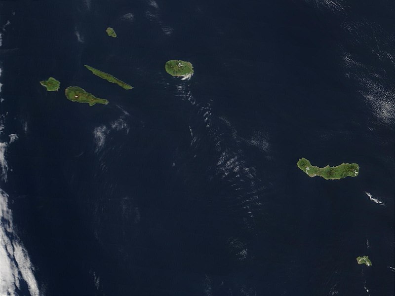
English: Original caption: Hundreds of miles off the coast of Portugal, the nine islands of the Azores chains are stretched out over the Atlantic Ocean. This Moderate Resolution Imaging Spectroradiometer (MODIS) image from the Terra satellite on May 1, 2003, shows seven of the nine islands: (from left to right) Faial, Pico, Sao Jorge, Graciosa (north), Terceira, Sao Miguel, and Santa Maria. |
| તારીખ | |
| સ્રોત | visibleearth.nasa.gov (VE Record ID: 25535) |
| લેખક | Jeff Schmaltz, MODIS Rapid Response Team, NASA/GSFC |
| અન્ય આવૃત્તિઓ | cropped and annotated version: File:Satellite image of The Azores in May 2003.jpg |
પરવાના
| This file is in the public domain in the United States because it was solely created by NASA. NASA copyright policy states that "NASA material is not protected by copyright unless noted". (See Template:PD-USGov, NASA copyright policy page or JPL Image Use Policy.) | ||
 |
Warnings:
|
ફાઇલનો ઇતિહાસ
તારીખ/સમય ઉપર ક્લિક કરવાથી તે સમયે ફાઇલ કેવી હતી તે જોવા મળશે.
| તારીખ/સમય | લઘુચિત્ર | પરિમાણો | સભ્ય | ટિપ્પણી | |
|---|---|---|---|---|---|
| વર્તમાન | ૧૪:૫૮, ૨૦ મે ૨૦૦૭ | | ૧,૬૦૦ × ૧,૨૦૦ (૯૯ KB) | Yonidebest | {{Information |Description='''Original caption:''' :''Hundreds of miles off the coast of Portugal, the nine islands of the Azores chains are stretched out over the Atlantic Ocean. This Moderate Resolution Imaging Spectroradiometer (MODIS) image from the T |
ફાઇલનો વપરાશ
આ ફાઇલને કોઇ પાનાં વાપરતા નથી.
ફાઇલનો વ્યાપક ઉપયોગ
નીચેની બીજી વિકિઓ આ ફાઈલ વાપરે છે:
- an.wikipedia.org પર વપરાશ
- ast.wikipedia.org પર વપરાશ
- ca.wikipedia.org પર વપરાશ
- en.wiktionary.org પર વપરાશ
- eo.wikipedia.org પર વપરાશ
- es.wikipedia.org પર વપરાશ
- eu.wikipedia.org પર વપરાશ
- gl.wikipedia.org પર વપરાશ
- la.wikipedia.org પર વપરાશ
- lij.wikipedia.org પર વપરાશ
- li.wikipedia.org પર વપરાશ
- mwl.wikipedia.org પર વપરાશ
- nl.wikipedia.org પર વપરાશ
- oc.wikipedia.org પર વપરાશ
- pl.wiktionary.org પર વપરાશ
- pt.wikipedia.org પર વપરાશ
- sv.wikipedia.org પર વપરાશ
- www.wikidata.org પર વપરાશ
- zea.wikipedia.org પર વપરાશ