
ચિત્ર:Egypt 1450 BC.svg

Size of this PNG preview of this SVG file: ૫૨૦ × ૬૦૦ પિક્સેલ. અન્ય આવર્તનો: ૨૦૮ × ૨૪૦ પિક્સેલ | ૪૧૬ × ૪૮૦ પિક્સેલ | ૬૬૬ × ૭૬૮ પિક્સેલ | ૮૮૭ × ૧,૦૨૪ પિક્સેલ | ૧,૭૭૫ × ૨,૦૪૮ પિક્સેલ | ૧,૩૦૦ × ૧,૫૦૦ પિક્સેલ.
મૂળભુત ફાઇલ (SVG ફાઇલ, માત્ર ૧,૩૦૦ × ૧,૫૦૦ પીક્સલ, ફાઇલનું કદ: ૨૫૭ KB)
સારાંશ:
| વર્ણન |
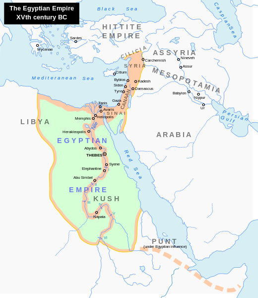
English: Map of the Middle East 1450 BC (by ArdadN)
Čeština: Největší územní rozsah starověkého Egypta, za vlády Thutmose I. |
| સ્રોત |
The original description page was here. All following user names refer to en.wikipedia.
|
| લેખક | ArdadN at અંગ્રેજી વિકિપીડિયા |
| અન્ય આવૃત્તિઓ |
[]
|


|
This SVG file contains embedded text that can be translated into your language, using any capable SVG editor, text editor or the SVG Translate tool. For more information see: About translating SVG files. |
પરવાના
| હું, આ રચનાઓ પ્રકાશન અધિકાર ધારક, આ રચનાને public domain પર પ્રકાશિત કરું છું. આ સમગ્ર વિશ્વમઆં કાર્યરત રહેશે. અમુક દેશોમાં કાયદેસર રીતે તે શક્ય નથી, જો તેમ હોય તો : કો કોઈને પણ કોઈપણ વપરાશ, કોઇ પણ શરત વગર, માટે આ રચના વાપરવાની છૂટ આપું છું સિવાયકે તે શરતો કાયદેસર જરૂરી હોય. |
ફાઇલનો ઇતિહાસ
તારીખ/સમય ઉપર ક્લિક કરવાથી તે સમયે ફાઇલ કેવી હતી તે જોવા મળશે.
| તારીખ/સમય | લઘુચિત્ર | પરિમાણો | સભ્ય | ટિપ્પણી | |
|---|---|---|---|---|---|
| વર્તમાન | ૦૩:૪૮, ૨૪ સપ્ટેમ્બર ૨૦૨૩ | | ૧,૩૦૦ × ૧,૫૦૦ (૨૫૭ KB) | Gaaryeelidmaan | Punt was associated with Myrrh trade, a product found in modern Puntland https://www.worldhistory.org/punt/ |
| ૧૦:૫૮, ૯ ઓક્ટોબર ૨૦૧૩ |  | ૧,૩૦૦ × ૧,૫૦૦ (૨૫૭ KB) | Lymantria | Reverted to version as of 00:24, 10 August 2008 | |
| ૨૧:૩૫, ૭ ઓક્ટોબર ૨૦૧૩ |  | ૧,૩૦૦ × ૧,૫૦૦ (૨૩૮ KB) | Emara | تعريب الخريطة | |
| ૦૫:૫૪, ૧૦ ઓગસ્ટ ૨૦૦૮ |  | ૧,૩૦૦ × ૧,૫૦૦ (૨૫૭ KB) | Leoboudv | {{Information |Description=Map of the Middle East 1450 BC |Source=The original description page is/was [http://en.wikipedia.org/w/index.php?title=Image%3AEgypt_1450_BC.svg here]. All following user names refer to en.wikipedia. * 2008-05-07 09:18 [[:en:Use |
ફાઇલનો વપરાશ
આ ફાઇલને કોઇ પાનાં વાપરતા નથી.
ફાઇલનો વ્યાપક ઉપયોગ
નીચેની બીજી વિકિઓ આ ફાઈલ વાપરે છે:
- ast.wikipedia.org પર વપરાશ
- azb.wikipedia.org પર વપરાશ
- az.wikipedia.org પર વપરાશ
- ba.wikipedia.org પર વપરાશ
- be.wikipedia.org પર વપરાશ
- bg.wikipedia.org પર વપરાશ
- bn.wikipedia.org પર વપરાશ
- ca.wikipedia.org પર વપરાશ
- cv.wikipedia.org પર વપરાશ
- de.wikipedia.org પર વપરાશ
- el.wikipedia.org પર વપરાશ
- en.wikipedia.org પર વપરાશ
- Timeline of Jerusalem
- Thutmose I
- The Bible Unearthed
- List of conflicts in Asia
- Middle Eastern empires
- List of conflicts in Egypt
- Land of Punt
- Transjordan (region)
- List of conflicts in Sudan
- List of conflicts in Libya
- User:Falcaorib
- Talk:The Exodus/Archive 18
- User:SomeGuyWhoRandomlyEdits/List of conflicts in the Near East
- eu.wikipedia.org પર વપરાશ
- fa.wikipedia.org પર વપરાશ
- gl.wikipedia.org પર વપરાશ
- hi.wikipedia.org પર વપરાશ
- hy.wikipedia.org પર વપરાશ
- hyw.wikipedia.org પર વપરાશ
- id.wikipedia.org પર વપરાશ
- id.wikibooks.org પર વપરાશ
- is.wikipedia.org પર વપરાશ
- it.wikipedia.org પર વપરાશ
- ja.wikipedia.org પર વપરાશ
આ ફાઇલના વધુ વૈશ્વિક વપરાશ જુઓ.