લખાણ પર જાઓ

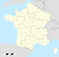
ચિત્ર:France location map-Departements 1997-2014.svg

Page contents not supported in other languages.
વિકિપીડિયામાંથી

મૂળભુત ફાઇલ (SVG ફાઇલ, માત્ર ૨,૦૦૦ × ૧,૯૨૨ પીક્સલ, ફાઇલનું કદ: ૭૮૩ KB)

આ ફાઇલ Wikimedia Commonsનો ભાગ છે અને શક્ય છે કે અન્ય પ્રકલ્પોમાં પણ વપરાઇ હોય. ત્યાંનાં મૂળ ફાઇલનાં વર્ણનનાં પાના પર આપેલું વર્ણન નીચે દર્શાવેલું છે.

સારાંશ:

Camera location૪૬° ૧૫′ ૦૦″ N, ૨° ૦૬′ ૦૦″ E Kartographer map based on OpenStreetMap.View this and other nearby images on: OpenStreetMapinfo


વર્ણન
English: Blank administrative map of France for geo-location purpose, with departements.
Approximate scale : 1:3,000,000
Français : Carte administrative vierge de la France destinée à la géolocalisation, avec départements.
Échelle approximative : 1:3 000 000

Equirectangular projection, WGS84 datum

  • Central meridian: 002° 06' E
  • True scale parallel: 46° 15' N

Geographic limits of the map :

  • West : 005° 48' W
  • East : 10° E
  • North : 51° 30' N
  • South : 41° N
તારીખ
સ્રોત

પોતાની રચના

લેખક Eric Gaba (Sting - fr:Sting)
પરવાનગી
(આ ફાઈલનો ફરી ઉપયોગ)
Attribution and Share-Alike required
અન્ય આવૃત્તિઓ
SVG genesis
InfoField
 
The SVG code is valid.
 
This map was created with Inkscape, or with something else.
 
This SVG map uses embedded text.

પરવાના

હું, આ કાર્યનો પ્રકાશનાધિકાર ધારક, તેને નીચેના પરવાનાઓ હેઠળ અહીં પ્રકાશીત કરૂં છું:
GNU head આ રચનાની નકલ કરવા, વિતરણ અને સુધારો કરવા માટે GNU Free Documentation License, આવૃત્તિ 1.2 કે અન્ય આગળની આવૃત્તિ Free Software Foundation હેઠળ પરવાનગી છે; જેમાં કોઈ Invariant Sections, no Front-Cover Texts, and no Back-Cover Texts નથી. આ પરવાનાની પ્રત GNU Free Documentation License વિભાગમાં છે.
w:en:Creative Commons
આરોપણ શેર- અલાઈક (બિન ભેદભાવ વહેંચણી)
This file is licensed under the Creative Commons Attribution-Share Alike 4.0 International, 3.0 Unported, 2.5 Generic, 2.0 Generic and 1.0 Generic license.
તમે મુક્ત છો:
  • વહેંચવા – નકલ કરવા, વિતરણ કરવા અને રચનાઓ મોકલવા
  • રીમિક્સ કરવા કે મઠારવા – રચના અપનાવવા
નીચેની શરત હેઠળ:
  • આરોપણ – તમારે આ રચનાનો ઉપયોગ કરવા માટે લેખક કે પ્રકાશન અધિકાર ધારકની યોગ્ય માહિતી, પરવાનગી ‍(‌લાયસન્સ)ની કડી અને તેમાં ફેરફાર કર્યો હોય તો તેનો ઉલ્લેખ કરવો જ પડશે. તમે આ સત્તા અનુસાર જ આ રચનાનો પ્રયોગ થવો જોઈએ, પણ તેઓ તમને અથવા તમારા ઉપયોગ સાથે સંમત થાય છે તે રીતે નહીં.
  • શેર- અલાઈક (બિન ભેદભાવ વહેંચણી) – તમે જો આ રચનાને બદલશો, તેમાં ફેરફાર કરશો અથવા તેના પર આધારિત કોઇ કાર્ય બનાવશો તો તમારે પરિણામી કાર્યને તે જ અથવા અનુરૂપ પરવાનગી હેઠળ જ પ્રકાશિત કરવું પડશે.
તમે તમારી પસંદગીનો પરવાનો પસંદ કરી શકો છો.

Captions

Add a one-line explanation of what this file represents

Items portrayed in this file

દર્શાવે છે

source of file અંગ્રેજી

original creation by uploader અંગ્રેજી

coordinates of the point of view અંગ્રેજી

46°15'0.000"N, 2°6'0.000"E

ફાઇલનો ઇતિહાસ

તારીખ/સમય ઉપર ક્લિક કરવાથી તે સમયે ફાઇલ કેવી હતી તે જોવા મળશે.

તારીખ/સમયલઘુચિત્રપરિમાણોસભ્યટિપ્પણી
વર્તમાન૧૯:૨૩, ૧૯ ઓક્ટોબર ૨૦૧૭૧૯:૨૩, ૧૯ ઓક્ટોબર ૨૦૧૭નું લઘુચિત્ર સંસ્કરણ૨,૦૦૦ × ૧,૯૨૨ (૭૮૩ KB)StingNo borders over the Lake of Constance
૧૮:૪૯, ૭ નવેમ્બર ૨૦૦૮૧૮:૪૯, ૭ નવેમ્બર ૨૦૦૮નું લઘુચિત્ર સંસ્કરણ૨,૦૦૦ × ૧,૯૨૨ (૭૮૪ KB)Sting+ boundary for Channel Islands
૨૨:૦૭, ૨૩ ઓગસ્ટ ૨૦૦૮૨૨:૦૭, ૨૩ ઓગસ્ટ ૨૦૦૮નું લઘુચિત્ર સંસ્કરણ૨,૦૦૦ × ૧,૯૨૨ (૭૮૨ KB)StingLarger strokes for boundaries
૨૩:૨૩, ૨૫ જુલાઇ ૨૦૦૮૨૩:૨૩, ૨૫ જુલાઇ ૨૦૦૮નું લઘુચિત્ર સંસ્કરણ૨,૦૦૦ × ૧,૯૨૨ (૭૮૨ KB)StingVariable scale
૨૦:૦૮, ૨૫ જુલાઇ ૨૦૦૮૨૦:૦૮, ૨૫ જુલાઇ ૨૦૦૮નું લઘુચિત્ર સંસ્કરણ૨,૦૦૦ × ૧,૯૨૨ (૭૮૫ KB)StingOther countries' color ; - border
૦૧:૫૬, ૫ જુલાઇ ૨૦૦૮૦૧:૫૬, ૫ જુલાઇ ૨૦૦૮નું લઘુચિત્ર સંસ્કરણ૨,૦૦૦ × ૧,૯૨૨ (૭૮૫ KB)Sting== Summary == {{Location|46|15|00|N|02|06|00|E|scale:10000000}} <br/> {{Information |Description={{en|Blank administrative map of France for geo-location purpose, with departements.<br/>Approximate scale : 1:3,000,000}} {{fr|Carte administr

આ ફાઇલને કોઇ પાનાં વાપરતા નથી.

ફાઇલનો વ્યાપક ઉપયોગ

મૅટાડેટા