
ચિત્ર:Great Lakes bathymetry map.png
મૂળભુત ફાઇલ (૧,૦૨૪ × ૭૩૧ પીક્સલ, ફાઇલનું કદ: ૧.૩૪ MB, MIME પ્રકાર: image/png)
સારાંશ:
| વર્ણન |
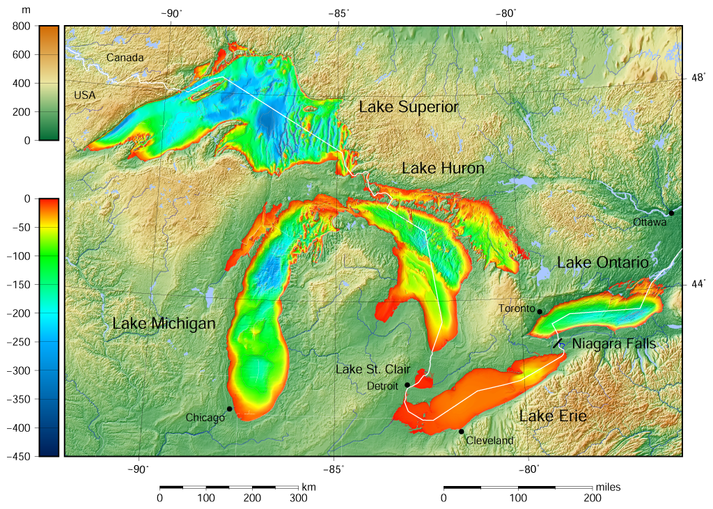
English: Great Lakes bathymetry and surrounding area shaded relief map. Lakes are contoured with interval 100 m. Lake Superior is incomplete. |
| તારીખ | |
| સ્રોત |
Own work using: the following Public Domain datasets (grids):
The color palette of the depth scale was made to be more or less similar to the color palettes used on the NGDC Great Lakes maps. |
| લેખક | Darekk2 using the Great Lakes Bathymetry and GLOBE tiles |
| અન્ય આવૃત્તિઓ |
|

પરવાના
Attribution (in addition to the author of this map):
The NGDC in it's copyright notice says:
As required by 17 U.S.C. 403, third parties producing copyrighted works consisting predominantly of the material produced by U.S. government agencies must provide notice with such work(s) identifying the U.S. Government material incorporated and stating that such material is not subject to copyright protection within the United States. (...)
(for credits see the Source section).
and Great Lakes Bathymetry and GLOBE
(see above and the Source section)
- તમે મુક્ત છો:
- વહેંચવા – નકલ કરવા, વિતરણ કરવા અને રચનાઓ મોકલવા
- રીમિક્સ કરવા કે મઠારવા – રચના અપનાવવા
- નીચેની શરત હેઠળ:
- આરોપણ – તમારે આ રચનાનો ઉપયોગ કરવા માટે લેખક કે પ્રકાશન અધિકાર ધારકની યોગ્ય માહિતી, પરવાનગી (લાયસન્સ)ની કડી અને તેમાં ફેરફાર કર્યો હોય તો તેનો ઉલ્લેખ કરવો જ પડશે. તમે આ સત્તા અનુસાર જ આ રચનાનો પ્રયોગ થવો જોઈએ, પણ તેઓ તમને અથવા તમારા ઉપયોગ સાથે સંમત થાય છે તે રીતે નહીં.
- શેર- અલાઈક (બિન ભેદભાવ વહેંચણી) – તમે જો આ રચનાને બદલશો, તેમાં ફેરફાર કરશો અથવા તેના પર આધારિત કોઇ કાર્ય બનાવશો તો તમારે પરિણામી કાર્યને તે જ અથવા અનુરૂપ પરવાનગી હેઠળ જ પ્રકાશિત કરવું પડશે.
ફાઇલનો ઇતિહાસ
તારીખ/સમય ઉપર ક્લિક કરવાથી તે સમયે ફાઇલ કેવી હતી તે જોવા મળશે.
| તારીખ/સમય | લઘુચિત્ર | પરિમાણો | સભ્ય | ટિપ્પણી | |
|---|---|---|---|---|---|
| વર્તમાન | ૨૧:૧૬, ૯ મે ૨૦૧૫ | | ૧,૦૨૪ × ૭૩૧ (૧.૩૪ MB) | Darekk2 | more accurate shorelines, the lakes tiles better assembled, added Canada, USA and Lake St. Clair labels, moved Detroit label, Michigan Lake - retouched western part of Green Bay |
| ૧૫:૩૩, ૨૫ માર્ચ ૨૦૧૫ |  | ૧,૦૨૪ × ૭૩૧ (૧.૩૪ MB) | Darekk2 | changed illumination for shaded relief | |
| ૦૬:૫૯, ૨૫ માર્ચ ૨૦૧૫ |  | ૧,૦૨૪ × ૭૩૧ (૧.૩૩ MB) | Darekk2 | changed palette a little | |
| ૦૧:૫૧, ૨૫ માર્ચ ૨૦૧૫ |  | ૧,૦૨૪ × ૭૩૧ (૧.૬૧ MB) | Darekk2 | User created page with UploadWizard |
ફાઇલનો વપરાશ
આ ફાઇલને કોઇ પાનાં વાપરતા નથી.
ફાઇલનો વ્યાપક ઉપયોગ
નીચેની બીજી વિકિઓ આ ફાઈલ વાપરે છે:
- ar.wikipedia.org પર વપરાશ
- en.wikipedia.org પર વપરાશ
- fi.wikipedia.org પર વપરાશ
- ja.wikipedia.org પર વપરાશ
- nl.wikipedia.org પર વપરાશ
- sr.wikipedia.org પર વપરાશ
- tt.wikipedia.org પર વપરાશ
- uk.wikipedia.org પર વપરાશ
- vep.wikipedia.org પર વપરાશ
- www.wikidata.org પર વપરાશ
- zh-yue.wikipedia.org પર વપરાશ