
ચિત્ર:IslamicConquestsIroon.png
આ પૂર્વાવલોકનનું કદ: ૬૭૫ × ૫૯૯ પિક્સેલ. અન્ય આવર્તનો: ૨૭૦ × ૨૪૦ પિક્સેલ | ૫૪૧ × ૪૮૦ પિક્સેલ | ૧,૦૦૬ × ૮૯૩ પિક્સેલ.
મૂળભુત ફાઇલ (૧,૦૦૬ × ૮૯૩ પીક્સલ, ફાઇલનું કદ: ૧૦૫ KB, MIME પ્રકાર: image/png)

|
This historical map image could be re-created using vector graphics as an SVG file. This has several advantages; see Commons:Media for cleanup for more information. If an SVG form of this image is available, please upload it and afterwards replace this template with
{{vector version available|new image name}}.
It is recommended to name the SVG file “IslamicConquestsIroon.svg”—then the template Vector version available (or Vva) does not need the new image name parameter. |
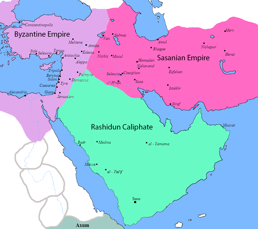
| વર્ણન |
English: Map of the Sassanid, Byzantine and Muslim borders. |
| સ્રોત | File:Pre_Islamic_Arabia.PNG |
| લેખક | Javierfv1212 and edited by HistoryofIran. |
| અન્ય આવૃત્તિઓ |
[]
|


This file is in the public domain because File:Pre_Islamic_Arabia.PNG
|
ફાઇલનો ઇતિહાસ
તારીખ/સમય ઉપર ક્લિક કરવાથી તે સમયે ફાઇલ કેવી હતી તે જોવા મળશે.
| તારીખ/સમય | લઘુચિત્ર | પરિમાણો | સભ્ય | ટિપ્પણી | |
|---|---|---|---|---|---|
| વર્તમાન | ૧૫:૪૩, ૧૮ સપ્ટેમ્બર ૨૦૧૯ | | ૧,૦૦૬ × ૮૯૩ (૧૦૫ KB) | HistoryofIran | rv, thats not how it works |
| ૧૦:૨૧, ૧૮ સપ્ટેમ્બર ૨૦૧૯ |  | ૧,૦૦૬ × ૮૯૩ (૧૦૩ KB) | Сахалин21 | Under Hormizd IV, Persia won the Perso-Turkic War and conquered Samarqand and the Transoxiania. | |
| ૧૦:૨૦, ૧૮ સપ્ટેમ્બર ૨૦૧૯ |  | ૧,૦૦૬ × ૮૯૩ (૧૦૫ KB) | Сахалин21 | Reverted to version as of 01:15, 3 August 2019 (UTC) | |
| ૧૦:૧૫, ૧૮ સપ્ટેમ્બર ૨૦૧૯ |  | ૧,૦૦૬ × ૮૯૩ (૧૦૩ KB) | Сахалин21 | Reverted to version as of 19:13, 14 November 2017 (UTC) | |
| ૦૬:૪૫, ૩ ઓગસ્ટ ૨૦૧૯ |  | ૧,૦૦૬ × ૮૯૩ (૧૦૫ KB) | HistoryofIran | rv, no, they weren't at all | |
| ૦૦:૦૮, ૨ ઓગસ્ટ ૨૦૧૯ |  | ૧,૦૦૬ × ૮૯૩ (૧૦૫ KB) | Mehrdad 12 | The eastern borders were conquered during the reign of Queen Purandokht. | |
| ૦૦:૦૪, ૨ ઓગસ્ટ ૨૦૧૯ |  | ૧,૦૦૬ × ૮૯૩ (૧૦૬ KB) | Mehrdad 12 | I corrected the eastern borders. The Great Khorasan and Khwarizmi Desert were considered imperial. | |
| ૦૮:૨૧, ૧૨ ફેબ્રુઆરી ૨૦૧૯ |  | ૧,૦૦૬ × ૮૯૩ (૧૦૫ KB) | HistoryofIran | Made the map somewhat more accurate, probably more to come. | |
| ૦૦:૪૩, ૧૫ નવેમ્બર ૨૦૧૭ |  | ૧,૦૦૬ × ૮૯૩ (૧૦૩ KB) | HistoryofIran | rv, the Sasanian Empire didnt control that much | |
| ૧૬:૩૨, ૧૨ નવેમ્બર ૨૦૧૭ |  | ૧,૦૦૬ × ૮૯૩ (૧૨૮ KB) | Mehrdad 12 | {{NAMESPACE}}{{PAGENAME}}[[]][[:File:]]]] |
ફાઇલનો વપરાશ
આ ફાઇલને કોઇ પાનાં વાપરતા નથી.
ફાઇલનો વ્યાપક ઉપયોગ
નીચેની બીજી વિકિઓ આ ફાઈલ વાપરે છે:
- bg.wikipedia.org પર વપરાશ
- bn.wikipedia.org પર વપરાશ
- bn.wikiquote.org પર વપરાશ
- bs.wikipedia.org પર વપરાશ
- cs.wikipedia.org પર વપરાશ
- da.wikipedia.org પર વપરાશ
- de.wikipedia.org પર વપરાશ
- diq.wikipedia.org પર વપરાશ
- en.wikipedia.org પર વપરાશ
- fa.wikipedia.org પર વપરાશ
- fa.wikibooks.org પર વપરાશ
- fi.wikipedia.org પર વપરાશ
- fr.wikipedia.org પર વપરાશ
- he.wikipedia.org પર વપરાશ
- hr.wikipedia.org પર વપરાશ
- hy.wikipedia.org પર વપરાશ
- hyw.wikipedia.org પર વપરાશ
- ka.wikipedia.org પર વપરાશ
- ko.wikipedia.org પર વપરાશ
- ru.wikipedia.org પર વપરાશ
- sr.wikipedia.org પર વપરાશ
- sv.wikipedia.org પર વપરાશ
- ta.wikipedia.org પર વપરાશ
- th.wikipedia.org પર વપરાશ
- tr.wikipedia.org પર વપરાશ
- uk.wikipedia.org પર વપરાશ
- zh.wikipedia.org પર વપરાશ