
ચિત્ર:Leonhard Euler World Map AD1760.jpg

આ પૂર્વાવલોકનનું કદ: ૬૯૬ × ૫૯૯ પિક્સેલ. અન્ય આવર્તનો: ૨૭૯ × ૨૪૦ પિક્સેલ | ૫૫૭ × ૪૮૦ પિક્સેલ | ૮૯૨ × ૭૬૮ પિક્સેલ | ૧,૧૮૯ × ૧,૦૨૪ પિક્સેલ | ૨,૩૭૮ × ૨,૦૪૮ પિક્સેલ | ૨,૬૧૫ × ૨,૨૫૨ પિક્સેલ.
મૂળભુત ફાઇલ (૨,૬૧૫ × ૨,૨૫૨ પીક્સલ, ફાઇલનું કદ: ૨.૭૯ MB, MIME પ્રકાર: image/jpeg)
સારાંશ:
| વર્ણન |
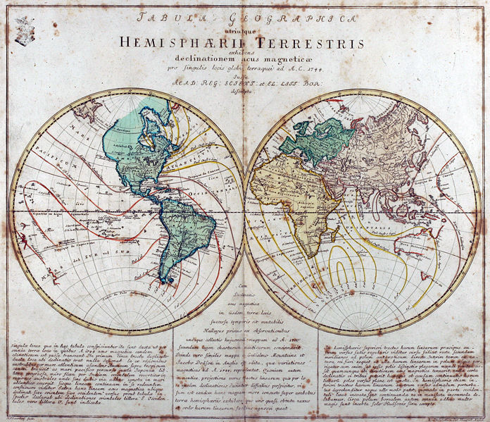
Tabula Geographica utriusque Hemisphaerii Terrestris exhibens declinationem acus magneticae pro singulis locis globi terraquei ad A. C. 1744. Iussu Acad: Reg: Scient: et El: Litt: Bor: descripta. Deutsch: Kupferstich-Weltkarte von Leonhard Euler aus seinem Schulatlas Geographischer Atlas bestehend in 44 Land-Charten erstmals 1753 in Berlin erschienen
English: Engraved world map (including magnetic declination lines) by Leonhard Euler from his school atlas “Geographischer Atlas bestehend in 44 Land-Charten” first published 1753 in Berlin |
||||||||||||||||||||||||||
| તારીખ | |||||||||||||||||||||||||||
| સ્રોત | Antique-World: Antique World Map by Leonhard Euler | ||||||||||||||||||||||||||
| લેખક |
|
||||||||||||||||||||||||||
| પરવાનગી (આ ફાઈલનો ફરી ઉપયોગ) |
Own work | ||||||||||||||||||||||||||

પરવાના
|
This work is in the public domain in its country of origin and other countries and areas where the copyright term is the author's life plus 100 years or fewer. This work is in the public domain in the United States because it was published (or registered with the U.S. Copyright Office) before January 1, 1929. | |
| પ્રકાશન કાયદા હેઠળ અને તેને મળતા આવતાં આ ફાઈલ ને મુક્ત ગણાઈ છે | |
ફાઇલનો ઇતિહાસ
તારીખ/સમય ઉપર ક્લિક કરવાથી તે સમયે ફાઇલ કેવી હતી તે જોવા મળશે.
| તારીખ/સમય | લઘુચિત્ર | પરિમાણો | સભ્ય | ટિપ્પણી | |
|---|---|---|---|---|---|
| વર્તમાન | ૦૭:૩૮, ૨૬ એપ્રિલ ૨૦૦૮ | | ૨,૬૧૫ × ૨,૨૫૨ (૨.૭૯ MB) | Ray007 | == Summary == {{Information |Description={{de|Kupferstich Weltkarte von Leonahrd Euler aus seinem Schulatlas "Geographischer Atlas bestehend in 44 Land-Charten" erstmals 1753 in Berlin erschienen}} {{en|Engraved world map by Leonahrd Euler from his school |
| ૦૭:૦૯, ૨૬ એપ્રિલ ૨૦૦૮ |  | ૩,૫૦૪ × ૨,૩૩૬ (૪.૮૮ MB) | Ray007 | {{Information |Description={{de|Kupferstich Weltkarte von Leonahrd Euler aus seinem Schulatlas "Geographischer Atlas bestehend in 44 Land-Charten" erstmals 1753 in Berlin erschienen}} {{en|Engraved world map by Leonahrd Euler from his school atlas "Geogra |
ફાઇલનો વપરાશ
આ ફાઇલને કોઇ પાનાં વાપરતા નથી.
ફાઇલનો વ્યાપક ઉપયોગ
નીચેની બીજી વિકિઓ આ ફાઈલ વાપરે છે:
- ar.wikipedia.org પર વપરાશ
- ast.wikipedia.org પર વપરાશ
- be.wikipedia.org પર વપરાશ
- br.wikipedia.org પર વપરાશ
- de.wikipedia.org પર વપરાશ
- en.wikipedia.org પર વપરાશ
- eo.wikiquote.org પર વપરાશ
- eu.wikipedia.org પર વપરાશ
- fr.wikipedia.org પર વપરાશ
- ia.wikipedia.org પર વપરાશ
- ko.wikipedia.org પર વપરાશ
- ru.wikipedia.org પર વપરાશ
- sh.wikipedia.org પર વપરાશ
- sr.wikipedia.org પર વપરાશ
- tr.wikipedia.org પર વપરાશ
- www.wikidata.org પર વપરાશ