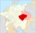
ચિત્ર:Locator Bohemia within the Holy Roman Empire (1618).svg
Appearance

Size of this PNG preview of this SVG file: ૬૫૮ × ૬૦૦ પિક્સેલ. અન્ય આવર્તનો: ૨૬૩ × ૨૪૦ પિક્સેલ | ૫૨૭ × ૪૮૦ પિક્સેલ | ૮૪૩ × ૭૬૮ પિક્સેલ | ૧,૧૨૩ × ૧,૦૨૪ પિક્સેલ | ૨,૨૪૭ × ૨,૦૪૮ પિક્સેલ | ૨,૭૬૯ × ૨,૫૨૪ પિક્સેલ.
મૂળભુત ફાઇલ (SVG ફાઇલ, માત્ર ૨,૭૬૯ × ૨,૫૨૪ પીક્સલ, ફાઇલનું કદ: ૧,૦૨૧ KB)
ફાઇલનો ઇતિહાસ
તારીખ/સમય ઉપર ક્લિક કરવાથી તે સમયે ફાઇલ કેવી હતી તે જોવા મળશે.
| તારીખ/સમય | લઘુચિત્ર | પરિમાણો | સભ્ય | ટિપ્પણી | |
|---|---|---|---|---|---|
| વર્તમાન | ૦૩:૦૨, ૧૪ મે ૨૦૧૯ |  | ૨,૭૬૯ × ૨,૫૨૪ (૧,૦૨૧ KB) | Ernio48 | Not a separate Land of the Bohemian Crown. There were 5 Lands. Eger was part of the Kingdom of Bohemia. Virtually every historical map includes it as its part. |
| ૦૫:૫૩, ૧૩ મે ૨૦૧૯ |  | ૨,૭૬૯ × ૨,૫૨૪ (૧,૦૨૩ KB) | David Beneš | Restored. The fact is stated in every WP article about Egerland/Chebsko, cf. the sources there. | |
| ૨૧:૨૩, ૧૧ મે ૨૦૧૯ |  | ૨,૭૬૯ × ૨,૫૨૪ (૧,૦૨૧ KB) | Ernio48 | Reverted to version as of 09:56, 30 April 2016 (UTC) Needs proof. | |
| ૧૯:૨૯, ૨૩ જૂન ૨૦૧૬ |  | ૨,૭૬૯ × ૨,૫૨૪ (૧,૦૨૩ KB) | David Beneš | Not the Land of Eger (a separate unit by then). | |
| ૧૫:૨૬, ૩૦ એપ્રિલ ૨૦૧૬ |  | ૨,૭૬૯ × ૨,૫૨૪ (૧,૦૨૧ KB) | David Beneš | + the County of Glaz. | |
| ૧૨:૪૩, ૨૫ એપ્રિલ ૨૦૧૬ |  | ૨,૭૬૯ × ૨,૫૨૪ (૧,૦૨૪ KB) | Der Golem | +Lands of the Bohemian Crown | |
| ૦૬:૧૮, ૨૮ જાન્યુઆરી ૨૦૧૫ |  | ૨,૭૬૯ × ૨,૫૨૪ (૧,૦૨૪ KB) | Sir Iain | Corrected Bohemian border | |
| ૧૯:૨૮, ૨૭ જાન્યુઆરી ૨૦૧૫ |  | ૨,૭૬૯ × ૨,૫૨૪ (૧,૦૧૪ KB) | Sir Iain | Redone Schleswig-Holstein | |
| ૦૬:૨૫, ૫ જાન્યુઆરી ૨૦૧૫ |  | ૨,૭૬૯ × ૨,૫૨૪ (૯૯૪ KB) | Sir Iain | Savoy shown as core territory of the HRR | |
| ૦૧:૫૮, ૨૪ ડિસેમ્બર ૨૦૧૪ |  | ૨,૭૬૯ × ૨,૫૨૪ (૯૯૪ KB) | Sir Iain | Removed the Imperial border between Germany and the Netherlands |
ફાઇલનો વપરાશ
આ ફાઇલને કોઇ પાનાં વાપરતા નથી.
ફાઇલનો વ્યાપક ઉપયોગ
નીચેની બીજી વિકિઓ આ ફાઈલ વાપરે છે:
- ar.wikipedia.org પર વપરાશ
- arz.wikipedia.org પર વપરાશ
- ast.wikipedia.org પર વપરાશ
- ba.wikipedia.org પર વપરાશ
- ca.wikipedia.org પર વપરાશ
- cs.wikipedia.org પર વપરાશ
- da.wikipedia.org પર વપરાશ
- de.wikipedia.org પર વપરાશ
- de.wikibooks.org પર વપરાશ
- el.wikipedia.org પર વપરાશ
- en.wikipedia.org પર વપરાશ
- eo.wikipedia.org પર વપરાશ
- es.wikipedia.org પર વપરાશ
- et.wikipedia.org પર વપરાશ
- fa.wikipedia.org પર વપરાશ
- fi.wikipedia.org પર વપરાશ
- frr.wikipedia.org પર વપરાશ
- fr.wikipedia.org પર વપરાશ
- ga.wikipedia.org પર વપરાશ
- gl.wikipedia.org પર વપરાશ
- hr.wikipedia.org પર વપરાશ
- hu.wikipedia.org પર વપરાશ
- id.wikipedia.org પર વપરાશ
- it.wikipedia.org પર વપરાશ
- ja.wikipedia.org પર વપરાશ
- ko.wikipedia.org પર વપરાશ
- ku.wikipedia.org પર વપરાશ
- la.wikipedia.org પર વપરાશ
- lt.wikipedia.org પર વપરાશ
- lv.wikipedia.org પર વપરાશ
- mk.wikipedia.org પર વપરાશ
- nl.wikipedia.org પર વપરાશ
- no.wikipedia.org પર વપરાશ
- pl.wikipedia.org પર વપરાશ
આ ફાઇલના વધુ વૈશ્વિક વપરાશ જુઓ.
