
ચિત્ર:Map of Bengal.svg

Size of this PNG preview of this SVG file: ૬૫૬ × ૫૯૯ પિક્સેલ. અન્ય આવર્તનો: ૨૬૩ × ૨૪૦ પિક્સેલ | ૫૨૬ × ૪૮૦ પિક્સેલ | ૮૪૧ × ૭૬૮ પિક્સેલ | ૧,૧૨૧ × ૧,૦૨૪ પિક્સેલ | ૨,૨૪૨ × ૨,૦૪૮ પિક્સેલ | ૧,૮૩૫ × ૧,૬૭૬ પિક્સેલ.
મૂળભુત ફાઇલ (SVG ફાઇલ, માત્ર ૧,૮૩૫ × ૧,૬૭૬ પીક્સલ, ફાઇલનું કદ: ૧.૩૨ MB)
સારાંશ:
| વર્ણન |
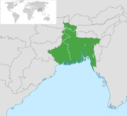
English: Map of Bengal. The region is today divided between East Bengal (Bangladesh) and West Bengal. Also showing the state of Tripura and the three districts of Cachar, Hailakandi and Karimganj; part of Barak Valley in Assam, India. Svenska: Karta av Bengal, delad mellan östra och västra. Staten Tripura och distrikten Hailakandi och Karimganj i södra Assam visas också. বাংলা: বাংলার মানচিত্র, পূর্ব ও পশ্চিমের মধ্যে বিভক্ত করা। মানচিত্রে চিহ্নিত রয়েছে বাংলাদেশের পূর্বে অবস্থিত বাংলাভাষী ভারতীয় রাজ্য ত্রিপুরা সহ আসাম রাজ্যের বরাক উপত্যকার তিনটি জেলা কাছাড়, হাইলাকান্দি এবং করিমগঞ্জ। |
| તારીખ | |
| સ્રોત |
|
| લેખક | Goran tek-en |
| SVG genesis |

.svg)

પરવાના
This file is licensed under the Creative Commons Attribution-Share Alike 4.0 International license.
આરોપણ: Goran tek-en
- તમે મુક્ત છો:
- વહેંચવા – નકલ કરવા, વિતરણ કરવા અને રચનાઓ મોકલવા
- રીમિક્સ કરવા કે મઠારવા – રચના અપનાવવા
- નીચેની શરત હેઠળ:
- આરોપણ – તમારે આ રચનાનો ઉપયોગ કરવા માટે લેખક કે પ્રકાશન અધિકાર ધારકની યોગ્ય માહિતી, પરવાનગી (લાયસન્સ)ની કડી અને તેમાં ફેરફાર કર્યો હોય તો તેનો ઉલ્લેખ કરવો જ પડશે. તમે આ સત્તા અનુસાર જ આ રચનાનો પ્રયોગ થવો જોઈએ, પણ તેઓ તમને અથવા તમારા ઉપયોગ સાથે સંમત થાય છે તે રીતે નહીં.
- શેર- અલાઈક (બિન ભેદભાવ વહેંચણી) – તમે જો આ રચનાને બદલશો, તેમાં ફેરફાર કરશો અથવા તેના પર આધારિત કોઇ કાર્ય બનાવશો તો તમારે પરિણામી કાર્યને તે જ અથવા અનુરૂપ પરવાનગી હેઠળ જ પ્રકાશિત કરવું પડશે.
ફાઇલનો ઇતિહાસ
તારીખ/સમય ઉપર ક્લિક કરવાથી તે સમયે ફાઇલ કેવી હતી તે જોવા મળશે.
| તારીખ/સમય | લઘુચિત્ર | પરિમાણો | સભ્ય | ટિપ્પણી | |
|---|---|---|---|---|---|
| વર્તમાન | ૧૫:૩૩, ૨ નવેમ્બર ૨૦૨૨ | | ૧,૮૩૫ × ૧,૬૭૬ (૧.૩૨ MB) | MS Sakib | Reverted to version as of 18:02, 10 March 2022 (UTC) (tripura and barak area are included in bengal region!) |
| ૧૦:૫૮, ૪ ઓક્ટોબર ૨૦૨૨ |  | ૧,૮૩૫ × ૧,૬૭૬ (૧.૩૧ MB) | Msasag | Reverted to version as of 16:42, 4 October 2016 (UTC) | |
| ૨૩:૩૨, ૧૦ માર્ચ ૨૦૨૨ |  | ૧,૮૩૫ × ૧,૬૭૬ (૧.૩૨ MB) | MS Sakib | Barak Valley area fixed | |
| ૧૬:૫૫, ૧૨ નવેમ્બર ૨૦૧૭ |  | ૧,૮૩૫ × ૧,૬૭૬ (૧.૩૨ MB) | Mouryan | =={{int:filedesc}}== {{Information |description={{en|1=Map of Bengal, divided between east and west.}}{{sv|1=Karta av Bengal, delad mellan östra och västra.}}{{bn|1=বাংলার মানচিত্র, পূর্ব ও পশ্চিম... | |
| ૨૨:૧૨, ૪ ઓક્ટોબર ૨૦૧૬ |  | ૧,૮૩૫ × ૧,૬૭૬ (૧.૩૧ MB) | BurritoBazooka | fix minimap bg turning up transparent in thumbnail? | |
| ૨૨:૧૦, ૪ ઓક્ટોબર ૨૦૧૬ |  | ૧,૮૩૫ × ૧,૬૭૬ (૧.૩૧ MB) | BurritoBazooka | paste File:BlankMap-World gray.svg in again for minimap, this time with Alaska and Lesotho. | |
| ૨૨:૪૩, ૧ ડિસેમ્બર ૨૦૧૩ |  | ૧,૮૩૫ × ૧,૬૭૬ (૧.૧૯ MB) | Goran tek-en | Enlarged map ~~~~ | |
| ૨૩:૨૩, ૩૦ નવેમ્બર ૨૦૧૩ |  | ૧,૮૩૬ × ૧,૬૭૯ (૧.૨ MB) | Goran tek-en | User created page with UploadWizard |
ફાઇલનો વપરાશ
આ ફાઇલને કોઇ પાનાં વાપરતા નથી.
ફાઇલનો વ્યાપક ઉપયોગ
નીચેની બીજી વિકિઓ આ ફાઈલ વાપરે છે:
- af.wikipedia.org પર વપરાશ
- ang.wikipedia.org પર વપરાશ
- ar.wikipedia.org પર વપરાશ
- ast.wikipedia.org પર વપરાશ
- as.wikipedia.org પર વપરાશ
- azb.wikipedia.org પર વપરાશ
- az.wikipedia.org પર વપરાશ
- az.wikiquote.org પર વપરાશ
- be.wikipedia.org પર વપરાશ
- bg.wikipedia.org પર વપરાશ
- bn.wikipedia.org પર વપરાશ
- টেমপ্লেট:ব্যবহারকারী/বাঙালি
- বঙ্গ
- ব্যবহারকারী:Snthakur
- ব্যবহারকারী:Wiki naogaon
- বঙ্গভঙ্গ (১৯৪৭)
- ব্যবহারকারী:Ali Haidar Khan
- ব্যবহারকারী:Tanveer.nonstop
- ব্যবহারকারী:Faysal
- ব্যবহারকারী:Jonoikobangali
- ব্যবহারকারী:Jayantanth/Userboxes
- ব্যবহারকারী:Yahia.barie
- ব্যবহারকারী:Tarunno
- ব্যবহারকারী:Ikfaisal
- প্রবেশদ্বার:বাংলাদেশ
- ব্যবহারকারী:Pasaban
- ব্যবহারকারী:Wildscop
- ব্যবহারকারী:Rezowan
- ব্যবহারকারী:ছেঁড়াবাকল
- ব্যবহারকারী:DesiNinja
- ব্যবহারকারী:Hemayet
- ব্যবহারকারী:Hemayetfaridpur
- ব্যবহারকারী:004satcho
- ব্যবহারকারী:Babaidmun
- ব্যবহারকারী:Bodhisattwa
- ব্যবহারকারী:Akramul Hoque Samim
- ব্যবহারকারী:শাহনেওয়াজ শুভ
- ব্যবহারকারী:Muhammad Tasbir Iftekhar
- ব্যবহারকারী:Mohd. Toukir Hamid
- ব্যবহারকারী:ইউক্লিড রনি
- ব্যবহারকারী:Sukanta Sarkar
- ব্যবহারকারী:Ashiq Shawon
- ব্যবহারকারী:Asaduzzamana
- ব্যবহারকারী:Akash Islam
- ব্যবহারকারী:Sabarni sarker
- ব্যবহারকারী:হাসান মাহমুদ
- ব্যবহারকারী:Md.Faysal Alam Riyad
આ ફાઇલના વધુ વૈશ્વિક વપરાશ જુઓ.