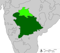
ચિત્ર:Map of the Hyderabad princely state (1909).svg
Appearance

Size of this PNG preview of this SVG file: ૬૮૩ × ૫૯૯ પિક્સેલ. અન્ય આવર્તનો: ૨૭૪ × ૨૪૦ પિક્સેલ | ૫૪૭ × ૪૮૦ પિક્સેલ | ૮૭૫ × ૭૬૮ પિક્સેલ | ૧,૧૬૭ × ૧,૦૨૪ પિક્સેલ | ૨,૩૩૪ × ૨,૦૪૮ પિક્સેલ.
મૂળભુત ફાઇલ (SVG ફાઇલ, માત્ર ૮૦૦ × ૭૦૨ પીક્સલ, ફાઇલનું કદ: ૨૭ KB)
ફાઇલનો ઇતિહાસ
તારીખ/સમય ઉપર ક્લિક કરવાથી તે સમયે ફાઇલ કેવી હતી તે જોવા મળશે.
| તારીખ/સમય | લઘુચિત્ર | પરિમાણો | સભ્ય | ટિપ્પણી | |
|---|---|---|---|---|---|
| વર્તમાન | ૧૭:૪૮, ૨૫ એપ્રિલ ૨૦૧૨ |  | ૮૦૦ × ૭૦૨ (૨૭ KB) | Jkan997 | removed labels |
| ૧૪:૨૨, ૨૫ એપ્રિલ ૨૦૧૨ |  | ૮૦૦ × ૭૦૨ (૨૮ KB) | Jkan997 | {{Information |Description ={{en|1=Map of Indian state of Hyderabad in 1909 Legend: *<span style="color:#646464">━━━</span>Princely states borders *<span style="color:#EEEEEE">━━━</span>Princely states territories *<span style="color:#... |
ફાઇલનો વપરાશ
આ ફાઇલને કોઇ પાનાં વાપરતા નથી.
ફાઇલનો વ્યાપક ઉપયોગ
નીચેની બીજી વિકિઓ આ ફાઈલ વાપરે છે:
- ar.wikipedia.org પર વપરાશ
- az.wikipedia.org પર વપરાશ
- bn.wikipedia.org પર વપરાશ
- cs.wikipedia.org પર વપરાશ
- da.wikipedia.org પર વપરાશ
- en.wikipedia.org પર વપરાશ
- es.wikipedia.org પર વપરાશ
- eu.wikipedia.org પર વપરાશ
- fa.wikipedia.org પર વપરાશ
- fi.wikipedia.org પર વપરાશ
- he.wikipedia.org પર વપરાશ
- hu.wikipedia.org પર વપરાશ
- hy.wikipedia.org પર વપરાશ
- id.wikipedia.org પર વપરાશ
- io.wikipedia.org પર વપરાશ
- it.wikipedia.org પર વપરાશ
- ja.wikipedia.org પર વપરાશ
- kn.wikipedia.org પર વપરાશ
- ko.wikipedia.org પર વપરાશ
- ml.wikipedia.org પર વપરાશ
- ms.wikipedia.org પર વપરાશ
- my.wikipedia.org પર વપરાશ
- pnb.wikipedia.org પર વપરાશ
- pt.wikipedia.org પર વપરાશ
- ru.wikipedia.org પર વપરાશ
- sd.wikipedia.org પર વપરાશ
- simple.wikipedia.org પર વપરાશ
- sv.wikipedia.org પર વપરાશ
- ta.wikipedia.org પર વપરાશ
- te.wikipedia.org પર વપરાશ
- tg.wikipedia.org પર વપરાશ
- th.wikipedia.org પર વપરાશ
- tr.wikipedia.org પર વપરાશ
- uk.wikipedia.org પર વપરાશ
આ ફાઇલના વધુ વૈશ્વિક વપરાશ જુઓ.


