
ચિત્ર:Marine protected areas detailed map.jpg
આ પૂર્વાવલોકનનું કદ: ૮૦૦ × ૪૮૬ પિક્સેલ. અન્ય આવર્તનો: ૩૨૦ × ૧૯૪ પિક્સેલ | ૬૪૦ × ૩૮૯ પિક્સેલ | ૧,૦૨૪ × ૬૨૨ પિક્સેલ | ૧,૨૮૦ × ૭૭૭ પિક્સેલ | ૨,૫૬૦ × ૧,૫૫૪ પિક્સેલ | ૪,૨૦૦ × ૨,૫૫૦ પિક્સેલ.
મૂળભુત ફાઇલ (૪,૨૦૦ × ૨,૫૫૦ પીક્સલ, ફાઇલનું કદ: ૧.૧૮ MB, MIME પ્રકાર: image/jpeg)
સારાંશ:
| વર્ણન |
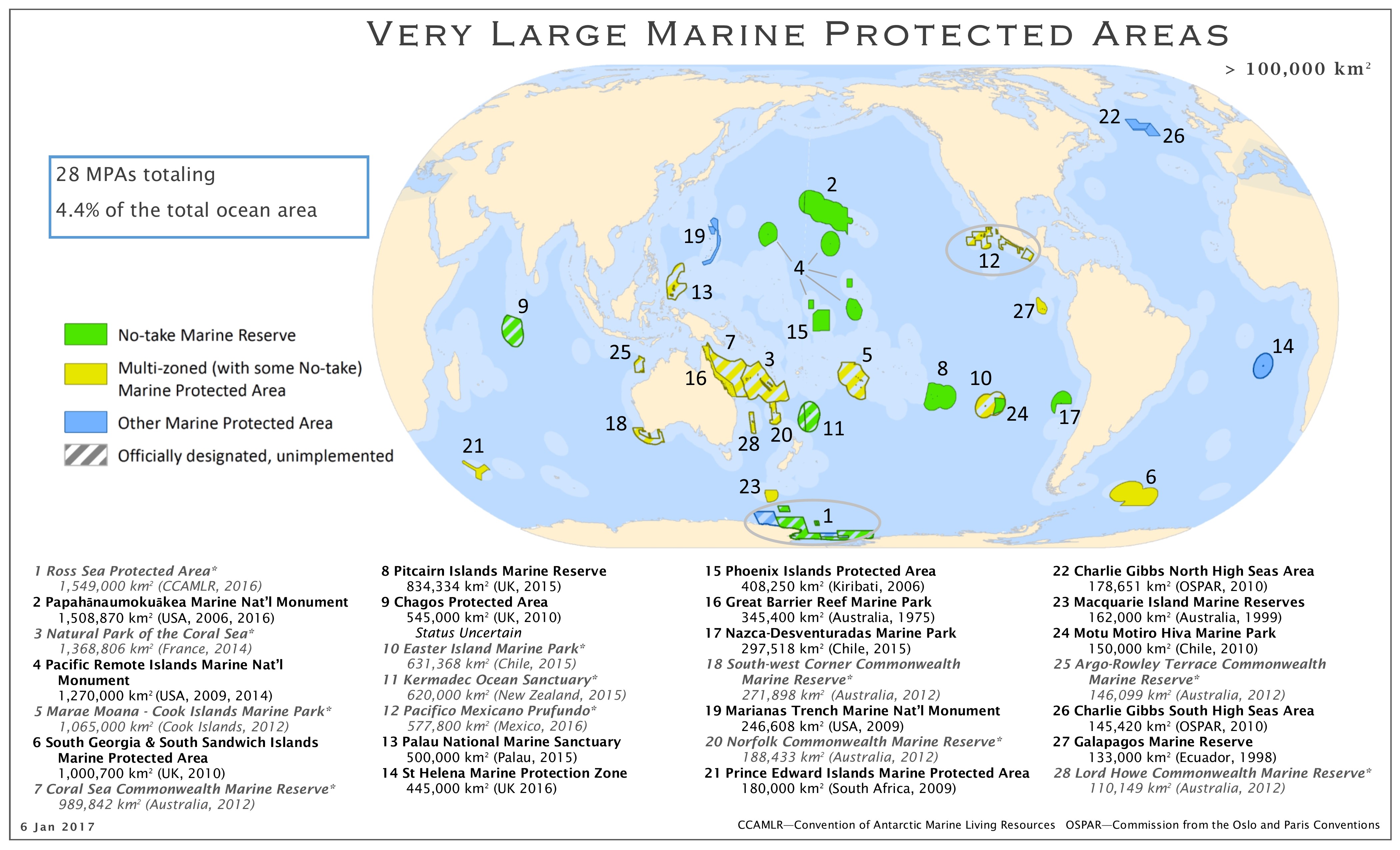
English: Map of the marine protected areas as of 01/2017 |
| તારીખ | |
| સ્રોત | http://imperative-mooc.magnetised.net/monitoring-the-oceans-from-space/week-5-oceans-and-us/topic-5a-policy/marine-protected-areas-detailed-map |
| લેખક | MPAtlas.org / Marine Conservation Institute |
| પરવાનગી (આ ફાઈલનો ફરી ઉપયોગ) |
પરવાના
This file is licensed under the Creative Commons Attribution-Share Alike 4.0 International license.
- તમે મુક્ત છો:
- વહેંચવા – નકલ કરવા, વિતરણ કરવા અને રચનાઓ મોકલવા
- રીમિક્સ કરવા કે મઠારવા – રચના અપનાવવા
- નીચેની શરત હેઠળ:
- આરોપણ – તમારે આ રચનાનો ઉપયોગ કરવા માટે લેખક કે પ્રકાશન અધિકાર ધારકની યોગ્ય માહિતી, પરવાનગી (લાયસન્સ)ની કડી અને તેમાં ફેરફાર કર્યો હોય તો તેનો ઉલ્લેખ કરવો જ પડશે. તમે આ સત્તા અનુસાર જ આ રચનાનો પ્રયોગ થવો જોઈએ, પણ તેઓ તમને અથવા તમારા ઉપયોગ સાથે સંમત થાય છે તે રીતે નહીં.
- શેર- અલાઈક (બિન ભેદભાવ વહેંચણી) – તમે જો આ રચનાને બદલશો, તેમાં ફેરફાર કરશો અથવા તેના પર આધારિત કોઇ કાર્ય બનાવશો તો તમારે પરિણામી કાર્યને તે જ અથવા અનુરૂપ પરવાનગી હેઠળ જ પ્રકાશિત કરવું પડશે.
ફાઇલનો ઇતિહાસ
તારીખ/સમય ઉપર ક્લિક કરવાથી તે સમયે ફાઇલ કેવી હતી તે જોવા મળશે.
| તારીખ/સમય | લઘુચિત્ર | પરિમાણો | સભ્ય | ટિપ્પણી | |
|---|---|---|---|---|---|
| વર્તમાન | ૧૧:૫૨, ૧૨ જાન્યુઆરી ૨૦૧૭ | | ૪,૨૦૦ × ૨,૫૫૦ (૧.૧૮ MB) | Hedwig in Washington | {{Information |Description ={{en|1=Map of the marine protected areas as of 10/2016}} |Source =http://imperative-mooc.magnetised.net/monitoring-the-oceans-from-space/week-5-oceans-and-us/topic-5a-policy/marine-protected-areas-detailed-map |Au... |
ફાઇલનો વપરાશ
આ ફાઇલને કોઇ પાનાં વાપરતા નથી.
ફાઇલનો વ્યાપક ઉપયોગ
નીચેની બીજી વિકિઓ આ ફાઈલ વાપરે છે:
- ar.wikipedia.org પર વપરાશ
- cy.wikipedia.org પર વપરાશ
- de.wikipedia.org પર વપરાશ
- en.wikipedia.org પર વપરાશ
- et.wikipedia.org પર વપરાશ
- fr.wikipedia.org પર વપરાશ
- gd.wikipedia.org પર વપરાશ
- it.wikipedia.org પર વપરાશ
- ko.wikipedia.org પર વપરાશ
- lv.wikipedia.org પર વપરાશ
- nl.wikipedia.org પર વપરાશ
- pt.wikipedia.org પર વપરાશ
- sl.wikipedia.org પર વપરાશ
- www.wikidata.org પર વપરાશ